Category:United Kingdom photographs taken on 2009-10-01
Jump to navigation
Jump to search
| ← | Thursday 1 October 2009 | → | ||
| ← | October 2009 | → | ||

United Kingdom photographs taken on 1 October 2009.
Image files should be categorized here automatically using {{taken on}} template. Direct categorisation is also possible, if automatic is impossible.
Subcategories
This category has the following 29 subcategories, out of 29 total.
C
D
E
G
K
L
N
S
Media in category "United Kingdom photographs taken on 2009-10-01"
The following 200 files are in this category, out of 604 total.
(previous page) (next page)-
 (1062) Acleris emargana (3970522152).jpg 733 × 686; 72 KB
-
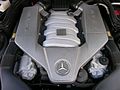
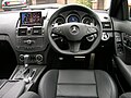
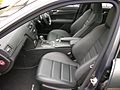
 2008 Mercedes Benz C63 AMG - Flickr - The Car Spy (1).jpg 1,600 × 1,200; 374 KB
-
 2008 Mercedes Benz C63 AMG - Flickr - The Car Spy (10).jpg 1,600 × 1,200; 181 KB
-
 2008 Mercedes Benz C63 AMG - Flickr - The Car Spy (11).jpg 1,600 × 1,200; 205 KB
-
 2008 Mercedes Benz C63 AMG - Flickr - The Car Spy (12).jpg 1,600 × 1,200; 138 KB
-
 2008 Mercedes Benz C63 AMG - Flickr - The Car Spy (13).jpg 1,600 × 1,200; 262 KB
-
 2008 Mercedes Benz C63 AMG - Flickr - The Car Spy (14).jpg 1,600 × 1,200; 278 KB
-
 2008 Mercedes Benz C63 AMG - Flickr - The Car Spy (15).jpg 1,600 × 1,200; 197 KB
-
 2008 Mercedes Benz C63 AMG - Flickr - The Car Spy (17).jpg 1,600 × 1,200; 260 KB
-
 2008 Mercedes Benz C63 AMG - Flickr - The Car Spy (18).jpg 1,600 × 1,200; 151 KB
-
 2008 Mercedes Benz C63 AMG - Flickr - The Car Spy (19).jpg 1,600 × 1,200; 189 KB
-
 2008 Mercedes Benz C63 AMG - Flickr - The Car Spy (2).jpg 1,600 × 1,200; 240 KB
-
 2008 Mercedes Benz C63 AMG - Flickr - The Car Spy (20).jpg 1,600 × 1,200; 194 KB
-
 2008 Mercedes Benz C63 AMG - Flickr - The Car Spy (21).jpg 1,600 × 1,200; 217 KB
-
 2008 Mercedes Benz C63 AMG - Flickr - The Car Spy (22).jpg 1,600 × 1,200; 148 KB
-
 2008 Mercedes Benz C63 AMG - Flickr - The Car Spy (23).jpg 1,600 × 1,200; 208 KB
-
 2008 Mercedes Benz C63 AMG - Flickr - The Car Spy (24).jpg 1,600 × 1,200; 225 KB
-
 2008 Mercedes Benz C63 AMG - Flickr - The Car Spy (25).jpg 1,600 × 1,200; 252 KB
-
 2008 Mercedes Benz C63 AMG - Flickr - The Car Spy (26).jpg 1,600 × 1,200; 497 KB
-
 2008 Mercedes Benz C63 AMG - Flickr - The Car Spy (3).jpg 1,600 × 1,200; 207 KB
-
 2008 Mercedes Benz C63 AMG - Flickr - The Car Spy (4).jpg 1,600 × 1,200; 206 KB
-
 2008 Mercedes Benz C63 AMG - Flickr - The Car Spy (5).jpg 1,600 × 1,200; 305 KB
-
 2008 Mercedes Benz C63 AMG - Flickr - The Car Spy (6).jpg 1,518 × 528; 131 KB
-
 2008 Mercedes Benz C63 AMG - Flickr - The Car Spy (7).jpg 1,395 × 699; 206 KB
-
 2008 Mercedes Benz C63 AMG - Flickr - The Car Spy (8).jpg 1,600 × 1,200; 174 KB
-
 2008 Mercedes Benz C63 AMG - Flickr - The Car Spy (9).jpg 1,600 × 1,200; 183 KB
-
 2008 Mercedes Benz C63 AMG - Flickr - The Car Spy.jpg 1,600 × 1,200; 475 KB
-
 An ornamented bay-window - geograph.org.uk - 1517139.jpg 480 × 640; 89 KB
-

-

-
 B4077 near Alstone Fields Farm - geograph.org.uk - 1537592.jpg 640 × 480; 227 KB
-
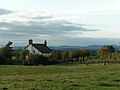
 Barff Hill Farm - geograph.org.uk - 1516581.jpg 640 × 427; 403 KB
-

-
 Catchwater Drain - geograph.org.uk - 1516540.jpg 640 × 427; 380 KB
-
 Cattle on The River Cuckmere - geograph.org.uk - 1733515.jpg 3,008 × 2,000; 2.74 MB
-
 Chiltern DVT Wrexham and Shropshire.JPG 1,632 × 1,224; 409 KB
-
 Cinderhill Mills, Todmorden - geograph.org.uk - 1529243.jpg 640 × 480; 106 KB
-

-
 Coast path approaching Rumps Point - geograph.org.uk - 1525378.jpg 480 × 640; 100 KB
-
 Commonwealth War Cemetery - geograph.org.uk - 1519412.jpg 640 × 480; 139 KB
-
 Coniston Road - geograph.org.uk - 1519368.jpg 640 × 486; 70 KB
-
 Cottage by the railway line - geograph.org.uk - 1516888.jpg 526 × 640; 97 KB
-
-
-
 Cow and calf - geograph.org.uk - 1517208.jpg 580 × 579; 97 KB
-
 Cowl of Shearnfold Oast - geograph.org.uk - 1515931.jpg 480 × 640; 79 KB
-
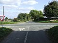
 Crossroads at Cross Lane Farm - geograph.org.uk - 1515239.jpg 640 × 480; 70 KB
-
 Crossroads at Thurnham - geograph.org.uk - 1516020.jpg 640 × 379; 81 KB
-
 Crossroads, Allt Laes - geograph.org.uk - 1516485.jpg 640 × 480; 82 KB
-
 Darlington Coat of Arms - geograph.org.uk - 1516183.jpg 480 × 640; 88 KB
-
 Derelict fenland farm shed - geograph.org.uk - 1516730.jpg 640 × 414; 111 KB
-
 Derngate Cove from Scarnor Point - geograph.org.uk - 1524168.jpg 640 × 480; 76 KB
-
 Descent into Little Rissington - geograph.org.uk - 1526022.jpg 640 × 427; 95 KB
-
 Devils Punchbowl - panoramio.jpg 3,872 × 2,592; 4.49 MB
-
 Disconnected - geograph.org.uk - 1516053.jpg 466 × 640; 64 KB
-
 Disused Railway Bridge - geograph.org.uk - 1515571.jpg 640 × 480; 159 KB
-
 Double gate on Poplar Farm - geograph.org.uk - 1515791.jpg 640 × 426; 116 KB
-
 Dounan Bay looking north west - geograph.org.uk - 1624145.jpg 640 × 422; 77 KB
-
 Dounan Bay looking south west - geograph.org.uk - 1624149.jpg 640 × 478; 71 KB
-

-
 Dromara Street, Belfast - geograph.org.uk - 1516196.jpg 640 × 543; 300 KB
-
 Stone Stairway to Bell Tower - geograph.org.uk - 1515720.jpg 640 × 480; 72 KB
-
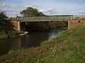
 Dyke at Wrampool Bridge - geograph.org.uk - 1525784.jpg 640 × 426; 279 KB
-
 East Ness Bridge - geograph.org.uk - 1516824.jpg 640 × 480; 103 KB
-
 Eden Bridge - geograph.org.uk - 1515906.jpg 640 × 480; 89 KB
-
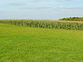 Edge of maize - geograph.org.uk - 1537639.jpg 640 × 480; 196 KB
-
 Electric fence (detail) - geograph.org.uk - 1516747.jpg 483 × 640; 183 KB
-

-
 Farm shed beside the A1101 - geograph.org.uk - 1516876.jpg 640 × 480; 61 KB
-
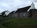
 Farmhouse on village edge - geograph.org.uk - 1515943.jpg 480 × 640; 72 KB
-
 Field and view near Horsecombe - geograph.org.uk - 1523626.jpg 640 × 410; 71 KB
-

-

-
 Footbridge over Kirkby Beck - geograph.org.uk - 1521464.jpg 640 × 480; 123 KB
-
 Footpath to Combe - geograph.org.uk - 1523813.jpg 495 × 640; 123 KB
-
 Footpath to Keith at Braehead - geograph.org.uk - 1516909.jpg 640 × 544; 130 KB
-
 Forest by the A686 - geograph.org.uk - 1515899.jpg 640 × 480; 76 KB
-
 Forest track, Glen Doll Forest - geograph.org.uk - 1535081.jpg 640 × 480; 171 KB
-
 Forestry Machinery being Unloaded - geograph.org.uk - 1532399.jpg 640 × 480; 306 KB
-
 Full of Berries - geograph.org.uk - 1515918.jpg 431 × 640; 85 KB
-
 Gate across the coastal path - geograph.org.uk - 1625223.jpg 640 × 468; 126 KB
-
 Gate and bus stop Wilshaw Road - geograph.org.uk - 1516286.jpg 640 × 480; 104 KB
-
 Gated private farm track - geograph.org.uk - 1516885.jpg 640 × 447; 83 KB
-
 Gateway and track to Stockland Farm - geograph.org.uk - 1516427.jpg 640 × 480; 79 KB
-
 Gateway to Frieslands Farm - geograph.org.uk - 1525768.jpg 640 × 427; 104 KB
-

-
 Grin Low - geograph.org.uk - 1518773.jpg 640 × 479; 84 KB
-
 Hall Place House - geograph.org.uk - 1516768.jpg 640 × 360; 69 KB
-
 Hanlith Bridge - geograph.org.uk - 1521490.jpg 640 × 480; 133 KB
-
 Heading north on the A424 - geograph.org.uk - 1526072.jpg 640 × 427; 58 KB
-
 Hedging along main road - geograph.org.uk - 1515228.jpg 640 × 480; 66 KB
-
-
 Higher Collaton - geograph.org.uk - 1523728.jpg 640 × 480; 92 KB
-
 Hillside and a Deer Fence - geograph.org.uk - 1524519.jpg 640 × 480; 57 KB
-
 Hillside near Maryknowle Farm - geograph.org.uk - 1523694.jpg 640 × 480; 108 KB
-
 Holiday homes, Cotswold Water Park - geograph.org.uk - 1517906.jpg 640 × 480; 236 KB
-
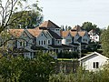
 Houses by the railway line - geograph.org.uk - 1516060.jpg 640 × 445; 91 KB
-
 Hut on the hill - geograph.org.uk - 1515843.jpg 640 × 480; 94 KB
-

-

-

-

-
 Irrigation reservoir on Harris Farms - geograph.org.uk - 1517187.jpg 640 × 488; 96 KB
-
 Junction at Shoothill - geograph.org.uk - 1515800.jpg 640 × 480; 116 KB
-

-

-
 Just leave me alone.. - geograph.org.uk - 1515639.jpg 640 × 480; 86 KB
-

-
 Knoll Lane, Netherthong - geograph.org.uk - 1516292.jpg 640 × 463; 61 KB
-
 Knoll Lane, Netherthong ^2 - geograph.org.uk - 1516300.jpg 640 × 480; 66 KB
-
 Lady's Well, among the trees. - geograph.org.uk - 1517674.jpg 640 × 480; 78 KB
-
 Lane at Southwood Farms, looking north - geograph.org.uk - 1517236.jpg 640 × 480; 167 KB
-

-
 Lifebelt at irrigation reservoir - geograph.org.uk - 1517196.jpg 640 × 449; 119 KB
-
 Limestone Barn at West Ness - geograph.org.uk - 1516835.jpg 640 × 480; 106 KB
-
 Local amenity sign posts, Aboyne - geograph.org.uk - 1517162.jpg 640 × 480; 144 KB
-
 Locked gate on the obscured path - geograph.org.uk - 1524490.jpg 640 × 480; 87 KB
-
 Lone Tree - geograph.org.uk - 1515884.jpg 640 × 481; 131 KB
-
 Long Meadow, south of Hampton Magna - geograph.org.uk - 1517769.jpg 640 × 427; 100 KB
-
 Looking north from Harris Farm - geograph.org.uk - 1516706.jpg 640 × 426; 120 KB
-
 Looking to Ayle Common - geograph.org.uk - 1515889.jpg 640 × 480; 91 KB
-
 Looking Towards Keith - geograph.org.uk - 1516959.jpg 640 × 427; 58 KB
-
 Looking Towards Newmill - geograph.org.uk - 1516966.jpg 640 × 431; 64 KB
-
 Looking towards the Kingsbridge estuary - geograph.org.uk - 1523076.jpg 640 × 480; 107 KB
-
 Lorry trailer - advertising board - geograph.org.uk - 1516326.jpg 640 × 451; 79 KB
-

-
 Low Bradshaw Hill - geograph.org.uk - 1515873.jpg 640 × 480; 79 KB
-
 M8 from Bogfoot Bridge - geograph.org.uk - 1515976.jpg 640 × 427; 77 KB
-

-
 Main Road ahead - geograph.org.uk - 1515805.jpg 640 × 480; 62 KB
-
 How Hill Tower - geograph.org.uk - 1525573.jpg 480 × 640; 50 KB
-
 Marquis Drive Junction - geograph.org.uk - 1519491.jpg 640 × 480; 83 KB
-
 Medieval Site of Coberley - geograph.org.uk - 1515560.jpg 640 × 480; 95 KB
-
 MetchleyFortEarthworks.jpg 640 × 480; 86 KB
-

-
 Mill stream, Bow Wow, South Cerney - geograph.org.uk - 1518008.jpg 640 × 480; 284 KB
-
 Minor road from Shilton to the B4477 - geograph.org.uk - 1524854.jpg 640 × 427; 68 KB
-
 Minor road to Low Farm - geograph.org.uk - 1516588.jpg 640 × 427; 362 KB
-
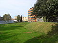
 Moat Crescent-Moatway, Great Malvern - geograph.org.uk - 1537569.jpg 640 × 480; 221 KB
-
 Moel Arthur - geograph.org.uk - 1525830.jpg 640 × 480; 91 KB
-
 Montgomery Avenue, Hampton Magna - geograph.org.uk - 1517742.jpg 640 × 427; 94 KB
-

-
 National Trust house in Port Quin - geograph.org.uk - 1524176.jpg 640 × 480; 93 KB
-
 Nelson Terrace at Keith - geograph.org.uk - 1516857.jpg 640 × 408; 84 KB
-
 Ness Bridge, River Rye - geograph.org.uk - 1515969.jpg 640 × 480; 118 KB
-
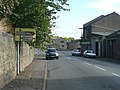
 Newsome Road, Huddersfield - geograph.org.uk - 1516330.jpg 640 × 480; 56 KB
-

-
 Oak by the Hobnails Inn - geograph.org.uk - 1537601.jpg 640 × 480; 261 KB
-
 Old Abutment - geograph.org.uk - 1515980.jpg 640 × 480; 104 KB
-
 Old Budbrooke Road - geograph.org.uk - 1517670.jpg 640 × 427; 121 KB
-
 Old gated entrance to Toddington Manor - geograph.org.uk - 1537612.jpg 640 × 480; 247 KB
-
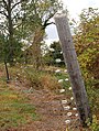
 Old Iron Straining post - geograph.org.uk - 1515616.jpg 480 × 640; 153 KB
-
 Old Lane. "The Smalls" - geograph.org.uk - 1515645.jpg 640 × 480; 145 KB
-
 Old Railway Bridge Abutment - geograph.org.uk - 1515576.jpg 640 × 480; 127 KB
-
 Old Road - geograph.org.uk - 1515787.jpg 640 × 480; 122 KB
-
 Old road sign, Halifax Road, Elland - geograph.org.uk - 1518849.jpg 640 × 480; 114 KB
-
 Old Rush - geograph.org.uk - 1516601.jpg 640 × 427; 397 KB
-
 Old Shieling - geograph.org.uk - 1526765.jpg 640 × 480; 52 KB
-
 Old stone bridge over the Dally Burn - geograph.org.uk - 1625226.jpg 640 × 456; 125 KB
-
 Old Telephone Box at Elkstone - geograph.org.uk - 1515832.jpg 417 × 640; 86 KB
-
 Old Track Bed for the MandSWJR - geograph.org.uk - 1515600.jpg 640 × 480; 160 KB
-
 Oldhamstocks Burn - geograph.org.uk - 1516294.jpg 640 × 480; 87 KB
-
 On The Path To Rossinish - geograph.org.uk - 1526995.jpg 640 × 480; 354 KB
-
 On The Way To Rossinish - geograph.org.uk - 1527034.jpg 640 × 480; 379 KB
-
 Onion skins and detritus composting - geograph.org.uk - 1516688.jpg 640 × 426; 186 KB
-
 Onions and onion detritus composting - geograph.org.uk - 1516691.jpg 640 × 426; 184 KB
-
 Onions and wooden crates - geograph.org.uk - 1517155.jpg 640 × 480; 81 KB
-
 Onions composting at Engine Farm - geograph.org.uk - 1515769.jpg 640 × 426; 104 KB
-
 Open Countryside - geograph.org.uk - 1517176.jpg 640 × 480; 105 KB
-
 Ormeau Road, Belfast - geograph.org.uk - 1516248.jpg 640 × 404; 256 KB
-
 Outcrop just north of The Schil - geograph.org.uk - 1530031.jpg 480 × 640; 74 KB
-
 Parked in the fens - geograph.org.uk - 1517148.jpg 640 × 560; 76 KB
-
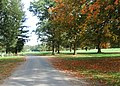
 Parkland drive - geograph.org.uk - 1523622.jpg 640 × 457; 187 KB
-
 Parkland drive - geograph.org.uk - 1523627.jpg 640 × 457; 175 KB
-

-
 Pick your own pumpkins - geograph.org.uk - 1516897.jpg 640 × 456; 85 KB
-
 Ploughleys Barn - geograph.org.uk - 1521520.jpg 640 × 480; 98 KB
-
 Proposal to Build a New Bridge - geograph.org.uk - 1515905.jpg 480 × 640; 70 KB
-
 Pubs of Gosport - The Park Tavern - geograph.org.uk - 1529341.jpg 640 × 480; 77 KB
-

-
 Pye Green View - geograph.org.uk - 1519407.jpg 480 × 640; 60 KB
-
 Railway Bridge - geograph.org.uk - 1515739.jpg 640 × 480; 107 KB
-
 Railway embankment above Burbage - geograph.org.uk - 1518837.jpg 640 × 405; 76 KB
-
 Railway line to Beverley - geograph.org.uk - 1516562.jpg 640 × 427; 359 KB
-
 Parish church of St Michael, Roosebeck.jpg 640 × 480; 65 KB
-
 Recycling containers - geograph.org.uk - 1516476.jpg 640 × 451; 94 KB
-
 Relay box beside railway line - geograph.org.uk - 1516474.jpg 640 × 462; 88 KB
-
 Rest in Peace - geograph.org.uk - 1519424.jpg 480 × 640; 117 KB
-
 Riggs Road Bridge, Ryton - geograph.org.uk - 1515893.jpg 640 × 480; 86 KB
-

-
 River Rye - geograph.org.uk - 1515896.jpg 640 × 480; 104 KB
-

-
 Road Bridge over Disused Railway - geograph.org.uk - 1515607.jpg 640 × 480; 131 KB
-
 Road junction at Elland Bridge - geograph.org.uk - 1518876.jpg 640 × 445; 99 KB
-
 Road junction at Pilling Lane Ends - geograph.org.uk - 1525778.jpg 640 × 426; 187 KB
-
 Road junction in Sherrard's Green - geograph.org.uk - 1537567.jpg 640 × 480; 214 KB
-

-
 Road junction near Tarn Farm - geograph.org.uk - 1525803.jpg 640 × 426; 223 KB
-
 Road over Ness Bridge - geograph.org.uk - 1516017.jpg 640 × 480; 78 KB
-
 Road through Milton Under Wychwood - geograph.org.uk - 1526091.jpg 640 × 427; 45 KB
_Acleris_emargana_(3970522152).jpg)
.jpg)
.jpg)
.jpg)
.jpg)
.jpg)
.jpg)
.jpg)
.jpg)
.jpg)
.jpg)
.jpg)
.jpg)
.jpg)
.jpg)
.jpg)
.jpg)
.jpg)
.jpg)
.jpg)
.jpg)
.jpg)
.jpg)
.jpg)
.jpg)


_-_geograph.org.uk_-_1516747.jpg)
_-_geograph.org.uk_-_1516883.jpg)


_-_geograph.org.uk_-_1517229.jpg)


_-_geograph.org.uk_-_1516715.jpg)
_-_geograph.org.uk_-_1516716.jpg)
_-_geograph.org.uk_-_1516722.jpg)


_north_of_Shippea_Hill_station_-_geograph.org.uk_-_1516878.jpg)


.jpg)