Category:United Kingdom photographs taken on 2006-02-13
Jump to navigation
Jump to search
| ← | Monday 13 February 2006 | → | ||
| ← | February 2006 | → | ||

United Kingdom photographs taken on 13 February 2006.
Image files should be categorized here automatically using {{taken on}} template. Direct categorisation is also possible, if automatic is impossible.
Subcategories
This category has the following 2 subcategories, out of 2 total.
Media in category "United Kingdom photographs taken on 2006-02-13"
The following 200 files are in this category, out of 217 total.
(previous page) (next page)-
 "The Fort" - geograph.org.uk - 121618.jpg 640 × 480; 97 KB
-
 2006-02-13 - London - Victoria - Bus Stop - Kazan - Shopping - Oriental W (4888664646).jpg 1,569 × 2,351; 2.03 MB
-

-
 A3 Roundabout - geograph.org.uk - 121783.jpg 640 × 480; 70 KB
-
 A50, Longton - geograph.org.uk - 122110.jpg 640 × 480; 67 KB
-
 Abandoned Cottage - geograph.org.uk - 121594.jpg 640 × 480; 91 KB
-

-
 All Saints, East Barsham, Norfolk - geograph.org.uk - 320359.jpg 640 × 454; 146 KB
-
 All Saints, East Barsham, Norfolk - geograph.org.uk - 320361.jpg 640 × 417; 107 KB
-

-
 Anthorn - geograph.org.uk - 125084.jpg 640 × 480; 71 KB
-
 Anthorn comms masts - geograph.org.uk - 125140.jpg 480 × 640; 65 KB
-
 Aqueduct, Fort Augustus, Inverness-shire - geograph.org.uk - 125977.jpg 480 × 640; 528 KB
-
 Arlosh House - geograph.org.uk - 125022.jpg 640 × 480; 83 KB
-
 Bajaj in Essex TM0724 121 - geograph.org.uk - 123127.jpg 1,600 × 1,200; 359 KB
-
 Baldastard Mains - geograph.org.uk - 121832.jpg 640 × 480; 98 KB
-
 Barnacle Geese near Anthorn - geograph.org.uk - 126312.jpg 640 × 480; 49 KB
-
 Bastion Cottage - geograph.org.uk - 121781.jpg 640 × 480; 149 KB
-
 BDO - geograph.org.uk - 121565.jpg 480 × 640; 75 KB
-
 Beckbrow - geograph.org.uk - 125309.jpg 640 × 480; 59 KB
-
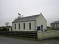
 Birtley - Primitive Methodist Church.jpg 640 × 454; 113 KB
-
 Bow of Fife - geograph.org.uk - 121803.jpg 640 × 480; 70 KB
-
 Bridleway to Elloughton - geograph.org.uk - 121540.jpg 640 × 480; 180 KB
-
 Bungalow - geograph.org.uk - 121692.jpg 640 × 480; 65 KB
-
 Cattle Grid at the top of Park Bank - geograph.org.uk - 122023.jpg 640 × 427; 65 KB
-
 Clatto Reservoir - geograph.org.uk - 121825.jpg 640 × 480; 54 KB
-
 Coldfall Wood - geograph.org.uk - 121560.jpg 640 × 480; 123 KB
-
 Collessie village and church - geograph.org.uk - 121719.jpg 480 × 640; 70 KB
-
 Copse on the hill - geograph.org.uk - 121725.jpg 446 × 640; 69 KB
-
 Cordraine Orange Hall - geograph.org.uk - 121666.jpg 640 × 480; 64 KB
-
 Corner plot - geograph.org.uk - 121562.jpg 640 × 480; 78 KB
-
 Crags - geograph.org.uk - 122364.jpg 640 × 480; 34 KB
-
 Crawford Priory -roads - geograph.org.uk - 121820.jpg 640 × 480; 80 KB
-
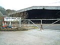 Cults Brickworks - geograph.org.uk - 121818.jpg 640 × 480; 94 KB
-
 Cults Farm - geograph.org.uk - 121819.jpg 640 × 480; 65 KB
-
 Cults Mill Farm - geograph.org.uk - 121814.jpg 640 × 480; 108 KB
-
 Dan and the Minx - geograph.org.uk - 331803.jpg 480 × 640; 125 KB
-
 Detail of Cordraine Orange Hall - geograph.org.uk - 121672.jpg 480 × 640; 60 KB
-
 Devil's Pulpit - geograph.org.uk - 124773.jpg 480 × 640; 108 KB
-
 Druminnis Presbyterian Church - geograph.org.uk - 121703.jpg 640 × 480; 59 KB
-
 Druminnis Presbyterian Church Hall - geograph.org.uk - 121704.jpg 640 × 480; 53 KB
-
 Drystone Wall - geograph.org.uk - 122365.jpg 640 × 480; 58 KB
-
 Dunbog Church - geograph.org.uk - 121742.jpg 640 × 480; 68 KB
-
 Dunbog Hill - geograph.org.uk - 121738.jpg 640 × 480; 82 KB
-
 East Barsham Church.jpg 640 × 454; 175 KB
-
 East Raynham to Colkirk road, Norfolk - geograph.org.uk - 123694.jpg 640 × 480; 279 KB
-
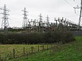 Electricity Sub Station - geograph.org.uk - 121609.jpg 640 × 480; 82 KB
-
 Ellerby Bank Top - geograph.org.uk - 123638.jpg 640 × 479; 73 KB
-
 Elmwood Golf Club - geograph.org.uk - 121823.jpg 640 × 480; 60 KB
-
 Washdyke Lane - geograph.org.uk - 131836.jpg 640 × 480; 145 KB
-
 Entrance Gate - geograph.org.uk - 121571.jpg 640 × 427; 101 KB
-
 Estate road - geograph.org.uk - 121796.jpg 640 × 480; 85 KB
-
 Farmstead - geograph.org.uk - 121691.jpg 640 × 480; 38 KB
-
 Fodder container - geograph.org.uk - 121715.jpg 640 × 480; 102 KB
-
 Footpath To Morthen - geograph.org.uk - 121856.jpg 640 × 427; 128 KB
-
 Gas Production Site - geograph.org.uk - 121676.jpg 640 × 427; 79 KB
-
 Gate & Stile Above Cwm Rheidol.jpg 640 × 480; 114 KB
-
 Glenduckie Hill - geograph.org.uk - 121774.jpg 640 × 480; 85 KB
-
 Grass Track - geograph.org.uk - 121855.jpg 640 × 427; 79 KB
-
 Grey House - geograph.org.uk - 121746.jpg 640 × 480; 90 KB
-
 Halhill Farm - geograph.org.uk - 121721.jpg 640 × 480; 72 KB
-
 Hamiltonsbawn Orange Hall.jpg 640 × 480; 94 KB
-
 Hill Teasses Farm - geograph.org.uk - 121833.jpg 640 × 480; 77 KB
-
 Hound sanctuary - geograph.org.uk - 121813.jpg 640 × 480; 146 KB
-
 House - geograph.org.uk - 121700.jpg 640 × 480; 93 KB
-
 House beside Norrie's Law - geograph.org.uk - 121830.jpg 640 × 480; 88 KB
-
 House with sheep grazing. - geograph.org.uk - 121698.jpg 640 × 480; 75 KB
-
 In Port - geograph.org.uk - 122822.jpg 640 × 480; 69 KB
-
 Kame Bridge - geograph.org.uk - 121828.jpg 640 × 480; 129 KB
-
 Kildarton Parish Church - geograph.org.uk - 121740.jpg 640 × 480; 93 KB
-
 Kildarton Parish Hall - geograph.org.uk - 121744.jpg 640 × 480; 96 KB
-
 Lake at Pensychnant - geograph.org.uk - 122366.jpg 640 × 480; 45 KB
-
 All Saints Laughton - geograph.org.uk - 147658.jpg 427 × 640; 47 KB
-
 Laurelvale Cricket Club - geograph.org.uk - 121679.jpg 640 × 480; 69 KB
-
 Ledcrieff Loch - geograph.org.uk - 121552.jpg 640 × 427; 118 KB
-
 Letham - geograph.org.uk - 121797.jpg 640 × 480; 96 KB
-
 Little Common Lane - geograph.org.uk - 121852.jpg 640 × 427; 94 KB
-
 Long Loch on a dreich day. - geograph.org.uk - 121518.jpg 640 × 427; 93 KB
-
 Long Ship Short Harbour - geograph.org.uk - 139066.jpg 640 × 480; 58 KB
-
 Longford, Coventry, UK - panoramio.jpg 2,560 × 1,920; 805 KB
-
 Longton Park - geograph.org.uk - 121613.jpg 640 × 480; 108 KB
-
 Longton War Memorial - geograph.org.uk - 121620.jpg 640 × 480; 79 KB
-
 Lough Navar Air Monitoring Station - geograph.org.uk - 121685.jpg 450 × 300; 39 KB
-
 M1 between J47 and J46, Garforth - geograph.org.uk - 121477.jpg 640 × 479; 102 KB
-
 Main line - geograph.org.uk - 121824.jpg 480 × 640; 110 KB
-
 Marine Drive - geograph.org.uk - 122374.jpg 640 × 481; 117 KB
-
 Marine Drive - geograph.org.uk - 122375.jpg 640 × 480; 44 KB
-
 Marlacoo Lake - geograph.org.uk - 121694.jpg 640 × 480; 75 KB
-
 Marlacoo Orange Hall - geograph.org.uk - 121695.jpg 640 × 480; 86 KB
-
 Mast on a hill - geograph.org.uk - 121794.jpg 640 × 480; 85 KB
-
 Melville Home Farm - geograph.org.uk - 121788.jpg 640 × 480; 63 KB
-
 Melville House - geograph.org.uk - 121786.jpg 640 × 420; 73 KB
-
 Modern House - geograph.org.uk - 121675.jpg 640 × 480; 99 KB
-
 Monimail Church - geograph.org.uk - 121801.jpg 640 × 480; 89 KB
-
 Mountain lake - geograph.org.uk - 122360.jpg 640 × 480; 39 KB
-
 Muddy track - geograph.org.uk - 121734.jpg 640 × 480; 117 KB
-
 Muirhead Farm - geograph.org.uk - 121827.jpg 640 × 480; 97 KB
-
 Mullavilly Parish Church - geograph.org.uk - 121606.jpg 640 × 480; 107 KB
-
 Near Garnedd wen - geograph.org.uk - 122358.jpg 640 × 480; 42 KB
-
 New Bungalow - geograph.org.uk - 121757.jpg 640 × 480; 81 KB
-
 New Gilston Farm - geograph.org.uk - 121834.jpg 640 × 480; 69 KB
-
 Newton Arlosh - geograph.org.uk - 125003.jpg 640 × 480; 51 KB
-
 Newton Mulgrave Woods - 2006 - geograph.org.uk - 123629.jpg 640 × 473; 119 KB
-

-
 Newton Mulgrave, North Yorkshire.jpg 640 × 545; 71 KB
-
 Office Park - geograph.org.uk - 121561.jpg 640 × 480; 82 KB
-
 Old cemetery - geograph.org.uk - 121790.jpg 640 × 480; 80 KB
-

-
 Paradise - geograph.org.uk - 121826.jpg 640 × 480; 118 KB
-
 Pistyll Gwyn Quarry - geograph.org.uk - 121469.jpg 640 × 480; 108 KB
-
 Railway Bridge - geograph.org.uk - 121664.jpg 640 × 427; 97 KB
-
 Remains of a railway bridge - geograph.org.uk - 121756.jpg 640 × 480; 131 KB
-
 Richhill Presbyterian Church - geograph.org.uk - 121785.jpg 640 × 480; 72 KB
-
 Richhill Presbyterian Church - geograph.org.uk - 121789.jpg 640 × 480; 96 KB
-
 River Yarrow - geograph.org.uk - 126351.jpg 452 × 639; 180 KB
-
 Road Sign - geograph.org.uk - 121697.jpg 640 × 480; 99 KB
-
 Rowley Manor - geograph.org.uk - 121511.jpg 640 × 480; 128 KB
-
 Silos - geograph.org.uk - 121829.jpg 480 × 640; 60 KB
-
 Solway Holiday Village - geograph.org.uk - 124482.jpg 640 × 480; 49 KB
-
 South East of Springfield - geograph.org.uk - 121821.jpg 640 × 480; 70 KB
-
 Springfield - geograph.org.uk - 121804.jpg 640 × 480; 74 KB
-
 Springfield Station - geograph.org.uk - 121816.jpg 640 × 480; 77 KB
-
 St Mark's Parish Church - geograph.org.uk - 121776.jpg 480 × 640; 106 KB
-
 St Mark's, Armagh 121776.jpg 480 × 640; 88 KB
-
 St Mary's Church - geograph.org.uk - 131368.jpg 640 × 480; 189 KB
-
 St Mary's Church at Caerhun - geograph.org.uk - 209651.jpg 640 × 427; 79 KB
-
 St Mary's Church, Cefn Meriadog - geograph.org.uk - 1579595.jpg 640 × 479; 53 KB
-
 St Mary's Church, Cefn Meriadog - geograph.org.uk - 1579600.jpg 640 × 480; 49 KB
-
 St Matthew's Parish Church - geograph.org.uk - 121792.jpg 640 × 480; 88 KB
-
 St Patrick's Cathedral, Armagh - geograph.org.uk - 121762.jpg 640 × 480; 86 KB
-
 St Patrick's CoI Cathedral, Armagh.jpg 640 × 480; 100 KB
-
 St Tudno Graveyard - geograph.org.uk - 122373.jpg 640 × 480; 45 KB
-
 Stair from Lympstone Station Car Park - geograph.org.uk - 1208866.jpg 480 × 640; 137 KB
-
 Standing Stone - geograph.org.uk - 122357.jpg 640 × 480; 41 KB
-
 Steps - geograph.org.uk - 121671.jpg 640 × 427; 94 KB
-
 Stone Circle - geograph.org.uk - 122361.jpg 640 × 480; 35 KB
-
 Swanland Village - geograph.org.uk - 121558.jpg 640 × 387; 72 KB
-
 Swanland Village.jpg 640 × 412; 74 KB
-
 T-junction - geograph.org.uk - 121808.jpg 640 × 480; 128 KB
-
 Teuchats Farm - geograph.org.uk - 121831.jpg 640 × 386; 47 KB
-
 The Afon Haffes near Glyntawe - geograph.org.uk - 769669.jpg 640 × 480; 124 KB
-
 The Hiron Rail Bridge - geograph.org.uk - 121737.jpg 640 × 480; 90 KB
-
 The King's Arms - geograph.org.uk - 126551.jpg 640 × 480; 85 KB
-
 The old kirk in Kirkton of Cults - geograph.org.uk - 121811.jpg 480 × 640; 83 KB
-
 The road to Raywell - geograph.org.uk - 121516.jpg 640 × 480; 109 KB
-
 The road to Riplingham - geograph.org.uk - 121513.jpg 640 × 480; 91 KB
-
 The road to Welton - geograph.org.uk - 121512.jpg 640 × 480; 69 KB
-
 The road to Welton - geograph.org.uk - 121554.jpg 640 × 335; 50 KB
-
 The Willerby to Welton road - geograph.org.uk - 121543.jpg 640 × 364; 67 KB
-
 The Willerby to Welton road - geograph.org.uk - 121545.jpg 640 × 343; 46 KB
-

-
 Towerbridge.JPG 2,848 × 2,136; 3.23 MB
-

-
 Vale Of Rheidol Railway foot crossing - geograph.org.uk - 202903.jpg 640 × 480; 143 KB
-
 Water tank - geograph.org.uk - 121747.jpg 640 × 480; 68 KB
-
 Waterfront - geograph.org.uk - 131401.jpg 640 × 480; 153 KB
-
 White House - geograph.org.uk - 121702.jpg 640 × 480; 81 KB
-
 Whitefield - geograph.org.uk - 121729.jpg 640 × 480; 112 KB
-
 Wigfair - geograph.org.uk - 1579552.jpg 640 × 480; 67 KB
-
 Windermere - Baddeley Memorial Clock - geograph.org.uk - 122650.jpg 480 × 640; 104 KB
-
 Windermere United Reformed Church - geograph.org.uk - 122653.jpg 640 × 480; 106 KB
-
 Winter feed for the sheep. - geograph.org.uk - 121845.jpg 640 × 480; 105 KB
-
 Woodland west of Swanland - geograph.org.uk - 121549.jpg 640 × 480; 136 KB
-
 Abbeytown - geograph.org.uk - 124524.jpg 640 × 480; 50 KB
-
 Allerton Bywater - geograph.org.uk - 121483.jpg 640 × 479; 132 KB
-
 B5307 near Sleightholme - geograph.org.uk - 124497.jpg 640 × 480; 60 KB
-

-
 Calais House - geograph.org.uk - 123623.jpg 640 × 463; 44 KB
-
 Cell phone mast - geograph.org.uk - 122877.jpg 640 × 480; 60 KB
-
 Craig y nos - geograph.org.uk - 769687.jpg 640 × 480; 64 KB
-
 Detached House - geograph.org.uk - 121599.jpg 640 × 480; 129 KB
-
 Drovers route to Feagour - geograph.org.uk - 122541.jpg 640 × 480; 101 KB
-
 Dunstaffnage Peninsula - geograph.org.uk - 121501.jpg 640 × 480; 125 KB
-
 Fields around Fox Lane Farm. - geograph.org.uk - 121844.jpg 640 × 480; 105 KB
-
 Flocking Barnacle Geese - geograph.org.uk - 126322.jpg 640 × 480; 62 KB
-

-
 Four miles to Richhill - geograph.org.uk - 121752.jpg 640 × 480; 109 KB
-
 Fox Lane. - geograph.org.uk - 121847.jpg 640 × 480; 96 KB
-
 Friars Lane - geograph.org.uk - 121658.jpg 640 × 427; 94 KB
-
 Glenmahon Avenue, Portadown - geograph.org.uk - 121592.jpg 640 × 480; 79 KB
-

-
 High Croft, Stopper Lane, Rimington - geograph.org.uk - 122762.jpg 640 × 426; 143 KB
-
 High Tranmire farm - geograph.org.uk - 123602.jpg 640 × 480; 50 KB
-

-
 Junction on the A171 - geograph.org.uk - 126804.jpg 640 × 427; 65 KB
-
 Kilmore village over the weak bridge - geograph.org.uk - 338141.jpg 640 × 480; 90 KB
-
 Lady Ferrers' Wood, Raynham Park, Norfolk - geograph.org.uk - 123688.jpg 640 × 480; 331 KB
-
 Large New House - geograph.org.uk - 121601.jpg 640 × 480; 76 KB
-
 Ledcreiff Loch - geograph.org.uk - 121764.jpg 640 × 427; 118 KB
-
 Low Borrowby - geograph.org.uk - 123579.jpg 640 × 492; 114 KB
-
 M18 M1 Intersection - geograph.org.uk - 121853.jpg 640 × 427; 75 KB
-
 Maryholme - geograph.org.uk - 124502.jpg 640 × 480; 56 KB
-
 Mines Cottage - geograph.org.uk - 122770.jpg 640 × 426; 171 KB
-
 Money's Carr, East Raynham, Norfolk - geograph.org.uk - 123689.jpg 640 × 480; 261 KB
-
 Moss Side - geograph.org.uk - 124489.jpg 640 × 480; 73 KB
-
 My Little Tonka - geograph.org.uk - 122819.jpg 640 × 480; 101 KB
-
 Near Garnedd wen - geograph.org.uk - 122359.jpg 640 × 480; 50 KB
-

-
 Old Military Road - geograph.org.uk - 122700.jpg 640 × 480; 89 KB
-
 Parish of Ballymore - St Mark's Church - geograph.org.uk - 121688.jpg 640 × 480; 105 KB

.jpg)


_where_Newton_Lane_crosses_Newton_Beck_-_geograph.org.uk_-_123569.jpg)


