Category:Union House, Liverpool
Jump to navigation
Jump to search
| Object location | | View all coordinates using: OpenStreetMap |
|---|
building in Liverpool, Merseyside, England, UK  | |||||
| Upload media | |||||
| Instance of | |||||
|---|---|---|---|---|---|
| Location | Liverpool, Merseyside, North West England, England | ||||
| Heritage designation |
| ||||
 | |||||
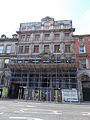
21 Victoria Street, built 1882 and originally named Palace Chambers. (There is no 23 Victoria Street)
Media in category "Union House, Liverpool"
The following 4 files are in this category, out of 4 total.
-
 Union House, Liverpool 2019.jpg 2,360 × 2,984; 5.71 MB
-
 Union House, Liverpool August 2016 (1).JPG 3,456 × 4,608; 7.09 MB
-
 Union House, Liverpool August 2016 (2).JPG 3,456 × 4,608; 6.2 MB
-
 Union House, Liverpool.jpg 1,488 × 1,984; 613 KB
.JPG)
.JPG)
