Category:Umivik Bay
Jump to navigation
Jump to search
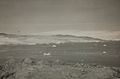
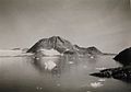
English: Umivik Bay is a bay in King Frederick VI Coast, southeastern Greenland. It is part of the Sermersooq municipality. Unlike the jagged and forbidding appearance of most fjord systems in East Greenland, the Umivik area has a relatively gentle shape. Here the massive Greenland ice sheet comes down to the shore in smooth, even undulations and the landscape looks unbroken, with only few glimpses of bare rock.
bay in Greenland  | |||||
| Upload media | |||||
| Instance of | |||||
|---|---|---|---|---|---|
| Location | Sermersooq, Greenland, Denmark | ||||
 | |||||
Media in category "Umivik Bay"
The following 9 files are in this category, out of 9 total.
-
 Gyldenlove Glacier (5610836462).jpg 1,200 × 900; 560 KB
-
 Nansen Greenland Crossing Map af.png 626 × 682; 67 KB
-
 Nansen Greenland Crossing Map no labels.png 626 × 682; 54 KB
-
 Nansen Greenland Crossing Map.png 626 × 682; 55 KB
-
 No-nb bldsa 3b032.jpg 5,475 × 3,590; 2.82 MB
-
 No-nb bldsa 3b044.jpg 2,664 × 2,279; 1.07 MB
-
 No-nb bldsa 3b161.jpg 6,113 × 4,275; 3.32 MB
-
 Southeast Greenland Fjord.jpg 2,816 × 1,584; 750 KB
-
 Umivik Bugt - SE coast-Greenland-pclmaps-oclc-8322829 c 13.jpg 882 × 531; 236 KB
.jpg)


