Category:Ulricehamn kyrka
Jump to navigation
Jump to search
| Object location | | View all coordinates using: OpenStreetMap |
|---|
|
This is a category about an ecclesiastical monument in Sweden, number 21300000008437 (sub-number: 21400000549741) in the RAÄ buildings database.
|
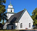
church building in Ulricehamn Municipality, Västra Götaland County, Sweden  | |||||
| Upload media | |||||
| Instance of | |||||
|---|---|---|---|---|---|
| Location | Ulricehamn, Ulricehamn Municipality, Västra Götaland County, Sweden | ||||
| Located in or next to body of water | |||||
| Diocese | |||||
| Has use |
| ||||
| Occupant |
| ||||
| Heritage designation |
| ||||
| Inception |
| ||||
 | |||||
Subcategories
This category has the following 2 subcategories, out of 2 total.
Media in category "Ulricehamn kyrka"
The following 18 files are in this category, out of 18 total.
-
 Kyrkan i Ulricehamn, Västergötland. ArkDes ARKM.1976-113-3648.jpg 3,000 × 2,933; 5.37 MB
-
 Ulricehamn - KMB - 16001000242664.jpg 780 × 533; 160 KB
-
 Ulricehamn - KMB - 16001000320004.jpg 787 × 524; 123 KB
-
 Ulricehamn Kyrka.jpg 3,923 × 3,264; 7.32 MB
-
 Ulricehamn, Gamla kyrkogården - KMB - 16000200169828.jpg 661 × 600; 60 KB
-
 Ulricehamns kyrka 2010.jpg 2,112 × 2,816; 889 KB
-
 Ulricehamns kyrka 2019.jpg 2,745 × 3,660; 2.61 MB
-
 Ulricehamns kyrka.JPG 3,072 × 4,608; 3.51 MB
-
 Ulrichamns kyrka - KMB - 16000200169756.jpg 765 × 600; 95 KB
-
 Ulrichamns kyrka - KMB - 16000200169758.jpg 440 × 600; 55 KB
-
 Ulrichamns kyrka - KMB - 16000200169759.jpg 933 × 600; 123 KB
-
 Ulrichamns kyrka - KMB - 16000200169761.jpg 517 × 600; 43 KB
-
 Ulrichamns kyrka - KMB - 16000200169762.jpg 820 × 600; 68 KB
-
 Ulrichamns kyrka - KMB - 16000200169763.jpg 442 × 600; 51 KB
-
 Ulrichamns kyrka - KMB - 16000200169766.jpg 440 × 600; 68 KB
-
 Ulrichamns kyrka - KMB - 16000200169767.jpg 440 × 600; 34 KB
-
 Ulrichamns kyrka - KMB - 16000200169826.jpg 449 × 600; 47 KB
-
 Ulrichamns kyrka - KMB - 16000200169827.jpg 426 × 600; 60 KB


