Category:Uiterburen 53, Zuidbroek
Jump to navigation
Jump to search
| Object location | | View all coordinates using: OpenStreetMap |
|---|
 | |||||
| Upload media | |||||
| Instance of | |||||
|---|---|---|---|---|---|
| Location | Zuidbroek, Midden-Groningen, Groningen, Netherlands | ||||
| Street address |
| ||||
| Located on street | |||||
| Heritage designation |
| ||||
 | |||||
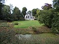
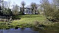
Nederlands: Drostenborgh
|
This is a category about rijksmonument number 520972
|
| Address |
|
Media in category "Uiterburen 53, Zuidbroek"
The following 7 files are in this category, out of 7 total.
-
 Drostenborgh en tuin Zuidbroek 1.jpg 3,648 × 2,736; 2.2 MB
-
 Drostenborgh en tuin Zuidbroek 2.jpg 2,736 × 3,648; 1.25 MB
-
 Drostenborgh en tuin Zuidbroek 3.jpg 3,648 × 2,736; 2.31 MB
-
 Gockingaborg fantasiebeeld (1656).jpg 331 × 227; 37 KB
-
 Nummer 53, aanzicht - Uiterburen - 20211039 - RCE.jpg 1,200 × 1,197; 435 KB
-
 Nummer 53, aanzicht - Uiterburen - 20211040 - RCE.jpg 1,200 × 1,200; 441 KB
-
 Zuidbroek - Drostenborgh.jpg 4,716 × 2,653; 13.25 MB


.jpg)


