Category:US National Archives series: Landscape Views of the Area Along the Northwest Boundary, compiled 1857 - 1862
Jump to navigation
Jump to search
Media in category "US National Archives series: Landscape Views of the Area Along the Northwest Boundary, compiled 1857 - 1862"
The following 108 files are in this category, out of 108 total.
-
 Active Passage. Saturna Group, looking West - NARA - 305490.tif 4,200 × 3,000; 36.05 MB
-
 Akleu Cache. Near the Kootenay R. looking S - NARA - 305516.jpg 3,600 × 2,700; 3.63 MB
-
 Akleu Cache. Near the Kootenay R. looking S - NARA - 305516.tif 3,600 × 2,700; 27.81 MB
-

-

-

-

-
 Camp Kootenay West (Narris' Camp) looking N.W - NARA - 305517.jpg 4,200 × 3,000; 3.75 MB
-
 Camp Kootenay West (Narris' Camp) looking N.W - NARA - 305517.tif 4,200 × 3,000; 36.05 MB
-
 Camp Mooyie (1 1-4 miles N. of 49th parallel). Peak bears N. 20 W - NARA - 305518.jpg 3,900 × 2,700; 3.54 MB
-
 Camp Mooyie (1 1-4 miles N. of 49th parallel). Peak bears N. 20 W - NARA - 305518.tif 3,900 × 2,700; 30.13 MB
-
-

-
 Camp on Flathead River (49th parallel) looking up (W. 25. N.) - NARA - 305529.jpg 4,200 × 3,000; 3.63 MB
-
 Camp on Flathead River (49th parallel) looking up (W. 25. N.) - NARA - 305529.tif 4,200 × 3,000; 36.05 MB
-

-

-
 Camp on stream near Waterton Lake. peak bears E. 30. S - NARA - 305549.jpg 3,900 × 2,700; 2.26 MB
-
 Camp on stream near Waterton Lake. peak bears E. 30. S - NARA - 305549.tif 3,900 × 2,700; 30.13 MB
-
 Camp Sumass. Sumass Prairie, looking N - NARA - 305497.jpg 4,200 × 3,000; 3.51 MB
-
 Camp Sumass. Sumass Prairie, looking N - NARA - 305497.tif 4,200 × 3,000; 36.05 MB
-

-
 Camp. (foot of summit-E. side) Kishenehn or Boundary Pass. High peak bears W - NARA - 305540.tif 3,900 × 2,700; 30.13 MB
-

-

-
 Cascade Kishenehn Pass (E side summit) Peak bears S. 50. E - NARA - 305543.jpg 3,900 × 2,700; 2.66 MB
-
 Cascade Kishenehn Pass (E side summit) Peak bears S. 50. E - NARA - 305543.tif 3,900 × 2,700; 30.13 MB
-

-

-
 Cascade on left bank Columbia River (Cascades of the Columbia) - NARA - 305501.jpg 3,600 × 3,000; 2.59 MB
-
 Cascade on left bank Columbia River (Cascades of the Columbia) - NARA - 305501.tif 3,600 × 3,000; 30.9 MB
-

-

-
 Chelemta Depot. From right bank of the Koontenay looking up - NARA - 305513.jpg 5,100 × 3,000; 4.14 MB
-
 Chelemta Depot. From right bank of the Koontenay looking up - NARA - 305513.tif 5,100 × 3,000; 43.77 MB
-

-

-
 Falls of the Kootenay (ak. Kaph-Kleh) from near the trail - NARA - 305525.jpg 4,200 × 3,000; 4 MB
-
 Falls of the Kootenay (ak. Kaph-Kleh) from near the trail - NARA - 305525.tif 4,200 × 3,000; 36.05 MB
-
 Great Falls on the Palouse River from summit of Cliffs on right bank - NARA - 305504.jpg 4,200 × 3,000; 3.58 MB
-
 Great Falls on the Palouse River from summit of Cliffs on right bank - NARA - 305504.tif 4,200 × 3,000; 36.05 MB
-

-

-
 Head Kellispelm Lake-near head of lake looking South. (Sienitic Cliffs) - NARA - 305512.jpg 3,600 × 3,000; 2.71 MB
-
 Head Kellispelm Lake-near head of lake looking South. (Sienitic Cliffs) - NARA - 305512.tif 3,600 × 3,000; 30.9 MB
-

-

-

-

-
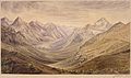
 Kintla Mountains and lower lake, from spur of Boundary Mountain - NARA - 305534.jpg 4,200 × 3,000; 3.08 MB
-
 Kintla Mountains and lower lake, from spur of Boundary Mountain - NARA - 305534.tif 4,200 × 3,000; 36.05 MB
-
 Kintla Mountains from the summit of Kishnehnehna - NARA - 305532.jpg 5,100 × 3,000; 3.56 MB
-
 Kintla Mountains from the summit of Kishnehnehna - NARA - 305532.tif 5,100 × 3,000; 43.77 MB
-
-

-
-

-

-
 Kootenay River (Southernmost crossing) looking S. (down) from left bank - NARA - 305524.tif 3,900 × 2,700; 30.13 MB
-
 Kootenay River. Junction with Elk River. View from trail on right bank - NARA - 305522.jpg 3,600 × 2,400; 2.45 MB
-
 Kootenay River. Junction with Elk River. View from trail on right bank - NARA - 305522.tif 3,600 × 2,400; 24.72 MB
-
 Kootenay River. looking down from near Camp Kootenay East - NARA - 305523.jpg 3,900 × 2,700; 3.06 MB
-
 Kootenay River. looking down from near Camp Kootenay East - NARA - 305523.tif 3,900 × 2,700; 30.13 MB
-
 Lake on E. side summit Kishenehn Pass looking E - NARA - 305539.jpg 3,900 × 2,700; 2.17 MB
-
 Lake on E. side summit Kishenehn Pass looking E - NARA - 305539.tif 3,900 × 2,700; 30.13 MB
-
 Lake to the Westward of Akamina Lake. Peak bears S. 35. W - NARA - 305546.jpg 3,900 × 2,700; 2.73 MB
-
 Lake to the Westward of Akamina Lake. Peak bears S. 35. W - NARA - 305546.tif 3,900 × 2,700; 30.13 MB
-
 Looking W. toward summit Kishenehn Pass left hand peak bears S. 10. W - NARA - 305542.jpg 4,200 × 3,000; 3.23 MB
-
 Looking W. toward summit Kishenehn Pass left hand peak bears S. 10. W - NARA - 305542.tif 4,200 × 3,000; 36.05 MB
-
 Mooyie River looking South (down) from the 49th parallel - NARA - 305519.jpg 3,900 × 2,700; 3.1 MB
-
 Mooyie River looking South (down) from the 49th parallel - NARA - 305519.tif 3,900 × 2,700; 30.13 MB
-
-

-
 Mt. Kishenehn peak bears N. 50. W - NARA - 305535.jpg 3,900 × 2,700; 2.84 MB
-
 Mt. Kishenehn peak bears N. 50. W - NARA - 305535.tif 3,900 × 2,700; 30.13 MB
-
 Plante's Crossing-Spokane River and Plains-trail runs N. N. E - NARA - 305507.jpg 3,600 × 2,400; 2.3 MB
-
 Plante's Crossing-Spokane River and Plains-trail runs N. N. E - NARA - 305507.tif 3,600 × 2,400; 24.72 MB
-

-

-
 Rocky Mountain peaks from Camp on Josephs' Prairie. "Steeples" bear N.E - NARA - 305521.jpg 5,100 × 3,000; 4.67 MB
-
 Rocky Mountain peaks from Camp on Josephs' Prairie. "Steeples" bear N.E - NARA - 305521.tif 5,100 × 3,000; 43.77 MB
-
 Sandstone Mountain bearing E. 20. S. Kishenehn Pass (E. side of summit) - NARA - 305541.jpg 3,900 × 2,700; 2.61 MB
-
 Sandstone Mountain bearing E. 20. S. Kishenehn Pass (E. side of summit) - NARA - 305541.tif 3,900 × 2,700; 30.13 MB
-
-

-

-

-

-

-

-

-
 Straits of Haro. Stewart's Island in the centre - NARA - 305491.jpg 4,200 × 3,000; 2.66 MB
-
 Straits of Haro. Stewart's Island in the centre - NARA - 305491.tif 4,200 × 3,000; 36.05 MB
-

-

-
 Summit of Cascade Mountains, from trail looking West - NARA - 305498.jpg 8,700 × 1,500; 3.3 MB
-
 Summit of Cascade Mountains, from trail looking West - NARA - 305498.tif 8,700 × 1,500; 37.34 MB
-

-

-
 Valley of Kootenay from hills near Akleu Cache (left bank) looking N.W - NARA - 305515.jpg 5,100 × 3,000; 3.97 MB
-
 Valley of Kootenay from hills near Akleu Cache (left bank) looking N.W - NARA - 305515.tif 5,100 × 3,000; 43.77 MB
-

-
-

-

-
-

-


_looking_N._50._E._across_Akamina_Lake_down_Akamina_Pass_toward_the_Sascatchawan_Plains_-_NARA_-_305545.jpg)
_in..._-_NARA_-_305531.jpg)
_looking_N.W_-_NARA_-_305517.jpg)
._Peak_bears_N._20_W_-_NARA_-_305518.jpg)
_-_NARA_-_305526.jpg)
_looking_up_(W._25._N.)_-_NARA_-_305529.jpg)


_Kishenehn_or_Boundary_Pass._High_peak_bears_W_-_NARA_-_305540.jpg)
_-_NARA_-_305503.jpg)
_Peak_bears_S._50._E_-_NARA_-_305543.jpg)

_-_NARA_-_305501.jpg)
_-_NARA_-_305500.jpg)


_from_near_the_trail_-_NARA_-_305525.jpg)


_-_NARA_-_305512.jpg)


_from_trail_up_the_pass_looking_N._60._E_-_NARA_-_305537.jpg)
_and_Kishenehn_Pass_from_summit_of_Pass_looking_South_-_NARA_-_305538.jpg)
_looking_S._(down)_from_left_bank_-_NARA_-_305524.jpg)


_from_the_49th_parallel_-_NARA_-_305519.jpg)


_from_the_summit_of_Flathead_Pass._Boundary_mountain_bears_N._50._E_-_NARA_-_305528.jpg)

_-_NARA_-_305541.jpg)


_Military_Road_from_Colville_to_Walla_Walla_-_NARA_-_305506.jpg)


_looking_N.W_-_NARA_-_305515.jpg)


