Category:U.S. Route 281 in Texas
Jump to navigation
Jump to search
section of U.S. Numbered Highway in Texas, United States   _map.svg) | |||||
| Upload media | |||||
| Instance of | |||||
|---|---|---|---|---|---|
| Location | Texas | ||||
| Transport network | |||||
| Owned by | |||||
| Maintained by | |||||
| Inception |
| ||||
| Length |
| ||||
| |||||
English: Media related to U.S. Route 281 in Texas, a section of U.S. Numbered Highway in Texas, United States.
Subcategories
This category has the following 3 subcategories, out of 3 total.
A
B
Media in category "U.S. Route 281 in Texas"
The following 12 files are in this category, out of 12 total.
-
 Atascosa County road map.svg 1,180 × 688; 1.17 MB
-
 Downtown George West, TX IMG 0977.JPG 2,592 × 1,944; 1 MB
-
 Downtown Pleasanton, Texas IMG 2602.JPG 4,000 × 3,000; 2.57 MB
-
 I-37, I-410 interchange, San Antonio, Texas.JPG 3,872 × 2,592; 2.12 MB
-
 I-410 and US281 Interchange Stack Aerial.jpg 3,600 × 2,400; 3.46 MB
-
 Lake Marble Falls Texas 2023.jpg 3,708 × 2,472; 4.68 MB
-
 NB US 281 in San Antonio.jpg 3,264 × 2,448; 1.58 MB
-
 U.S. 281 west of San Antonio, TX IMG 1918.JPG 4,320 × 3,240; 1.94 MB
-
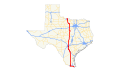 US 281 (TX) map.svg 870 × 516; 541 KB
-
 US 281 Texas 1926.svg 1,485 × 1,440; 30 KB
-
 US 281, San Antonio, Texas.JPG 3,872 × 2,592; 6.21 MB
-
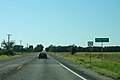 US281sRoad-PaloPintoCountyLine (36974737563).jpg 2,400 × 1,600; 1.62 MB


.jpg)