Category:Tygart Valley Homesteads
Jump to navigation
Jump to search
historic district in West Virginia, United States  | |||||
| Upload media | |||||
| Instance of | |||||
|---|---|---|---|---|---|
| Location | West Virginia | ||||
| Heritage designation |
| ||||
 | |||||
- More information:
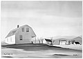
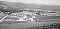
Lot 1718, Tygart Valley homesteads, near Elkins, West Virginia. 1936–1939. A subsistence homestead project of the U.S. Resettlement Administration. Photographed by Marion Post Wolcott, Carl Mydans, and John Vachon for the Farm Security Administration. - More information:
Lot 178, Tygart Valley Homesteads, an FSA project in Dailey, 11 miles southwest of Elkins, West Virginia. December 1941. Photographed by Arthur Rothstein for the Farm Security Administration. Photographs show interiors showing families and friends. Nursery group, woodwork shop, radio quiz, baseball games and other school activities. Baptist Sunday school, doctor and nurse from group health examining patients at home, in clinic. Stockpiles and operation of Dimension Lumber Mill. Products of weaving program. - More information
Media in category "Tygart Valley Homesteads"
The following 9 files are in this category, out of 9 total.
-

-
 Facts about Tygart Valley homesteads (IA factsabouttygart00unit).pdf 1,083 × 1,531, 14 pages; 607 KB
-
 Special Skills Division illustration 7 Jansen.jpg 4,080 × 2,910; 6.56 MB
-
 Special Skills Division illustration 8 Jansen.jpg 3,790 × 2,640; 5.62 MB
-
 The wash line. Tygart Valley, West Virginia LCCN2017799284.tif 4,872 × 5,072; 47.13 MB
-
 Trading Post stores at Tygart Valley Homesteads.jpg 7,200 × 5,304; 22.73 MB
-
 Tygart Valley Homesteads, West Virginia.jpg 4,110 × 2,000; 4.5 MB
-
 Untitled photo possibly related to CCC boys working at Tygart Valley Homesteads, WV.jpg 4,388 × 3,201; 5.81 MB
-
 Weaving Shop, Tygart Valley Homesteads.jpg 4,100 × 2,700; 5.12 MB


