Category:Turmhügel Katzbach
Jump to navigation
Jump to search
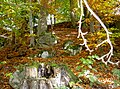
This is the category of the Bavarian Baudenkmal (cultural heritage monument) with the ID D-3-6642-0007 (Wikidata)
|
| Object location | | View all coordinates using: OpenStreetMap |
|---|
castle  | |||||
| Upload media | |||||
| Instance of |
| ||||
|---|---|---|---|---|---|
| Location | Waldmünchen, Cham, Upper Palatinate, Bavaria, Germany | ||||
| Heritage designation |
| ||||
| Inception |
| ||||
 | |||||
Media in category "Turmhügel Katzbach"
The following 7 files are in this category, out of 7 total.
-
 KatzbachTurmhügel 01.jpg 2,304 × 1,704; 873 KB
-
 KatzbachTurmhügel 02.jpg 2,304 × 1,704; 933 KB
-
 KatzbachTurmhügel 03.jpg 2,304 × 1,704; 897 KB
-
 KatzbachTurmhügel 04.jpg 2,304 × 1,704; 901 KB
-
 KatzbachTurmhügel 05.jpg 2,304 × 1,704; 911 KB
-
 KatzbachTurmhügel 06.jpg 2,304 × 1,704; 880 KB
-
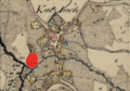 Turmhügel Katzbach.PNG 595 × 415; 623 KB


