Category:Tunnel Trail (no 5), Clifty Falls SP
Jump to navigation
Jump to search
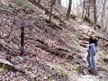
Tunnel Falls is located on the Deans Branch of Clifty Creek in the mid-section of Clifty Falls State Park. The falls has a 83 feet (25 m) drop.
| Camera location | | View all coordinates using: OpenStreetMap |
|---|
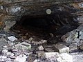
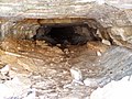
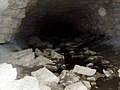
The Tunnel is the remains of an unfinished rail line from Madison on the Ohio River, to the higher flatland's and then into the State. See the Madison Railroad Trail, W Third St. in Madison for the successful route.
| Camera location | | View all coordinates using: OpenStreetMap |
|---|
Media in category "Tunnel Trail (no 5), Clifty Falls SP"
The following 17 files are in this category, out of 17 total.
-
 Old Railroad bridge abutments (Clifty Falls SP).JPG 1,984 × 1,488; 693 KB
-
 The Tunnel (south end).JPG 1,984 × 1,488; 721 KB
-
 The Tunnel Trail.JPG 640 × 480; 104 KB
-
 Tunnel (North end) P4110010.jpg 1,600 × 1,200; 586 KB
-
 Tunnel (North end) P4110012.jpg 1,984 × 1,488; 607 KB
-
 Tunnel (south end) P4110013.jpg 1,984 × 1,488; 674 KB
-
 Tunnel (south end) P4110016.jpg 1,984 × 1,488; 558 KB
-
 Tunnel (south end) P4110017.jpg 1,984 × 1,488; 658 KB
-
 Tunnel Trail P4110018.jpg 1,488 × 1,984; 659 KB
-
 Tunnel Trail P4110020.jpg 1,488 × 1,984; 1.98 MB
-
 Tunnel Trail P4110021.jpg 1,200 × 1,600; 606 KB
-
 Tunnel Trail P4110022.jpg 1,984 × 1,488; 1.94 MB
-
 Tunnel Trail P4110023.jpg 1,984 × 1,488; 1.95 MB
-
 Tunnel Trail P4110024.jpg 1,984 × 1,488; 1.97 MB
-
 Tunnel Trail P4110025.jpg 1,488 × 1,984; 1.71 MB
-
 Tunnel Trail P4110026.jpg 1,984 × 1,488; 657 KB
-
 Tunnel Trail P4110028.jpg 1,984 × 1,488; 697 KB
.JPG)
.JPG)

_P4110010.jpg)
_P4110012.jpg)
_P4110013.jpg)
_P4110016.jpg)
_P4110017.jpg)


