Category:Tropical Storm Trases (2022)
Jump to navigation
Jump to search
Pacific tropical storm in 2022   | |||||
| Upload media | |||||
| Instance of |
| ||||
|---|---|---|---|---|---|
| Part of | |||||
| Location | Pacific Ocean, international waters | ||||
| Start time |
| ||||
| End time |
| ||||
| Follows | |||||
| Followed by | |||||
| |||||
Media in category "Tropical Storm Trases (2022)"
The following 12 files are in this category, out of 12 total.
-
 2022 CIMSS 07W Trases visible infrared satellite loop.gif 800 × 600; 3.89 MB
-
 2022 JTWC 07W forecast map.wp0722.gif 1,490 × 1,072; 86 KB
-
 2022 JTWC 07W IR satellite imagery.jpg 1,024 × 1,024; 602 KB
-
 2022 NRL WP072022 TRASES infrared-gray satellite.png 1,400 × 1,400; 544 KB
-
 2022 NRL WP072022 TRASES visible satellite.png 1,400 × 1,400; 1.75 MB
-
 Ester 2022-07-29 0800Z.jpg 1,550 × 2,000; 4.72 MB
-
 Ester 2022-07-30 0435Z.jpg 3,900 × 5,000; 6.22 MB
-
 Ester 2022-07-31 0220Z.jpg 4,900 × 6,500; 9.85 MB
-
 Songda & Ester.jpg 5,500 × 5,500; 23.69 MB
-
 Songda and Ester 2022-07-30 0400Z.jpg 3,580 × 2,670; 12.95 MB
-
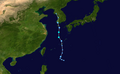 Trases 2022 track.png 2,700 × 1,669; 3.12 MB
-
 Trases 2022-07-31 0500Z.jpg 3,500 × 4,500; 7.1 MB


