Category:Trimingham gravel quarry
Jump to navigation
Jump to search
| Object location | | View all coordinates using: OpenStreetMap |
|---|
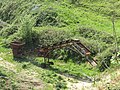
English: Trimingham Gravel Pit is located on Middle Street in the parish of Trimingham. It was first quarried after World War Two but is now disused. A great deal of the sand and gravel extracted from this Quarry was used in the construction of the near-by Bacton Gas Terminal.
Media in category "Trimingham gravel quarry"
The following 19 files are in this category, out of 19 total.
-
 -2016-03-25 Trimingham gravel pit, Middle Street, Norfolk.jpg 1,600 × 1,200; 876 KB
-
 -2018-12-12 Gateway into Trimingham Gravel quarry, Trimingham.JPG 5,152 × 3,864; 5.2 MB
-
 -2018-12-12 JCB js 200LC, Trimingham Gravel quarry, Trimingham.JPG 5,152 × 3,864; 7.68 MB
-
 -2018-12-12 Trimingham Gravel quarry, Trimingham.JPG 5,152 × 3,864; 5.12 MB
-
 -2022-06-25 Bee-eater viewpoint, Trimingham quarry, Norfolk.jpg 5,154 × 3,410; 6.3 MB
-
 -2022-06-25 View from the Bee-eater viewpoint, Trimingham quarry, Norfolk.jpg 5,472 × 3,648; 5.58 MB
-
 -2022-06-26 Bee-eater (Merops apiaster), Trimingham, Norfolk (1).JPG 2,067 × 1,355; 530 KB
-
 -2022-06-26 Bee-eater (Merops apiaster), Trimingham, Norfolk (2).JPG 2,567 × 2,807; 1.42 MB
-
 -2022-07-11 Bee-eater viewpoint, Trimingham quarry, Norfolk (1).JPG 5,152 × 3,864; 6.48 MB
-
 -2022-07-11 Bee-eater viewpoint, Trimingham quarry, Norfolk (2).JPG 5,152 × 3,864; 6.7 MB
-
 -2022-07-11 Bee-eater viewpoint, Trimingham quarry, Norfolk (3).JPG 5,152 × 3,864; 7.26 MB
-
 -2022-07-11 Bee-eater viewpoint, Trimingham quarry, Norfolk (4).JPG 5,152 × 3,864; 9.78 MB
-
 -2022-07-11 Bee-eater viewpoint, Trimingham quarry, Norfolk (5).JPG 5,152 × 3,864; 9.96 MB
-
 -2022-07-11 Bee-eater viewpoint, Trimingham quarry, Norfolk (6).JPG 5,152 × 3,864; 8.79 MB
-
 -2022-07-11 Bee-eater viewpoint, Trimingham quarry, Norfolk (7).JPG 5,152 × 3,864; 8.61 MB
-

-

-
 2018-05-12 Old Quarry machinery, Sand conveyor, Middle Street, Trimingham.JPG 5,152 × 3,864; 10.19 MB
-
 2018-05-12 Old Quarry, Middle Street, Trimingham.JPG 5,152 × 3,864; 7.25 MB


,_Trimingham,_Norfolk_(1).JPG)
,_Trimingham,_Norfolk_(2).JPG)
.JPG)
.JPG)
.JPG)
.JPG)
.JPG)
.JPG)
.JPG)
.JPG)
.JPG)

