
Category:Triftanlage (Celle)
park in Celle, Germany | |||||
| Upload media | |||||
| Instance of | |||||
|---|---|---|---|---|---|
| Location | Celle, Lower Saxony, Germany | ||||
 | |||||
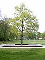
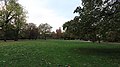
Deutsch: Die Triftanlage in Celle entstand aus der alten Viehtrift vor dem historischen Westerceller Tor. Nach einem Nutzungsverbot von 1833 wurde um 1864 die Grünfläche in einen Park im landschaftlichen Stil umgewandelt, ähnlich und parallel zu den damaligen Umgestaltungen des Französischen Gartens und des Schlossparks. Zuständig war das Oberhofmarschallamt in Hannover unter Carl Ernst von Malortie, die Planungen stammten von Christian Schaumburg, die Ausführung übernahm der Celler Hofgärtner L. Hinkeldeyn. Die Grün- und Erholungsfläche wird von den Straßen Trift und Bahnhofstraße begrenzt sowie der Arndtstraße im Westen. Lediglich die Verlängerung der Breite Straße teilt die Triftanlage in zwei Teile ...
English: The drove compound in Celle originated from the old drove in front of the historic Westerceller Gate. After the ban of its use in 1833, the green area was around 1864 transformed into a park in a scenic style, similar to and parallel to the transformations of the French garden and the castle park. The Oberhof Marschallamt was responsible in Hanover under Carl Ernst von Malortie, the plans were from Christian Schaumburg, the execution took over the Celler Hofgärtner L. Hinkeldeyn. The green and recreational area is bordered by the roads Trift and Bahnhofstraße as well as the Arndtstraße to the west. Only the extension of the Breite Strasse divides the driveway into two parts ...
Subcategories
This category has the following 2 subcategories, out of 2 total.
S
W
Media in category "Triftanlage (Celle)"
The following 24 files are in this category, out of 24 total.
-
 Denkmal "Celler Hasenjagd".jpg 2,288 × 3,040; 1.12 MB
-
 Inschrift Denkmal "Celler Hasenjagd".jpg 3,040 × 2,288; 1.16 MB
-

-
 Kriegerdenkmal, 2, Celle, Landkreis Celle.jpg 3,456 × 2,592; 2.99 MB
-
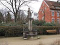 Schäferbrunnen, 1, Celle, Landkreis Celle.jpg 3,456 × 2,592; 3.46 MB
-
 Trift 9314.jpg 5,184 × 2,916; 14.68 MB
-
 Trift 9318.jpg 5,184 × 2,916; 11.5 MB
-
 Trift Celle.jpg 1,416 × 1,064; 575 KB
-
 Trift Denkmal Celler Hasenjagd 9159.jpg 3,200 × 3,200; 11.91 MB
-
 Trift Denkmal Celler Hasenjagd 9160.jpg 5,184 × 2,916; 15.9 MB
-
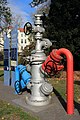
 Trift Entdeckerpfad Bohrlochverflanschung 9187.jpg 2,400 × 3,600; 8.66 MB
-
 Trift Entdeckerpfad Bohrlochverflanschung 9192.jpg 2,400 × 3,600; 8.53 MB
-
 Trift Entdeckerpfad Bohrmeißel 9178.jpg 3,200 × 3,200; 8.86 MB
-
 Trift Entdeckerpfad Bohrmeißel 9179.jpg 3,109 × 3,109; 7.96 MB
-
 Trift Entdeckerpfad Bohrmeißel 9180.jpg 3,200 × 3,200; 7.53 MB
-
 Trift Entdeckerpfad Bohrmeißel 9181.jpg 3,200 × 3,200; 7.65 MB
-
 Trift Entdeckerpfad Bohrmeißel 9182.jpg 2,240 × 3,360; 5.96 MB
-
 Trift Entdeckerpfad Erdöl, Erdgas, Erdwärme 9175.jpg 4,000 × 2,250; 9.49 MB
-
 Trift Entdeckerpfad Erdöl, Erdgas, Erdwärme Tafel1 9184.jpg 2,448 × 4,736; 9.98 MB
-
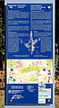 Trift Entdeckerpfad Erdöl, Erdgas, Erdwärme Tafel2 9185.jpg 2,320 × 4,208; 9.17 MB
-
 Trift Kriegsopfer Gedenkstätte Belgard-Schivelbein 9201.jpg 2,800 × 4,200; 11.3 MB
-
 Trift Kriegsopfer Gedenkstätte Marienwerder 9174.jpg 2,800 × 4,200; 12.15 MB
-

-


