Category:Trevor, Wrexham
Jump to navigation
Jump to search
village in Wrexham County Borough, Wales  | |||||
| Upload media | |||||
| Instance of | |||||
|---|---|---|---|---|---|
| Location | Wrexham County Borough, Wales | ||||
| Located in or next to body of water | |||||
 | |||||
Cymraeg: Pentref ym Mwrdeistref Sirol Wrecsam yw Trefor (Saesneg: Trevor). Fe'i lleolir tua hanner ffordd rhwng Llangollen a Rhiwabon ar yr A539.
English: Trevor is a village in the county borough of Wrexham (until 1974 in Denbighshire) in Wales. It is situated in the scenic Vale of Llangollen, on the A539 between Llangollen and Wrexham in the community of Llangollen Rural.

Subcategories
This category has the following 6 subcategories, out of 6 total.
Media in category "Trevor, Wrexham"
The following 36 files are in this category, out of 36 total.
-
 A539 in Trevor - geograph.org.uk - 924454.jpg 640 × 480; 82 KB
-
 Aqueduct from the South East - geograph.org.uk - 1627689.jpg 640 × 520; 86 KB
-
 Bryn Seion Methodist Chapel, Trevor - geograph.org.uk - 731482.jpg 640 × 443; 72 KB
-
 Canal Junction, Trevor - geograph.org.uk - 251631.jpg 640 × 436; 118 KB
-
 Croesiolyn by Tower Wood - geograph.org.uk - 72165.jpg 640 × 480; 105 KB
-
 Dorothy Hartley's grave, Froncysyllte - geograph.org.uk - 538346.jpg 640 × 480; 169 KB
-

-

-
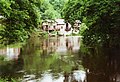
 Llangollen Canal at Trevor - geograph.org.uk - 640635.jpg 640 × 480; 118 KB
-
 Llangollen Canal bridge no. 33 - geograph.org.uk - 640608.jpg 640 × 480; 149 KB
-
 Llangollen Canal, Thomas Telford plaque - geograph.org.uk - 587557.jpg 640 × 480; 106 KB
-
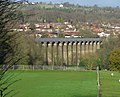
 Pontcysyllte Aqueduct - geograph.org.uk - 130791.jpg 640 × 429; 127 KB
-
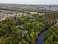
 Pontcysyllte from Froncysyllte. World heritage Site.jpg 4,272 × 2,848; 3.52 MB
-
 River Dee at Trevor - geograph.org.uk - 723282.jpg 637 × 436; 82 KB
-
 Telford Inn, Trevor.jpg 4,000 × 3,000; 1.52 MB
-
 The Aqueduct Inn - geograph.org.uk - 1242335.jpg 640 × 480; 98 KB
-
 The Aqueduct Inn, Fron Cysyllte - geograph.org.uk - 649921.jpg 640 × 428; 77 KB
-
 Track below Trevor Hall - geograph.org.uk - 83984.jpg 640 × 417; 86 KB
-
 Trefor from Froncysyllte Aqueduct - geograph.org.uk - 593087.jpg 640 × 480; 85 KB
-
 Trevor Basin - geograph.org.uk - 731476.jpg 640 × 480; 65 KB
-
 Trevor Garth - geograph.org.uk - 84504.jpg 640 × 414; 337 KB
-
 Trevor, Wrexham.jpg 4,000 × 3,000; 1.67 MB
-
 A stile into Jeffrey's Wood - geograph.org.uk - 1805496.jpg 1,500 × 1,000; 393 KB
-
 A Stream in the Sky - geograph.org.uk - 731480.jpg 480 × 640; 104 KB
-
 Afon Dyfrdwy at Trevor - geograph.org.uk - 640674.jpg 640 × 480; 92 KB
-
 Ancient craft - geograph.org.uk - 812231.jpg 427 × 640; 102 KB
-
 Converted Methodist Chapel in Garth - geograph.org.uk - 710618.jpg 640 × 480; 56 KB
-
 Converted mill at Trevor - geograph.org.uk - 266474.jpg 640 × 478; 108 KB
-
 Farmland above Garth - geograph.org.uk - 541835.jpg 590 × 445; 124 KB
-
 Football on the Flexys pitch - geograph.org.uk - 649906.jpg 640 × 428; 66 KB
-
 Footpath to Garth through Tower Wood - geograph.org.uk - 710611.jpg 640 × 480; 130 KB
-
 Garth cemetery - geograph.org.uk - 710617.jpg 640 × 480; 124 KB
-
 Holiday cottages at Nant Uchaf Farm - geograph.org.uk - 756702.jpg 640 × 480; 111 KB
-
 Lane junction near Black Wood - geograph.org.uk - 541833.jpg 640 × 480; 148 KB
-

-
 What is it Daddy^ - geograph.org.uk - 404165.jpg 480 × 640; 140 KB


