Help
Category
:
Trestle 791B
From Wikimedia Commons, the free media repository
Jump to navigation
Jump to search
Media in category "Trestle 791B"
The following 5 files are in this category, out of 5 total.
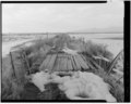
TRESTLE 791B. EAST VIEW, DECK - Promontory Route Railroad Trestles, Trestle 791B, 11 miles west of Corrine, Corinne, Box Elder County, UT HAER UTAH,2-CORI.V,1G-3.tif
4,983 × 4,034; 19.17 MB
TRESTLE 791B. EAST-NORTHEAST VIEW, EAST ABUTMENT, LONGITUDINAL BRACE DETAIL - Promontory Route Railroad Trestles, Trestle 791B, 11 miles west of Corrine, Corinne, Box Elder HAER UTAH,2-CORI.V,1G-5.tif
4,089 × 5,000; 19.5 MB
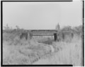
TRESTLE 791B. NORTH SIDE - Promontory Route Railroad Trestles, Trestle 791B, 11 miles west of Corrine, Corinne, Box Elder County, UT HAER UTAH,2-CORI.V,1G-2.tif
5,000 × 3,998; 19.07 MB
TRESTLE 791B. SOUTH SIDE - Promontory Route Railroad Trestles, Trestle 791B, 11 miles west of Corrine, Corinne, Box Elder County, UT HAER UTAH,2-CORI.V,1G-1.tif
5,000 × 3,979; 18.98 MB
TRESTLE 791B. WEST VIEW, DECK - Promontory Route Railroad Trestles, Trestle 791B, 11 miles west of Corrine, Corinne, Box Elder County, UT HAER UTAH,2-CORI.V,1G-4.tif
5,000 × 3,988; 19.02 MB
Categories
:
Promontory Route railroad trestles
Transcontinental Railroad Grade
Navigation menu
Personal tools
English
Not logged in
Talk
Contributions
Create account
Log in
Namespaces
Category
Discussion
English
Views
View
Edit
History
More
Search
Navigate
Main page
Welcome
Community portal
Village pump
Help center
Participate
Upload file
Recent changes
Latest files
Random file
Contact us
Tools
What links here
Related changes
Special pages
Permanent link
Page information
Get shortened URL
Download QR code
Print/export
Create a book
Download as PDF
Printable version
In Wikipedia
Add links