Category:Treis Vryses
Jump to navigation
Jump to search
| Upload media | |||||
| Instance of | |||||
|---|---|---|---|---|---|
| Location | Eastern Macedonia and Thrace, Decentralized Administration of Macedonia and Thrace, Greece | ||||
| Area |
| ||||
 | |||||
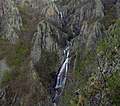
English: The Treis Vryses ("Three Fountains") region was so named long before becoming a Natura 2000 protected area. It is located in the Evros Mountains, part of the Rhodope Massif, in territory that was once part of Thrace. The Evros River flows through it on its way from Bulgaria to the Aegean. The Bulgarian and Turkish borders are close at hand. The area has changed nationalities a number of times in the last few centuries but currently has stabilized as being Greek. Rugged and historically contested terrain, it is gradually being depopulated by the abandonment of villages.
Media in category "Treis Vryses"
The following 5 files are in this category, out of 5 total.
-
 2οςΚΑΤΑΡΡΑΚΤΗΣ ΦΡΑΚΤΟΥ Η ΜΠΡΟΣΤΙΝΗ ΠΛΕΥΡΑ-FRAKTO SECOND FALL FRONT SIDE.jpg 4,480 × 2,520; 4.67 MB
-
 2οςΚΑΤΑΡΡΑΚΤΗΣ ΦΡΑΚΤΟΥ Η ΠΙΣΩ ΠΛΕΥΡΑ-FRAKTO SECOND FALL BACK SIDE.jpg 4,480 × 2,520; 5.11 MB
-
 FR 199.jpg 2,358 × 2,084; 2.25 MB
-
 StreetFor3BrusesVillage.jpg 3,000 × 4,496; 2.61 MB
-
 ΠΑΡΘΕΝΟ ΔΑΣΟΣ ΙΟΥΛΙΟΣ 13κ.ά 591.jpg 3,000 × 4,000; 5.03 MB


