Category:Trees in Wiltshire
Jump to navigation
Jump to search
Subcategories
This category has the following 9 subcategories, out of 9 total.
- Trees in Swindon (6 F)
A
- Avenues in Wiltshire (21 F)
F
- Fagus in Wiltshire (7 F)
T
- Trees in Salisbury (21 F)
Media in category "Trees in Wiltshire"
The following 200 files are in this category, out of 503 total.
(previous page) (next page)-
 "Old Man" in Churchill Gardens, Salisbury.jpg 4,500 × 6,000; 7.41 MB
-
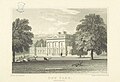 Neale(1818) p5.040 - New Park, Wiltshire.jpg 1,824 × 1,250; 597 KB
-

-
 A Japanese Pagoda Tree 2 in Churchill Gardens, Salisbury, UK.jpg 2,988 × 5,312; 6.43 MB
-
 A Japanese Pagoda Tree 3 in Churchill Gardens, Salisbury, UK.jpg 2,988 × 5,312; 1.89 MB
-
 A Japanese Pagoda Tree in Churchill Gardens, Salisbury, UK.jpg 2,988 × 5,312; 5.9 MB
-
 A tree above Marlborough - geograph.org.uk - 411069.jpg 640 × 480; 143 KB
-
 A tree in Savernake Forest - geograph.org.uk - 344468.jpg 480 × 640; 131 KB
-
 A tree in the London Road Cemetery, Salisbury.jpg 2,988 × 5,312; 5.37 MB
-
 Afternoon sun Longleat House gardens - geograph.org.uk - 414494.jpg 640 × 480; 76 KB
-
 Albourne1.jpg 1,024 × 768; 157 KB
-
 Alive and dead, Donhead st Andrew - geograph.org.uk - 1255430.jpg 640 × 480; 155 KB
-
 Alnus glutinosa catkins.jpg 4,000 × 2,248; 3.62 MB
-
 Alton Barn - geograph.org.uk - 457161.jpg 640 × 480; 112 KB
-
 Disused Chapel - geograph.org.uk - 298963.jpg 640 × 480; 149 KB
-
 Amesbury - The Nile Clumps Plantation & information board (geograph 4281365).jpg 1,024 × 768; 157 KB
-
 Ancient tree in the Harewarren - geograph.org.uk - 668191.jpg 480 × 640; 156 KB
-
 Ancient trees, near Cherry Orchard - geograph.org.uk - 392669.jpg 640 × 424; 79 KB
-

-
 Apple Tree and Tree House - geograph.org.uk - 300060.jpg 480 × 640; 169 KB
-
 Ash tree in field, Wick Down, Wiltshire - geograph.org.uk - 343311.jpg 640 × 480; 115 KB
-
 Ashton Keynes church (geograph 2388149).jpg 1,024 × 680; 263 KB
-
 At Salisbury 2023 034.jpg 6,960 × 4,640; 15.75 MB
-
 Autumn sunshine through the leaves. - geograph.org.uk - 1557620.jpg 640 × 590; 166 KB
-
 Avebury, UK - panoramio (3).jpg 2,048 × 1,150; 517 KB
-
 Baydon Church - geograph.org.uk - 1519115.jpg 640 × 512; 92 KB
-
 Baynton Down, near Imber - geograph.org.uk - 521325.jpg 640 × 480; 279 KB
-
 Bedwyn Church Bridge - geograph.org.uk - 1302877.jpg 640 × 427; 214 KB
-

-
 Beech tree, St Peter's Churchyard - geograph.org.uk - 1826861.jpg 480 × 640; 212 KB
-
 Beech trees, Throope Bottom - geograph.org.uk - 1651539.jpg 640 × 481; 170 KB
-
 Beech Wood - geograph.org.uk - 1238262.jpg 640 × 480; 61 KB
-
 Beeches beside the Ridgeway - geograph.org.uk - 248662.jpg 640 × 480; 211 KB
-
 Beeches, Maccoombe Down - geograph.org.uk - 274979.jpg 640 × 480; 153 KB
-
 Belted Galloway Cattle, Bishopstone - geograph.org.uk - 605514.jpg 640 × 480; 142 KB
-
 Berwick Bassett Clump - geograph.org.uk - 408848.jpg 640 × 480; 124 KB
-
 Berwick Bassett Clump, from the Ridgeway - geograph.org.uk - 1086015.jpg 1,024 × 701; 1.16 MB
-

-

-
 Bisected copse - geograph.org.uk - 147990.jpg 640 × 480; 107 KB
-
 Autumn Colour, Bishopstone - geograph.org.uk - 1008075.jpg 640 × 480; 168 KB
-
 Faulston Dovecote, Bishopstone - geograph.org.uk - 752029.jpg 640 × 480; 139 KB
-
 The dovecote at Faulston House - geograph.org.uk - 443674.jpg 640 × 610; 128 KB
-
 The Dovecote, Faulston House - geograph.org.uk - 293753.jpg 640 × 427; 109 KB
-
 Blossom near Woodford - geograph.org.uk - 735166.jpg 640 × 480; 131 KB
-
-
 St Andrews Church, Boscombe (geograph 1874037).jpg 640 × 480; 144 KB
-
 Bourne Hill Gardens 4.jpg 2,248 × 4,000; 3.03 MB
-
 Church of St. Anne, Bowden Hill, Wiltshire, UK - Diliff.jpg 6,001 × 4,710; 6.98 MB
-
 Christ Church (geograph 4416838).jpg 1,024 × 683; 248 KB
-
 Grade II* listed Christ Church, Bradford-on-Avon (geograph 3443542).jpg 687 × 800; 109 KB
-
 Bradford on Avon Holy Trinity Church.jpg 1,418 × 1,351; 1.47 MB
-
 Bridge over the Thames at Castle Eaton - geograph.org.uk - 2395656.jpg 1,024 × 680; 217 KB
-
 Bridleway to Faulston - geograph.org.uk - 312311.jpg 640 × 480; 135 KB
-
 Bristow Bridge - geograph.org.uk - 1170882.jpg 640 × 426; 113 KB
-

-
 Bristow Bridge, Kennet and Avon Canal - geograph.org.uk - 416108.jpg 640 × 503; 127 KB
-
 Bristow Bridge, Kennet and Avon Canal - geograph.org.uk - 791277.jpg 640 × 407; 97 KB
-
 St Peter ad Vincula church, Broad Hinton - geograph.org.uk - 522502.jpg 640 × 480; 294 KB
-
 Catkins, Pits Wood - geograph.org.uk - 1704257.jpg 480 × 640; 235 KB
-

-
 Cheddar Road, Moredon, Swindon - geograph.org.uk - 1381721.jpg 640 × 480; 133 KB
-

-
 Parish Church of Chittoe (exterior) - geograph.org.uk - 893144.jpg 450 × 640; 89 KB
-
 Churchill Gardens4.jpg 810 × 1,440; 260 KB
-
 St Nicholas's church, Upper Chute - geograph.org.uk - 999004.jpg 426 × 640; 177 KB
-
 Clump beside Odstock Down - geograph.org.uk - 507904.jpg 640 × 430; 187 KB
-
 Clump beside Old Shaftsbury Drove - geograph.org.uk - 498672.jpg 640 × 430; 60 KB
-
 Clumps Ahoy! (geograph 3452145).jpg 3,598 × 2,698; 1.6 MB
-
 ANZAC War Grave Cemetery, Codford St Mary - geograph.org.uk - 951383.jpg 640 × 480; 125 KB
-
 St Marys church, Collingbourne Kingston (geograph 3015572).jpg 2,592 × 1,944; 1.35 MB
-
 Colloway Clump - geograph.org.uk - 332404.jpg 640 × 480; 23 KB
-
 Cemetery at Compton Chamberlayne - geograph.org.uk - 329145.jpg 640 × 480; 119 KB
-
 Congregational Chapel, Horningsham - geograph.org.uk - 411569.jpg 640 × 480; 105 KB
-
 Coppiced trees at Blunsdon - geograph.org.uk - 308266.jpg 640 × 480; 122 KB
-
 Copse and wheat, Nether Wallop - geograph.org.uk - 483175.jpg 640 × 480; 142 KB
-
 Copse near Hanging Langford - geograph.org.uk - 1059163.jpg 640 × 480; 152 KB
-
 Copse near Stony Hill - geograph.org.uk - 1083858.jpg 640 × 481; 162 KB
-
 Copse near Willoughby Hedge Services - geograph.org.uk - 1259775.jpg 640 × 425; 50 KB
-
 Copse near Yarnbury Castle - geograph.org.uk - 705464.jpg 640 × 480; 140 KB
-
 Copse on a ploughed hillside - geograph.org.uk - 1528032.jpg 640 × 470; 127 KB
-
 Copse South of Maddington Down - geograph.org.uk - 361683.jpg 640 × 480; 176 KB
-
 Copse, Upper Upham - geograph.org.uk - 248614.jpg 640 × 480; 94 KB
-
 Copse, Wick Down - geograph.org.uk - 274278.jpg 640 × 478; 109 KB
-
 Copse, Woodlands Farm - geograph.org.uk - 265599.jpg 640 × 480; 107 KB
-
 Corner of Warner's Copse - geograph.org.uk - 509015.jpg 430 × 640; 198 KB
-
 St. Bartholomew's Church, Corsham - geograph.org.uk - 515518.jpg 640 × 480; 94 KB
-
 St Thomas Coulston England.jpg 640 × 480; 133 KB
-

-
 Dark trees, late afternoon - Nov 2012 - panoramio.jpg 4,000 × 3,000; 4.74 MB
-
 Dead or alive - Swallowcliffe - geograph.org.uk - 890715.jpg 640 × 480; 78 KB
-
 St James' Church - geograph.org.uk - 197981.jpg 640 × 480; 74 KB
-
 St James, Southbroom- churchyard (2) (geograph 4199726).jpg 640 × 470; 81 KB
-
 St. Peters Church, Devizes (geograph 5086124).jpg 640 × 428; 98 KB
-
 Douglas fir in Churchill Gardens, Salisbury.jpg 2,988 × 5,312; 8.84 MB
-
 Downstream from a footbridge - geograph.org.uk - 2498433.jpg 640 × 480; 138 KB
-
 Drive to Fern Farm, Hisomley - geograph.org.uk - 1282864.jpg 480 × 640; 213 KB
-
 Military graves - geograph.org.uk - 1142578.jpg 640 × 480; 87 KB
-
 Early catkins - geograph.org.uk - 118850.jpg 640 × 480; 133 KB
-

-
 East Grafton - Lych Gate - geograph.org.uk - 1448456.jpg 640 × 480; 108 KB
-
 East Grafton - St Nicholas Church - geograph.org.uk - 1448466.jpg 640 × 480; 71 KB
-
 St Mary's Church, East Knoyle - geograph.org.uk - 1037024.jpg 640 × 480; 86 KB
-
 East Knoyle Windmill - geograph.org.uk - 705345.jpg 640 × 407; 105 KB
-
 St Barnabas Church, Easterton - geograph.org.uk - 87933.jpg 640 × 462; 86 KB
-
 Edge of Little Gilbert's Copse - geograph.org.uk - 508709.jpg 640 × 430; 408 KB
-
 Elder by the byway, Compton Down - geograph.org.uk - 1452222.jpg 479 × 640; 209 KB
-
 Evening light - Nov 2012 - panoramio.jpg 3,000 × 4,000; 4.95 MB
-
 Evening skies near Tottons Down Barn - geograph.org.uk - 407469.jpg 640 × 480; 108 KB
-
 Evergreen trees, Shaw Forest Park, Swindon - geograph.org.uk - 1705791.jpg 2,640 × 1,980; 2.79 MB
-

-
 Fallen tree near The Green - geograph.org.uk - 1584331.jpg 640 × 481; 179 KB
-
 Fallen tree near The Green - geograph.org.uk - 1584338.jpg 640 × 480; 200 KB
-

-
 Farm bridge over the Thames - geograph.org.uk - 2390996.jpg 1,024 × 680; 272 KB
-

-
 Farmland and copse, Mildenhall Warren - geograph.org.uk - 265617.jpg 640 × 480; 110 KB
-
-

-
 Farmland west of Froxfield - geograph.org.uk - 1242992.jpg 640 × 480; 117 KB
-
 Field Barn - geograph.org.uk - 348139.jpg 640 × 480; 26 KB
-
 Field Boundary - geograph.org.uk - 682670.jpg 640 × 497; 133 KB
-
 St Martins Church, Fifield Bavant - geograph.org.uk - 349530.jpg 640 × 480; 148 KB
-
 Foxley church (geograph 2482384).jpg 2,592 × 1,944; 1.42 MB
-
 Churchyard, St Peter's Church - geograph.org.uk - 884843.jpg 640 × 480; 113 KB
-
 Fyfield Church - geograph.org.uk - 682211.jpg 640 × 480; 137 KB
-
 Game cover near Fifield Bavant - geograph.org.uk - 683092.jpg 640 × 489; 85 KB
-
-
 Grand Avenue at Park Pale, Savernake - geograph.org.uk - 1066541.jpg 417 × 640; 112 KB
-

-
 Grand Avenue Savernake Forest in autumn - geograph.org.uk - 1578283.jpg 640 × 471; 266 KB
-
 Great Bedwyn church and churchyard - geograph.org.uk - 667716.jpg 640 × 439; 102 KB
-
 Great Bedwyn Churchyard - geograph.org.uk - 1470966.jpg 640 × 444; 77 KB
-
 Great Durnford church in snow.jpg 1,603 × 1,073; 270 KB
-
 Great Wurs Copse - geograph.org.uk - 353366.jpg 640 × 430; 130 KB
-
 Great Yews - geograph.org.uk - 507944.jpg 640 × 430; 210 KB
-
 St Mary's Grittleton - geograph.org.uk - 43023.jpg 640 × 480; 156 KB
-
 Group of trees near Hill Barn - geograph.org.uk - 1527964.jpg 640 × 536; 222 KB
-
 Ham Lane west of Biddestone - geograph.org.uk - 1736662.jpg 640 × 502; 167 KB
-
 All Saints Church, East Harnham, Salisbury.JPG 2,816 × 2,112; 2.87 MB
-
 Hawthorn, Oak and Bridleway - geograph.org.uk - 458632.jpg 640 × 427; 84 KB
-
 Hedge, Compton Down - geograph.org.uk - 1452218.jpg 640 × 481; 160 KB
-

-
 Hedge, Whiteparish - geograph.org.uk - 1053302.jpg 507 × 640; 138 KB
-
 St Michael's Church, Highworth - geograph.org.uk - 471083.jpg 480 × 640; 97 KB
-
 The Church of St Michael and All Angels, Highworth (6146118805).jpg 1,942 × 1,351; 671 KB
-
 Highworth cemetery at the winter solstice - geograph.org.uk - 638069.jpg 640 × 480; 103 KB
-
 Hill Top Trees - geograph.org.uk - 297132.jpg 640 × 409; 93 KB
-
 The church in Hilmarton - geograph.org.uk - 1173520.jpg 640 × 480; 135 KB
-
 Old Methodist Chapel, Hindon - geograph.org.uk - 1704833.jpg 640 × 480; 70 KB
-
 Hippenscombe Bottom - geograph.org.uk - 420045.jpg 640 × 480; 155 KB
-
 Hornbeam seeds in Salisbury.jpg 4,000 × 2,248; 1.91 MB
-
 Imber Firs, Wiltshire - geograph.org.uk - 1092807.jpg 640 × 480; 131 KB
-
-
 Jubilee Tree - geograph.org.uk - 310693.jpg 480 × 640; 114 KB
-
 Kennet and Avon Canal in the big freeze - geograph.org.uk - 1170869.jpg 640 × 419; 126 KB
-
 Landscaping, Marlborough Lane, Swindon - geograph.org.uk - 1726465.jpg 1,200 × 1,600; 571 KB
-

-
 The Garrison Church, Larkhill - geograph.org.uk - 135143.jpg 640 × 480; 101 KB
-
 The Chancel, Waterhay - geograph.org.uk - 324639.jpg 640 × 481; 68 KB
-
 Lime tree flowers, Salisbury.jpg 4,000 × 2,248; 2.23 MB
-
 Church of St. Mary, Limpley Stoke.JPG 3,264 × 2,448; 2.58 MB
-
 Once the essentials of village life - geograph.org.uk - 488934.jpg 640 × 477; 112 KB
-
 St Mary's at Littleton Drew - geograph.org.uk - 42994.jpg 640 × 480; 137 KB
-
 St Mary's Littleton Drew - geograph.org.uk - 42999.jpg 640 × 480; 139 KB
-
 Log end, Bishopstone - geograph.org.uk - 669625.jpg 640 × 480; 78 KB
-
 Lombardy poplars near Spiers Piece Farm - geograph.org.uk - 1233011.jpg 640 × 476; 161 KB
-

-

-
 Lone tree - Nov 2012 - panoramio.jpg 4,000 × 3,000; 3.59 MB
-

-
-
 Look out^ Its the copse - geograph.org.uk - 1426002.jpg 640 × 504; 113 KB
-

-
 Luckington Church from the south - geograph.org.uk - 488845.jpg 640 × 477; 101 KB
-
-
 Lushill, Swindon - geograph.org.uk - 302561.jpg 640 × 431; 75 KB
-
 Lushill, Swindon - geograph.org.uk - 302574.jpg 640 × 480; 122 KB
-
 Lydiard Church, Swindon.jpg 2,816 × 2,112; 1.82 MB
-
 Lyneham MMB 01.jpg 4,655 × 2,825; 5.08 MB
-
 Magnolia by River Avon, Fordingbridge - geograph.org.uk - 385545.jpg 640 × 496; 92 KB
-
 St Paul's Steeple, Malmesbury - geograph.org.uk - 861762.jpg 426 × 640; 67 KB
-
 Malmesbury (St. Giles) (23896117610).jpg 2,592 × 3,872; 2.35 MB
-
 Maple Sale Copse, near Purton - geograph.org.uk - 1234405.jpg 640 × 480; 251 KB
-
 College Church - geograph.org.uk - 682202.jpg 640 × 480; 118 KB
-
 South elevation, St Marys Church, Marlborough (geograph 2632040).jpg 1,440 × 1,080; 541 KB
-
 St Mary Marlborough.jpg 761 × 542; 136 KB
-
 Marlborough - St Peter's Church - geograph.org.uk - 944452.jpg 640 × 473; 115 KB
-

-
 Marlborough St Mary.JPG 1,536 × 2,048; 1.48 MB
-

-
 St Michael's church, Atworth - geograph.org.uk - 112840.jpg 640 × 480; 98 KB
-
-
 Milton Lilbourne sunset - geograph.org.uk - 370670.jpg 640 × 478; 95 KB
-
-
 Mistletoe on a hawthorn tree.jpg 2,988 × 5,312; 3.37 MB
-
 Moll Harris's Clump - geograph.org.uk - 147992.jpg 640 × 480; 58 KB
-
 New growth in Pond Copse - geograph.org.uk - 358987.jpg 640 × 430; 139 KB
-

-
 Oare house - geograph.org.uk - 1139691.jpg 640 × 480; 119 KB

_p5.040_-_New_Park,_Wiltshire.jpg)
_in_Churchill_Gardens,_Salisbury,_UK_adjacent_to_Churchill_Way_west.jpg)


.jpg)


.jpg)


.jpg)


.jpg)


.jpg)
.jpg)


_-_geograph.org.uk_-_893144.jpg)


.jpg)

.jpg)


_(geograph_4199726).jpg)
.jpg)


.jpg)


.jpg)


_(23896117610).jpg)


.jpg)


