Category:Trebendorf, Kranichweg 3
Jump to navigation
Jump to search
| Object location | | View all coordinates using: OpenStreetMap |
|---|
house in Trebendorf, Germany .jpg) | |||||
| Upload media | |||||
| Instance of | |||||
|---|---|---|---|---|---|
| Location | Trebendorf, Görlitz, Saxony, Germany | ||||
| Street address |
| ||||
| Heritage designation | |||||
| Inception |
| ||||
 | |||||
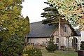
Deutsch: Verbrettertes Schrotholzhaus in Trebendorf, Kranichweg 3; um 1850; baugeschichtlich und sozialgeschichtlich von Bedeutung
English: Boarded timber wood house in Trebendorf; around 1850; of importance for architectural and social history
| (Wikidata) |
Media in category "Trebendorf, Kranichweg 3"
The following 2 files are in this category, out of 2 total.
-
 Trebendorf, Kranichweg 3 (1).jpg 6,000 × 4,000; 12.39 MB
-
 Trebendorf, Kranichweg 3 (2).jpg 6,000 × 4,000; 12.97 MB
.jpg)