Category:Trebendorf, Dorfstraße 19
Jump to navigation
Jump to search
| Object location | | View all coordinates using: OpenStreetMap |
|---|
house in Trebendorf, Germany .jpg) | |||||
| Upload media | |||||
| Instance of | |||||
|---|---|---|---|---|---|
| Location | Trebendorf, Görlitz, Saxony, Germany | ||||
| Street address |
| ||||
| Heritage designation | |||||
| Inception |
| ||||
 | |||||
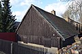
Deutsch: Schrotholzhaus eines Bauernhofs in Trebendorf, Dorfstraße 19; um 1850; Giebel verbrettert, baugeschichtlich und sozialgeschichtlich von Bedeutung
English: Timber wood house or barn of a farm in Trebendorf; around 1850; gable boarded; of importance for building history and economic social history
| (Wikidata) |
Media in category "Trebendorf, Dorfstraße 19"
This category contains only the following file.
-
 Trebendorf, Dorfstraße 19 (01).jpg 6,000 × 4,000; 12.06 MB