Category:Tram maps of France
Jump to navigation
Jump to search
Subcategories
This category has the following 30 subcategories, out of 30 total.
A
- Tram maps of Angers (9 F)
- Tram maps of Avignon (14 F)
B
- Tram maps of Besançon (3 F)
- Tram maps of Bordeaux (5 P, 31 F)
- Tram maps of Brest (France) (3 F)
C
D
- Tram maps of Dijon (2 F)
G
- Tram maps of Grenoble (8 F)
H
L
- Tram maps of Lille (21 F)
- Maps of Lyon Tram (18 F)
- Tram maps of Lyon (9 F)
M
- Tram maps of Marseille (8 F)
- Tram maps of Montpellier (24 F)
- Tram maps of Mulhouse (9 F)
N
- Tram maps of Nancy (1 F)
- Tram maps of Nantes (25 F)
O
- Tram maps of Orleans (2 F)
P
R
S
- Tram maps of Saint-Étienne (8 F)
- Tram maps of Strasbourg (27 F)
T
- Maps of Toulouse Tramway (28 F)
V
- Tram maps of Versailles (4 F)
Media in category "Tram maps of France"
The following 15 files are in this category, out of 15 total.
-
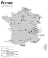
 Carte des transports urbains en France.png 1,580 × 1,556; 303 KB
-
 Elbeuf Plan du Tramway.jpg 931 × 627; 150 KB
-
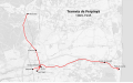
 Tramway de Fontainebleau - plan.png 800 × 700; 9 KB
-
 OePNVSystemeFrankreich-fr.png 1,204 × 1,445; 236 KB
-
 OePNVSystemeFrankreich.png 1,204 × 1,445; 165 KB
-
 Plan du Tramway de Fontainebleau.svg 992 × 778; 740 KB
-
 Plan Tramway ligne A et B Boulevard Carnot cente ville Angers .png 2,000 × 500; 521 KB
-
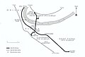
 Carte du tramway de Saint-Romain-de-Colbosc.jpg 1,342 × 968; 115 KB
-
 Localisation Tramway Saint-Romain-de-Colbosc.svg 985 × 1,403; 296 KB
-
 Tramvia Perpinyà 1909.svg 928 × 575; 972 KB
-
 Tramway Ain St Trivier Courtes Trévoux.svg 710 × 1,300; 378 KB
-
 Tramway Herrimoncourt.png 3,348 × 1,869; 2.86 MB
-
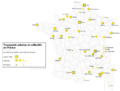
 Tramways en France en 2020.svg 2,000 × 1,922; 687 KB
-
 Transports urbains de France.png 1,072 × 811; 190 KB
-
 Tramway de Eu.jpg 1,132 × 643; 322 KB


