Category:Traffic lights at dark state
Jump to navigation
Jump to search
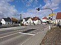
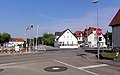
Traffic lights not in operation.
Media in category "Traffic lights at dark state"
The following 28 files are in this category, out of 28 total.
-
 4115 BÜ 5,4 Nordost.jpg 2,304 × 1,440; 1.53 MB
-
 4115 BÜ 5,4 von Nord Ost.jpg 2,304 × 1,440; 1.62 MB
-
 4115 BÜ 5,4 von Nord West.jpg 2,304 × 1,440; 1.43 MB
-
 4115 BÜ 5,4 von Süd Gehwegecke.jpg 2,304 × 1,728; 1.82 MB
-
 4115 BÜ 5,4 von West.jpg 2,304 × 1,440; 1.59 MB
-
 4115 BÜ 6,0 Ittlingen Berwanger Weg neue falsche Haltlinie.jpg 2,560 × 1,600; 1.68 MB
-
 4115 BÜ 6,0 Ittlingen FG-LSA F-Freigabe.jpg 2,560 × 1,920; 1.92 MB
-
 4115 BÜ 6,0 Ittlingen FG-LSA Nord.jpg 2,304 × 1,440; 1.46 MB
-
 4115 BÜ 6,0 Ittlingen FG-LSA Süd.jpg 2,304 × 1,440; 1.28 MB
-
 4115 BÜ 6,0 Ittlingen FG-LSA verbreiteter Gehweg.jpg 2,880 × 1,800; 2.04 MB
-
 4115 BÜ 6,0 Ittlingen FG-LSA Übersicht.jpg 2,800 × 2,100; 2.32 MB
-
 4115 BÜ 6,0 Ittlingen Zufahrt Berwanger Weg.jpg 2,304 × 1,440; 1.28 MB
-
 A63 Apr24 Lowgate Junction from Murdoch’s Connection.jpg 4,176 × 2,784; 3.38 MB
-
 Deaktivierte Ampel 20240616 HOF8635 RAW-Export.png 9,504 × 6,336; 64.97 MB
-
 Former St Joseph's School, Albany, NY.jpg 3,252 × 2,376; 3.8 MB
-
 Gesperrte Taste für Fußgängerampel 20240616 HOF8631 RAW-Export.png 9,504 × 6,336; 55.93 MB
-
 Hull city centre under flood water - geograph.org.uk - 3768391.jpg 1,024 × 681; 230 KB
-
 Hull city centre under flood water - geograph.org.uk - 3768399.jpg 1,024 × 681; 249 KB
-
 Hull city centre under flood water - geograph.org.uk - 3768407.jpg 1,024 × 681; 237 KB
-
 Hull city centre under flood water - geograph.org.uk - 3768411.jpg 1,024 × 681; 197 KB
-
 Lowgate and A63 Junction Works Overview 02, Kingston upon Hull Apr24.jpg 4,176 × 2,784; 4.14 MB
-

-
 NelsonBCBakerSt.JPG 1,600 × 1,200; 224 KB
-

-

-

-
 Stranded cars on Ferensway, Hull - geograph.org.uk - 3769120.jpg 1,024 × 681; 166 KB
-
 Traffic lights dark all-off.svg 130 × 330; 1 KB


