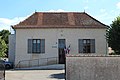
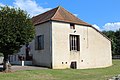
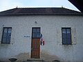
Category:Town hall of Sainte-Foy (Saône-et-Loire)
Jump to navigation
Jump to search
| Object location | | View all coordinates using: OpenStreetMap |
|---|
town hall located in Saône-et-Loire department, France  | |||||
| Upload media | |||||
| Instance of |
| ||||
|---|---|---|---|---|---|
| Location | Sainte-Foy, canton of Semur-en-Brionnais | ||||
| Street address |
| ||||
| Has use | |||||
| Owned by | |||||
| Operator | |||||
 | |||||
Media in category "Town hall of Sainte-Foy (Saône-et-Loire)"
The following 8 files are in this category, out of 8 total.
-
 Mairie Ste Foy Saône Loire 1.jpg 5,184 × 3,456; 7.7 MB
-
 Mairie Ste Foy Saône Loire 2.jpg 5,184 × 3,456; 8.44 MB
-
 Mairie Ste Foy Saône Loire 3.jpg 5,184 × 3,456; 8.55 MB
-
 Mairie Ste Foy Saône Loire 4.jpg 5,184 × 3,456; 7.35 MB
-
 Mairie Ste Foy Saône Loire 5.jpg 5,184 × 3,456; 7.13 MB
-
 Mairie Ste Foy Saône Loire 6.jpg 5,184 × 3,456; 7.72 MB
-
 Mairie Ste Foy Saône Loire 7.jpg 5,184 × 3,456; 8.5 MB
-
 SainteFoyMairie.JPG 2,304 × 1,728; 624 KB


