Category:Town hall of Courtry
Jump to navigation
Jump to search
| Object location | | View all coordinates using: OpenStreetMap |
|---|
 | |||||
| Upload media | |||||
| Instance of | |||||
|---|---|---|---|---|---|
| Location | Courtry, Seine-et-Marne, Île-de-France, Metropolitan France, France | ||||
| Street address |
| ||||
| Owned by | |||||
| Operator | |||||
 | |||||
Media in category "Town hall of Courtry"
The following 7 files are in this category, out of 7 total.
-
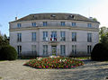 Courtry - Mairie 01.jpg 1,760 × 1,306; 301 KB
-
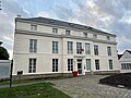
 Hôtel Ville - Courtry (FR77) - 2022-10-16 - 1.jpg 4,032 × 3,024; 3.11 MB
-
 Hôtel Ville - Courtry (FR77) - 2022-10-16 - 2.jpg 4,032 × 3,024; 3.26 MB
-
 Hôtel Ville - Courtry (FR77) - 2022-10-16 - 3.jpg 4,032 × 3,024; 3.13 MB
-
 Hôtel Ville - Courtry (FR77) - 2022-10-16 - 4.jpg 4,032 × 3,024; 2.94 MB
-
 Hôtel Ville - Courtry (FR77) - 2022-10-16 - 5.jpg 6,053 × 3,143; 14.08 MB
-
 Hôtel Ville - Courtry (FR77) - 2022-10-16 - 6.jpg 4,032 × 3,024; 2.48 MB
_-_2022-10-16_-_1.jpg)
_-_2022-10-16_-_2.jpg)
_-_2022-10-16_-_3.jpg)
_-_2022-10-16_-_4.jpg)
_-_2022-10-16_-_5.jpg)
_-_2022-10-16_-_6.jpg)