Category:Town hall of Chiry-Ourscamp
Jump to navigation
Jump to search
| Object location | | View all coordinates using: OpenStreetMap |
|---|
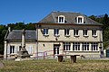
town hall located in Oise department, France ,_mairie,_rue_du_Ch%C3%A2teau_1.jpg) | |||||
| Upload media | |||||
| Instance of |
| ||||
|---|---|---|---|---|---|
| Location | Chiry-Ourscamp, canton of Ribécourt-Dreslincourt | ||||
| Street address |
| ||||
| Has use | |||||
| Owned by | |||||
| Operator | |||||
 | |||||
Media in category "Town hall of Chiry-Ourscamp"
The following 5 files are in this category, out of 5 total.
-
 Chiry-Ourscamp (60), mairie, rue du Château 1.jpg 5,184 × 3,456; 2.98 MB
-
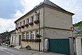
 Chiry-Ourscamp (60), mairie, rue du Château 2.jpg 5,184 × 3,456; 2.75 MB
-
 Chiry-Ourscamp mairie 1.JPG 6,000 × 4,000; 6.01 MB
-
 Chiry-Ourscamp mairie 2.JPG 6,000 × 4,000; 7.26 MB
-
 Chiry-Ourscamp mairie 3.JPG 6,000 × 4,000; 6.02 MB
,_mairie,_rue_du_Ch%C3%A2teau_2.jpg)


