Category:Town hall of Chiroubles
Jump to navigation
Jump to search
| Object location | | View all coordinates using: OpenStreetMap |
|---|
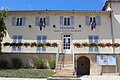
town hall located in Rhône department, France  | |||||
| Upload media | |||||
| Instance of |
| ||||
|---|---|---|---|---|---|
| Location | Chiroubles, Rhône, Auvergne-Rhône-Alpes, Metropolitan France, France | ||||
| Street address |
| ||||
| Has use | |||||
| Owned by | |||||
| Operator | |||||
 | |||||
Media in category "Town hall of Chiroubles"
The following 6 files are in this category, out of 6 total.
-
 Mairie Chiroubles 1.jpg 5,184 × 3,456; 7.48 MB
-
 Mairie Chiroubles 2.jpg 5,184 × 3,456; 7.18 MB
-
 Mairie Chiroubles 3.jpg 5,184 × 3,456; 6.63 MB
-
 Mairie Chiroubles 4.jpg 5,184 × 3,456; 7.69 MB
-
 Mairie Chiroubles 5.jpg 5,184 × 3,456; 6.98 MB
-
 Mairie Chiroubles 6.jpg 5,184 × 3,456; 7.28 MB


