Category:Town hall of Charolles
Jump to navigation
Jump to search
| Object location | | View all coordinates using: OpenStreetMap |
|---|
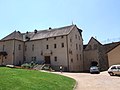
town hall located in Saône-et-Loire department, France  | |||||
| Upload media | |||||
| Instance of |
| ||||
|---|---|---|---|---|---|
| Location | Charolles, Saône-et-Loire, Bourgogne-Franche-Comté, Metropolitan France, France | ||||
| Street address |
| ||||
| Has use | |||||
| Owned by | |||||
| Operator | |||||
 | |||||
Media in category "Town hall of Charolles"
The following 9 files are in this category, out of 9 total.
-
 Charolles - Mairie.jpg 2,302 × 1,726; 1.43 MB
-
 Hôtel de ville de Charolles.jpg 3,264 × 2,448; 2.66 MB
-
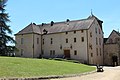 Hôtel Ville Charolles 1.jpg 5,184 × 3,456; 8.1 MB
-
 Hôtel Ville Charolles 2.jpg 5,184 × 3,456; 6.96 MB
-
 Hôtel Ville Charolles 3.jpg 5,184 × 3,456; 5.99 MB
-
 Porte Entrée Hôtel Ville Charolles 1.jpg 3,456 × 5,184; 5.34 MB
-
 Porte Entrée Hôtel Ville Charolles 2.jpg 3,456 × 5,184; 8.17 MB
-
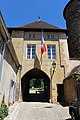 Porte Entrée Hôtel Ville Charolles 3.jpg 3,456 × 5,184; 8.24 MB
-
 Porte Entrée Hôtel Ville Charolles 4.jpg 5,033 × 6,740; 29.08 MB


