Category:Town hall of Catí
Jump to navigation
Jump to search
| Object location | | View all coordinates using: OpenStreetMap |
|---|
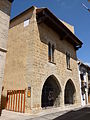
municipal building in Catí, Spain  | |||||
| Upload media | |||||
| Instance of | |||||
|---|---|---|---|---|---|
| Location | Catí, Alt Maestrat, Castellón, Valencian Community, Spain | ||||
| Architectural style | |||||
| Owned by |
| ||||
| Occupant |
| ||||
| Heritage designation |
| ||||
 | |||||
This is a category about a building listed in the Valencian heritage register as Bé de Rellevància Local (BRL) under the reference 12.02.042-010. |
Media in category "Town hall of Catí"
The following 9 files are in this category, out of 9 total.
-
 Casa de la Vila, Catí.jpg 4,608 × 3,072; 4 MB
-
 Casadelavila.jpg 369 × 240; 11 KB
-
 Cati - 003 (30591249303).jpg 3,072 × 2,304; 2.13 MB
-
 Cati - 006 (30591243563).jpg 3,072 × 2,304; 2.49 MB
-
 Town hall of Catí 01.JPG 3,456 × 4,608; 5.76 MB
-
 Town hall of Catí 02.JPG 3,456 × 4,608; 5.46 MB
-
 Town hall of Catí 03.JPG 4,608 × 3,456; 6.08 MB
-
 Town hall of Catí 04.JPG 3,456 × 4,608; 5.64 MB
-
 Town hall of Catí 05.JPG 4,608 × 3,456; 6.02 MB


.jpg)
.jpg)


