Category:Tower in Doľany, Pezinok District
Jump to navigation
Jump to search
| Object location | | View all coordinates using: OpenStreetMap |
|---|
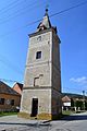
| This category shows the protected monument with the number 107-10995/0 (other) in the Slovak Republic. |
Media in category "Tower in Doľany, Pezinok District"
The following 5 files are in this category, out of 5 total.
-
 Doľany 10 01.jpg 2,304 × 3,456; 1.15 MB
-
 Doľany 10 02.jpg 2,304 × 3,456; 1.61 MB
-
 Doľany 10 03.jpg 3,456 × 2,304; 1.36 MB
-
 Doľany tower 01.JPG 2,592 × 3,872; 1.39 MB
-
 Doľany tower 02.JPG 2,592 × 3,872; 1.21 MB


