Category:Tour de la Courtine et remparts (Place de la Foire 13, Delémont)
Jump to navigation
Jump to search
| Object location | | View all coordinates using: OpenStreetMap |
|---|
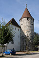
fortification in Delsberg in the canton of Jura, Switzerland  | |||||
| Upload media | |||||
| Instance of | |||||
|---|---|---|---|---|---|
| Part of | |||||
| Location | Delémont, Delémont District, Jura, Switzerland | ||||
| Street address |
| ||||
| Heritage designation | |||||
 | |||||
Media in category "Tour de la Courtine et remparts (Place de la Foire 13, Delémont)"
The following 2 files are in this category, out of 2 total.
-
 2006-Delsberg-Hotel-du-Parlement.jpg 1,920 × 1,280; 2.41 MB
-
 B-Delemont-Tour-de-la-Courtine.jpg 1,200 × 1,800; 2.08 MB
