Category:Tour Sallière
Jump to navigation
Jump to search
| Object location | | View all coordinates using: OpenStreetMap |
|---|
mountain in Switzerland   | |||||
| Upload media | |||||
| Instance of | |||||
|---|---|---|---|---|---|
| Part of | |||||
| Made from material | |||||
| Location | Salvan, Saint-Maurice District, Valais, Switzerland | ||||
| Significant event |
| ||||
| Mountain range | |||||
| Topographic prominence |
| ||||
| Topographic isolation |
| ||||
| Elevation above sea level |
| ||||
| Parent peak | |||||
 | |||||
Media in category "Tour Sallière"
The following 93 files are in this category, out of 93 total.
-
 Angry Duck - Snow Field at the Tour Sallière (19690604086).jpg 5,184 × 3,456; 6.76 MB
-
 Arête des Chaux @ Lac d'Émosson.jpg 4,608 × 3,456; 4.97 MB
-
 Arête des Chaux @ Nant de Dranse.jpg 4,608 × 3,456; 6.13 MB
-
 Arête des Chaux @ Tête du Largey.jpg 4,608 × 3,456; 4.42 MB
-
 Barrage d'Émosson - plan large.jpg 2,178 × 1,781; 653 KB
-
 Bel Oiseau @ Montagne de Barberine 02.jpg 4,608 × 3,456; 5.32 MB
-
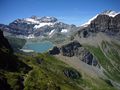
 Bel Oiseau area's sight toward "Tour Sallière" - panoramio.jpg 4,000 × 3,000; 4.75 MB
-
 Bel Oiseau's sight toward "Tour Sallière" - panoramio.jpg 4,000 × 3,000; 4.8 MB
-
 Cheval blanc's sight toward "Emosson's Dam" - panoramio.jpg 4,000 × 3,000; 4.84 MB
-
 Col de Barberine @ Veudale.jpg 4,608 × 3,456; 5.3 MB
-
 Col de la Tour Sallière @ Lac d'Émosson.jpg 4,608 × 3,456; 5.51 MB
-
 Col de la Tour Sallière @ Tête du Largey.jpg 4,608 × 3,456; 4.17 MB
-
 Col du Jorat.jpg 930 × 698; 249 KB
-
 Col du Passet.jpg 4,608 × 3,456; 7.8 MB
-
 Compton, 1909, Tour Sallière (Grand Revers) vom Glacier de Plan Névé.jpg 1,471 × 2,049; 1.19 MB
-
 Croix de Fer's sight toward Emosson's dam - panoramio.jpg 4,000 × 3,000; 4.78 MB
-
 Culan, Tour Sallière, Dents du Midi and Le Tarent (16381310460).jpg 5,184 × 3,456; 4.35 MB
-
 Emosson's area sight toward "Tour Sallière" - panoramio.jpg 4,000 × 3,000; 5.15 MB
-

-
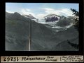
 ETH-BIB-Planachaux Susanfe-Kessel Tour Sallière-Dia 247-15264.tif 3,616 × 2,704; 28.09 MB
-
 ETH-BIB-Planachaux, Tour Sallière-Dia 247-15267.tif 3,624 × 2,692; 28 MB
-

-
 Gouille @ Col des Corbeaux.jpg 4,608 × 3,456; 6.03 MB
-
 Grand mont Ruan @ Col du Passet.jpg 4,608 × 3,456; 4.43 MB
-
 Grand mont Ruan @ Lac d'Émosson.jpg 4,608 × 3,456; 5.73 MB
-
 Grand mont Ruan @ Montagne de Barberine.jpg 4,608 × 3,456; 7.08 MB
-
 Grand mont Ruan @ Tête du Largey.jpg 4,608 × 3,456; 4.21 MB
-
 Haute Cime and Tour Sallière - panoramio.jpg 5,184 × 3,456; 4.23 MB
-
 Ice field at the Tour Sallière - panoramio.jpg 2,272 × 1,704; 1.63 MB
-
 L'Arpille's way sight to "Tour Sallière" on winter - panoramio.jpg 3,000 × 4,000; 5.12 MB
-
 L03 556 Tour Sallière, Mont Ruan.jpg 6,783 × 4,522; 6.16 MB
-
 L03 561 Tour Sallière.jpg 4,516 × 6,774; 6.73 MB
-
 La tour salliere from north.jpg 3,264 × 2,448; 3.09 MB
-
 La tour salliere north side.jpg 2,448 × 3,264; 2.96 MB
-
 Lac d'Émosson @ Col du Passet 01.jpg 4,608 × 3,456; 5.35 MB
-
 Lac de Barberine, Tour Sallières et Ruan b.jpg 1,530 × 939; 821 KB
-
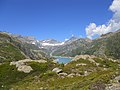
 Lac de Salanfe - panoramio (3).jpg 1,704 × 2,272; 1.16 MB
-
 Lac de Salanfe - Tour Sallière.jpg 2,592 × 1,944; 1.11 MB
-
 Lac de salanfe et la tour saliere.jpg 3,264 × 2,448; 2.55 MB
-
 Lac de Salanfe with Dents de Midi.jpg 2,048 × 1,536; 1.01 MB
-
 Lac Vert's sight toward east - panoramio.jpg 4,000 × 3,000; 4.76 MB
-
 Le Dôme (19549904390).jpg 5,184 × 3,456; 6.26 MB
-
 LesDentsBlanches-2004-07-04.jpg 960 × 720; 146 KB
-
 Luisin fontanabran tour salliere.jpg 3,264 × 2,448; 2.29 MB
-
 Mont Buet, Tour Sallière and Dents du Midi (16164301523).jpg 5,184 × 3,456; 5.8 MB
-
 Panorama de Pointe Ronde - img 00187-89.jpg 6,966 × 1,276; 2.67 MB
-
 Panoramic view in Susanfe - panoramio.jpg 3,950 × 1,785; 7.42 MB
-
 Panoramic view of the Lac de Salanfe and the Tour Sallière - panoramio.jpg 5,530 × 1,509; 9.28 MB
-
 Panoramic view on the Tour Sallière (19584385940).jpg 13,718 × 3,949; 53.77 MB
-
 Panoramic view on the Tour Sallière - panoramio.jpg 11,787 × 3,393; 9.36 MB
-
 Pic de Tenneverge @ Cheval Blanc.jpg 4,608 × 3,456; 3.93 MB
-
 Pic de Tenneverge Tour Sallière @ Arête orientale Cheval Blanc.jpg 4,608 × 3,456; 4.95 MB
-
 Pointe de la Finive's sight to "Mt Ruan" - panoramio.jpg 4,000 × 3,000; 4.99 MB
-
 Pointe de la Finive's sight toward "Mt Ruan" - panoramio.jpg 4,000 × 3,000; 4.86 MB
-
 Pointe de la Finive's sighte toward "Tour Sallière" - panoramio.jpg 3,000 × 4,000; 4.99 MB
-
 Pointes d'Aboillon.jpg 3,264 × 2,448; 5.02 MB
-
 Refuge des dents du midi sight toward west - panoramio.jpg 1,200 × 803; 331 KB
-

-
 Rochers Rouges @ Lac d'Émosson.jpg 4,608 × 3,456; 4.99 MB
-
 Rocks near the Col de Susanfe - panoramio (2).jpg 2,272 × 1,704; 1.36 MB
-
 Salanfe panorama.jpg 2,592 × 1,036; 808 KB
-
 Salanfe's lake sight to "La Tour Sallière" - panoramio.jpg 4,000 × 3,000; 4.76 MB
-
 Sallière.jpg 4,000 × 3,000; 2.35 MB
-
 Scenic view from the Haute Cime - panoramio (6).jpg 2,272 × 1,704; 1.06 MB
-
 Tour de Prazon @ Col du Passet.jpg 4,608 × 3,456; 4.66 MB
-
 Tour de Prazon @ Tête du Largey.jpg 4,608 × 3,456; 4.31 MB
-
 Tour Salière et lac de Salanfe.jpg 2,592 × 1,944; 1.89 MB
-
 Tour Salliere and Dents du Midi (14988131594).jpg 5,184 × 3,456; 5.48 MB
-
 Tour salliere on right and Fontanabran center.jpg 3,264 × 2,448; 2.61 MB
-
 Tour Sallière (16360958177).jpg 5,184 × 3,456; 3.69 MB
-
 Tour Sallière (16803153955).jpg 5,184 × 3,456; 4.61 MB
-
 Tour Sallière @ Cheval Blanc.jpg 4,608 × 3,456; 3.97 MB
-
 Tour Sallière @ Col du Passet.jpg 4,608 × 3,456; 4.79 MB
-
 Tour Sallière @ Lac d'Émosson.jpg 4,608 × 3,456; 5.05 MB
-
 Tour Sallière @ Montagne de Barberine.jpg 4,608 × 3,456; 6.55 MB
-
 Tour Sallière @ Nant de Dranse.jpg 4,608 × 3,456; 6.55 MB
-
 Tour Sallière @ Tête du Largey.jpg 4,608 × 3,456; 4.29 MB
-
 Tour Sallière @ Veudale.jpg 4,608 × 3,456; 5.49 MB
-
 Tour Sallière at dawn - panoramio.jpg 2,272 × 1,704; 684 KB
-
 Tour Sallière at sunrise - panoramio.jpg 2,272 × 1,704; 916 KB
-
 Tour Sallière seen from the Haute cime (19747672115).jpg 5,184 × 3,456; 5.34 MB
-

-
 Tour Sallière.jpg 2,592 × 1,944; 1.13 MB
-
 Tour Sallière.png 418 × 335; 192 KB
-
 TourSallière.jpg 2,048 × 1,536; 811 KB
-
 Tête du Grenairon @ Cheval Blanc.jpg 4,608 × 3,456; 5.5 MB
-
 Vallon de Susanfe - img 26776.jpg 4,080 × 2,720; 4.44 MB
-
 View down from the path to the Haute Cime - panoramio (3).jpg 1,704 × 2,272; 1.32 MB
-
 View down from the path to the Haute Cime - panoramio.jpg 1,704 × 2,272; 1.25 MB
-
 View from near the Col de Paresseux - panoramio.jpg 1,704 × 2,272; 1.12 MB
-
 View onto the Tour Sallière from Pts Perrons - panoramio (1).jpg 2,272 × 1,704; 1.21 MB
-
 View onto the Tour Sallière from Pts Perrons - panoramio.jpg 1,704 × 2,272; 1.09 MB
-
 View south from the Col de Susanfe - panoramio.jpg 2,272 × 1,704; 1.23 MB
.jpg)


_vom_Glacier_de_Plan_N%C3%A9v%C3%A9.jpg)

.jpg)


.jpg)


.jpg)


.jpg)


.jpg)


.jpg)


.jpg)

.jpg)
.jpg)


.jpg)
.jpg)


.jpg)


.jpg)


.jpg)