Category:Tossens range front
Jump to navigation
Jump to search
| Object location | | View all coordinates using: OpenStreetMap |
|---|
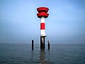
lighthouse in Lower Saxony, Germany  | |||||
| Upload media | |||||
| Instance of | |||||
|---|---|---|---|---|---|
| Part of | |||||
| Made from material | |||||
| Location | Wesermarsch, Lower Saxony, Germany | ||||
| Located in or next to body of water | |||||
| Inception |
| ||||
| Height |
| ||||
 | |||||
Media in category "Tossens range front"
The following 5 files are in this category, out of 5 total.
-
 2012-05-13 Nordsee-Luftbilder DSCF8584.JPG 2,848 × 4,256; 4.28 MB
-
 2012-05-13 Nordsee-Luftbilder DSCF8587.JPG 2,848 × 4,256; 4.29 MB
-
 Tossens range front 7498.jpg 2,432 × 1,824; 758 KB
-
 Tossens range front 7499.jpg 2,498 × 1,874; 777 KB
-
 Tossens range front 7500.jpg 2,590 × 1,944; 755 KB


