Category:Torsåkers kyrka, Ångermanland
Jump to navigation
Jump to search
Svenska: Torsåkers kyrka tillhör Torsåkers församling, Härnösand-Kramfors kontrakt, Härnösands stift / Diocese of Härnösand.
| Object location | | View all coordinates using: OpenStreetMap |
|---|
|
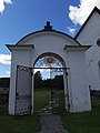
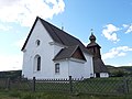
This is a category about an ecclesiastical monument in Sweden, number 21300000004415 in the RAÄ buildings database.
|
church building in Kramfors Municipality, Sweden   | |||||
| Upload media | |||||
| Instance of | |||||
|---|---|---|---|---|---|
| Location | Kramfors Municipality, Västernorrland County, Sweden | ||||
| Diocese | |||||
| Connects with | |||||
| Has use |
| ||||
| Occupant |
| ||||
| Heritage designation |
| ||||
| Different from | |||||
 | |||||
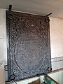
Media in category "Torsåkers kyrka, Ångermanland"
The following 20 files are in this category, out of 20 total.
-
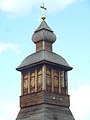
 Torsåkers klockstapel, Härnösands stift.JPG 3,072 × 4,608; 4.23 MB
-
 Torsåkers kyrka Ångermanland 01.jpg 4,032 × 3,024; 2.68 MB
-
 Torsåkers kyrka Ångermanland 02.jpg 4,032 × 3,024; 2.8 MB
-
 Torsåkers kyrka Ångermanland 03.jpg 3,024 × 4,032; 2.68 MB
-
 Torsåkers kyrka Ångermanland 04.jpg 4,032 × 3,024; 2.51 MB
-
 Torsåkers kyrka Ångermanland 05.jpg 4,032 × 3,024; 3.42 MB
-
 Torsåkers kyrka Ångermanland 06.jpg 3,864 × 5,152; 3.91 MB
-
 Torsåkers kyrka Ångermanland 07.jpg 4,032 × 3,024; 2.43 MB
-
 Torsåkers kyrka Ångermanland 08.jpg 3,024 × 4,032; 5.16 MB
-
 Torsåkers kyrka Ångermanland 09.jpg 3,024 × 4,032; 5.27 MB
-
 Torsåkers kyrka Ångermanland 10.jpg 4,032 × 3,024; 5.64 MB
-
 Torsåkers kyrka Ångermanland 11.jpg 3,024 × 4,032; 4.7 MB
-
 Torsåkers kyrka Ångermanland 12.jpg 3,024 × 4,032; 4.53 MB
-
 Torsåkers kyrka Ångermanland 13.jpg 4,032 × 3,024; 4.07 MB
-
 Torsåkers kyrka Ångermanland 14.jpg 4,032 × 3,024; 4.87 MB
-
 Torsåkers kyrka Ångermanland 15.jpg 3,024 × 4,032; 4.56 MB
-
 Torsåkers kyrka Ångermanland 16.jpg 3,024 × 4,032; 4.1 MB
-
 Torsåkers kyrka Ångermanland 17.jpg 3,024 × 4,032; 4.56 MB
-
 Torsåkers kyrka, Härnösands stift.JPG 4,608 × 3,072; 4.9 MB
-
 Torsåkers kyrka, Ångermanland.JPG 4,608 × 3,072; 6.5 MB


Categories:
- Churches in Kramfors Municipality
- Churches in the Diocese of Härnösand
- Churches in Ångermanland
- Gothic stone churches in Västernorrland County
- 15th-century churches in Västernorrland County
- 1790s churches in Västernorrland County
- Churches in Sweden built in 1793
- Prästmon
- Torsåker, Ångermanland
- Listed churches in Kramfors Municipality
- White churches in Sweden
- Aisleless churches in Sweden