Category:Torrent des Glaciers
Jump to navigation
Jump to search
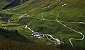
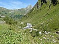
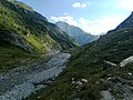
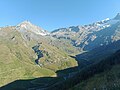
 Vue du torrent des Glaciers dans la vallée des Chapieux avec au fond le col de la Croix du Bonhomme et la tête Sud des Fours. | |||||
| Upload media | |||||
| Instance of |
| ||||
|---|---|---|---|---|---|
| Location | |||||
| Length |
| ||||
| Elevation above sea level |
| ||||
| Origin of the watercourse | |||||
| Mouth of the watercourse |
| ||||
| Drainage basin |
| ||||
 | |||||
Media in category "Torrent des Glaciers"
The following 21 files are in this category, out of 21 total.
-
 Alpes 2017-07-27 (23582610188).jpg 6,000 × 3,546; 2.71 MB
-
 Alpes 2017-07-27 (23593864008).jpg 6,000 × 2,832; 2.4 MB
-
 Ancien barrage vallée des Glaciers.jpg 4,608 × 3,456; 9.21 MB
-
 Barrage de Seloge.jpg 4,608 × 3,456; 6.77 MB
-
 Barrage de Seloge1.jpg 4,608 × 3,456; 6.9 MB
-
 Fortifications de Seloge4.jpg 4,608 × 3,456; 9.97 MB
-
 La route vers bourg st maurice et le torrent des glaciers - panoramio.jpg 1,408 × 864; 615 KB
-
 Le torrent des glaciers a bourg st maurice - panoramio (1).jpg 4,000 × 3,000; 4.91 MB
-
 Le torrent des glaciers a bourg st maurice - panoramio (2).jpg 2,720 × 864; 1.14 MB
-
 Le torrent des glaciers a bourg st maurice - panoramio (3).jpg 4,000 × 3,000; 4.82 MB
-
 Le torrent des glaciers a bourg st maurice - panoramio.jpg 4,000 × 3,000; 4.91 MB
-
 Les Chapieux Chalets de la Raja.jpg 4,608 × 3,456; 7.79 MB
-
 Les Chapieux Pointe de la Terrasse Chalets de la Raja.jpg 4,608 × 3,456; 6.22 MB
-
 Mont Tondu Col de la Seigne.jpg 4,608 × 3,456; 5.33 MB
-
 Passerelle Vallée des Glaciers.jpg 4,608 × 3,456; 8.8 MB
-
 Retenue de Seloge.jpg 4,608 × 3,456; 7.13 MB
-
 Torrent des Glaciers Pointe de la Terrasse.jpg 4,608 × 3,456; 6.01 MB
-
 Torrent des Glaciers.jpg 3,456 × 4,608; 8.86 MB
-
 Val des Glaciers Les Mottets.jpg 4,608 × 3,456; 4.8 MB
-
 Vallée des Chapieux Pointe de la Terrasse Chalet du Petit Mont-Blanc.jpg 4,608 × 3,456; 6.8 MB
-
 Vallée des Glaciers Barrage de Seloge.jpg 4,608 × 3,456; 6.1 MB
.jpg)
.jpg)


.jpg)
.jpg)


.jpg)