Category:Torenberg (Zaamslag)
Jump to navigation
Jump to search
| Object location | | View all coordinates using: OpenStreetMap |
|---|
castle in Zeelandic Flanders, the Netherlands  | |||||
| Upload media | |||||
| Instance of | |||||
|---|---|---|---|---|---|
| Location | Terneuzen, Zeeland, Netherlands | ||||
| Street address |
| ||||
| Heritage designation |
| ||||
 | |||||
|
This is a category about rijksmonument number 46044
|
| Address |
|
Media in category "Torenberg (Zaamslag)"
The following 9 files are in this category, out of 9 total.
-
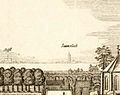
 De Torenberg in 1569.jpg 1,286 × 859; 666 KB
-
 Entreezuil Torenhoeve te Zaamslag.jpg 1,536 × 2,560; 2.13 MB
-
 Hekpaal Torenhoeve en reconstructie kasteel in Zaamslag.jpg 2,560 × 1,536; 1.93 MB
-
 Historisch wapenschild, historische entree en kasteelreconstructie in Zaamslag.jpg 2,560 × 1,536; 2.15 MB
-
 Muurfragment Torenberg Zaamslag.jpg 447 × 312; 107 KB
-
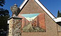
 Reconstructieplaat kasteel Zaamslag rond 1400.jpg 2,560 × 1,536; 1.89 MB
-
 Torenberg nu.JPG 177 × 266; 13 KB
-
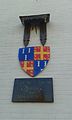 Wapenschild van de kasteelheren van Zaamslag.jpg 1,536 × 2,560; 1.38 MB
-
 Zaamslag rond 1660.jpg 1,248 × 990; 605 KB


