Category:Topographic maps of volcanoes in Indonesia
Jump to navigation
Jump to search
Subcategories
This category has only the following subcategory.
Media in category "Topographic maps of volcanoes in Indonesia"
The following 20 files are in this category, out of 20 total.
-
 Bali Mts Agung and Batur.jpg 1,400 × 704; 106 KB
-
 Bali sund och öar.png 2,104 × 1,725; 2.13 MB
-
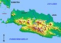 Batavia-Bandung.jpg 848 × 598; 101 KB
-
 Bengawan Solo topography map.png 800 × 481; 402 KB
-
 Dieng plateau Relief Map, SRTM-1.jpg 1,200 × 900; 853 KB
-
 Galunggung Relief Map, SRTM-1.jpg 1,600 × 1,200; 1.17 MB
-
 Ijen-Umgebung.JPG 1,511 × 1,508; 668 KB
-
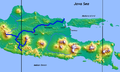
 Java-Vulkane.jpg 2,380 × 1,804; 873 KB
-
 Lake Toba (SRTM).jpg 1,800 × 1,200; 1.46 MB
-
 Lombok Locator Topography.png 2,003 × 2,037; 1.93 MB
-
 Lombok Topography (labelled).png 2,003 × 2,037; 2.16 MB
-
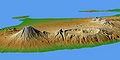
 Mount Ceremai Relief Map, SRTM-1.jpg 1,000 × 750; 576 KB
-
 Mount Gede Relief Map, SRTM-1.jpg 1,200 × 900; 890 KB
-
 Mount Slamet Relief Map, SRTM-1.jpg 1,000 × 750; 675 KB
-
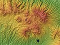
 Mount Sundoro & Mount Sumbing Relief Map, SRTM-1.jpg 1,600 × 1,200; 1.52 MB
-
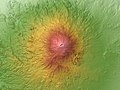
 Mount Tambora Relief Map, SRTM-1.jpg 1,600 × 1,200; 992 KB
-
 Taman Nasional Gunung Merapi peta topografi id.svg 826 × 575; 1.15 MB
-
 Tangkuban Perahu Relief Map, SRTM-1.jpg 1,600 × 1,200; 1.44 MB
-
 Topography of Bali-SUBAK.jpg 1,576 × 1,076; 238 KB
-
 Vom Krakatau bis zum Tambora.jpg 3,994 × 1,707; 1.24 MB


.jpg)

.png)


