Category:Topographic maps of volcanoes in Canada
Jump to navigation
Jump to search
Media in category "Topographic maps of volcanoes in Canada"
The following 7 files are in this category, out of 7 total.
-
 Anahim Volcanic Belt-en.svg 2,334 × 832; 723 KB
-
 Far Mountain topo.jpg 1,484 × 2,004; 1.49 MB
-
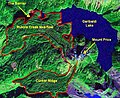 Garibaldi Lake area map.jpg 574 × 468; 81 KB
-
 Garibaldi Volcanic Belt-en.svg 2,200 × 1,700; 1.9 MB
-
 Hoodoo Mountain topo (1).jpg 3,195 × 1,776; 1.24 MB
-
 Level Mountain 3D topo.jpg 4,080 × 2,121; 1.33 MB
-
 Level Mountain topo.jpg 3,949 × 2,121; 2.06 MB


.jpg)

