Category:Topographic maps of Japan by series (maps-for-free.com)
Jump to navigation
Jump to search
- Files from maps-for-free.com [1] by Hans Braxmeier
Media in category "Topographic maps of Japan by series (maps-for-free.com)"
The following 16 files are in this category, out of 16 total.
-
 Abukuma Mountains.png 948 × 1,602; 3.23 MB
-
 Geofeatures map of Chubu Japan ja.svg 1,080 × 1,200; 4.26 MB
-
 Geofeatures map of Chugoku Japan ja.svg 1,500 × 900; 3.76 MB
-
 Geofeatures map of Kansai Japan ja.svg 1,100 × 1,100; 3.86 MB
-
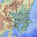 Geofeatures map of Kanto Japan ja.svg 700 × 700; 1.94 MB
-
 Geofeatures map of Shikoku Japan ja.svg 1,246 × 960; 2.95 MB
-
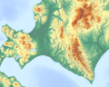 Hokkaido Central topographic map.png 1,277 × 1,024; 2.04 MB
-
 Hokkaido North and Central topographic map.png 1,080 × 1,350; 1.8 MB
-
 Hokkaido South topographic map.png 1,153 × 841; 995 KB
-
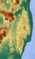
 Location map Ryukyu Islands.png 1,457 × 893; 797 KB
-
 Reliefmap of Japan.png 561 × 659; 496 KB
-
 Shiribeshitoshibetsu River.png 713 × 649; 1.02 MB
-
 Topographic map of Kyushu.png 2,285 × 2,285; 7.32 MB
-
 Toyama Bay.png 1,082 × 842; 939 KB
-
 Wakasa Bay topographic map.png 1,589 × 1,080; 1.59 MB
-
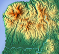
 久万高原周辺.jpg 859 × 861; 324 KB


