Category:Topographic maps of Indian states and union territories
Jump to navigation
Jump to search
Subcategories
This category has only the following subcategory.
Media in category "Topographic maps of Indian states and union territories"
The following 10 files are in this category, out of 10 total.
-
 58E.1.jpg 4,300 × 4,300; 7.83 MB
-
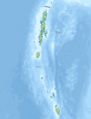 India Andaman and Nicobar Islands relief map.png 567 × 744; 160 KB
-
 India Arunachal Pradesh relief map.png 1,456 × 800; 1.96 MB
-
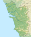 India Goa relief map.png 601 × 726; 607 KB
-
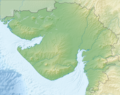 India Gujarat relief map.png 1,085 × 861; 1.2 MB
-
 India Jammu and Kashmir relief map.png 950 × 958; 1.31 MB
-
 India Jharkhand relief map.png 854 × 712; 867 KB
-
 India Kerala relief map.png 828 × 1,205; 933 KB
-
 India Nagaland relief map.png 545 × 565; 378 KB
-
 India Tamil Nadu relief map.png 1,989 × 2,469; 4.26 MB


