Category:Topographic maps of German low mountain ranges (Mittelgebirge), A series
Jump to navigation
Jump to search

Topographic maps of German low mountain ranges (A series)
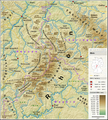
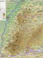
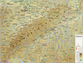
This map series aims to show the major low mountain ranges of Germany in a uniform design. All maps are created on the same scale, and the background reliefs base upon the same color scheme. The reliefs are also available as separate files.
This series is under development and not yet completed.
Pages in category "Topographic maps of German low mountain ranges (Mittelgebirge), A series"
This category contains only the following page.
Media in category "Topographic maps of German low mountain ranges (Mittelgebirge), A series"
The following 50 files are in this category, out of 50 total.
-
 Bayerischer Wald (Relief und Gewässer) - Deutsche Mittelgebirge, Serie A-de.png 3,100 × 2,000; 8.21 MB
-
 Bayerischer Wald (Relief) - Deutsche Mittelgebirge, Serie A-de.png 3,100 × 2,000; 7.34 MB
-
 Bayerischer Wald - Deutsche Mittelgebirge, Serie A-de.png 3,100 × 2,000; 8.99 MB
-
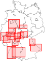 Deutsche Mittelgebirge, Serie A - Abdeckung.svg 209 × 282; 126 KB
-
 Eifel (Relief und Gewässer) - Deutsche Mittelgebirge, Serie A-de.png 2,500 × 2,600; 9.95 MB
-
 Eifel (Relief) - Deutsche Mittelgebirge, Serie A-de.png 2,500 × 2,600; 9.15 MB
-
 Eifel - Deutsche Mittelgebirge, Serie A-de.png 2,500 × 2,600; 9.83 MB
-
 Harz (Relief und Gewässer) - Deutsche Mittelgebirge, Serie A-de.png 2,450 × 1,300; 4.36 MB
-
 Harz (Relief) - Deutsche Mittelgebirge, Serie A-de.png 2,450 × 1,300; 4.02 MB
-
 Harz - Deutsche Mittelgebirge, Serie A-de.png 2,450 × 1,300; 4.46 MB
-
 Hunsrück (Relief und Gewässer) - Deutsche Mittelgebirge, Serie A-de.png 2,100 × 2,100; 6.16 MB
-
 Hunsrück (Relief) - Deutsche Mittelgebirge, Serie A-de.png 2,100 × 2,100; 5.79 MB
-
 Hunsrück - Deutsche Mittelgebirge, Serie A-de.png 2,100 × 2,100; 6.53 MB
-
 Oberpfälzer Wald (Relief und Gewässer) - Deutsche Mittelgebirge, Serie A-de.png 1,800 × 2,050; 4.87 MB
-
 Oberpfälzer Wald (Relief) - Deutsche Mittelgebirge, Serie A-de.png 1,800 × 2,050; 4.49 MB
-
 Oberpfälzer Wald - Deutsche Mittelgebirge, Serie A-de.png 1,800 × 2,050; 6.55 MB
-
 Odenwald (Relief und Gewässer) - Deutsche Mittelgebirge, Serie A-de.png 1,800 × 1,650; 4.23 MB
-
 Odenwald (Relief) - Deutsche Mittelgebirge, Serie A-de.png 1,800 × 1,650; 3.94 MB
-
 Odenwald - Deutsche Mittelgebirge, Serie A-de.png 1,800 × 1,650; 4.36 MB
-
 Rhön (Relief und Gewässer) - Deutsche Mittelgebirge, Serie A-de.png 1,800 × 2,000; 4.61 MB
-
 Rhön (Relief) - Deutsche Mittelgebirge, Serie A-de.png 1,800 × 2,000; 4.23 MB
-
 Rhön - Deutsche Mittelgebirge, Serie A-de.png 1,800 × 2,000; 4.92 MB
-
 Rothaargebirge (Relief und Gewässer) - Deutsche Mittelgebirge, Serie A-de.png 2,000 × 1,600; 4.98 MB
-
 Rothaargebirge (Relief) - Deutsche Mittelgebirge, Serie A-de.png 2,000 × 1,600; 4.1 MB
-
 Rothaargebirge - Deutsche Mittelgebirge, Serie A-de.png 2,000 × 1,600; 4.59 MB
-
 Schwarzwald (Relief und Gewässer) - Deutsche Mittelgebirge, Serie A-de.png 2,500 × 3,400; 11.69 MB
-
 Schwarzwald (Relief) - Deutsche Mittelgebirge, Serie A-de.png 2,500 × 3,400; 10.84 MB
-
 Schwarzwald - Deutsche Mittelgebirge, Serie A-de.png 2,500 × 3,400; 12.29 MB
-
 Schwäbische Alb (Relief und Gewässer) - Deutsche Mittelgebirge, Serie A-de.png 3,500 × 2,650; 12.61 MB
-
 Schwäbische Alb (Relief) - Deutsche Mittelgebirge, Serie A-de.png 3,500 × 2,650; 11.63 MB
-
 Schwäbische Alb - Deutsche Mittelgebirge, Serie A-de.png 3,500 × 2,650; 13.05 MB
-
 Spessart (Relief und Gewässer) - Deutsche Mittelgebirge, Serie A-de.png 1,600 × 1,600; 3.57 MB
-
 Spessart (Relief) - Deutsche Mittelgebirge, Serie A-de.png 1,600 × 1,600; 3.31 MB
-
 Spessart - Deutsche Mittelgebirge, Serie A-de.png 1,600 × 1,600; 3.67 MB
-
 Taunus (Relief und Gewässer) - Deutsche Mittelgebirge, Serie A-de.png 2,300 × 1,500; 4.86 MB
-
 Taunus (Relief) - Deutsche Mittelgebirge, Serie A-de.png 2,300 × 1,500; 4.54 MB
-
 Taunus - Deutsche Mittelgebirge, Serie A-de.png 2,300 × 1,500; 5.05 MB
-
 Teutoburger Wald (Relief und Gewässer) - Deutsche Mittelgebirge, Serie A-de.png 3,250 × 2,450; 12.23 MB
-
 Teutoburger Wald (Relief) - Deutsche Mittelgebirge, Serie A-de.png 3,250 × 2,450; 11.67 MB
-
 Teutoburger Wald - Deutsche Mittelgebirge, Serie A-de.png 3,250 × 2,450; 12.42 MB
-
 Thüringer Wald (Relief und Gewässer) - Deutsche Mittelgebirge, Serie A-de.png 2,200 × 1,850; 5.15 MB
-
 Thüringer Wald (Relief) - Deutsche Mittelgebirge, Serie A-de.png 2,200 × 1,850; 4.8 MB
-
 Thüringer Wald - Deutsche Mittelgebirge, Serie A-de.png 2,200 × 1,850; 5.3 MB
-
 Topografische Karte der Ahr.PNG 1,672 × 909; 3.22 MB
-
 Vogelsberg (Relief und Gewässer) - Deutsche Mittelgebirge, Serie A-de.png 2,000 × 1,650; 4.23 MB
-
 Vogelsberg (Relief) - Deutsche Mittelgebirge, Serie A-de.png 2,000 × 1,650; 3.85 MB
-
 Vogelsberg - Deutsche Mittelgebirge, Serie A-de.png 2,000 × 1,650; 4.48 MB
-
 Westerwald (Relief und Gewässer) - Deutsche Mittelgebirge, Serie A-de.png 2,750 × 1,450; 5.59 MB
-
 Westerwald (Relief) - Deutsche Mittelgebirge, Serie A-de.png 2,750 × 1,450; 5.18 MB
-
 Westerwald - Deutsche Mittelgebirge, Serie A-de.png 2,750 × 1,450; 5.96 MB
_-_Deutsche_Mittelgebirge,_Serie_A-de.png)
_-_Deutsche_Mittelgebirge,_Serie_A-de.png)

_-_Deutsche_Mittelgebirge,_Serie_A-de.png)
_-_Deutsche_Mittelgebirge,_Serie_A-de.png)

_-_Deutsche_Mittelgebirge,_Serie_A-de.png)
_-_Deutsche_Mittelgebirge,_Serie_A-de.png)

_-_Deutsche_Mittelgebirge,_Serie_A-de.png)
_-_Deutsche_Mittelgebirge,_Serie_A-de.png)

_-_Deutsche_Mittelgebirge,_Serie_A-de.png)
_-_Deutsche_Mittelgebirge,_Serie_A-de.png)

_-_Deutsche_Mittelgebirge,_Serie_A-de.png)
_-_Deutsche_Mittelgebirge,_Serie_A-de.png)

_-_Deutsche_Mittelgebirge,_Serie_A-de.png)
_-_Deutsche_Mittelgebirge,_Serie_A-de.png)

_-_Deutsche_Mittelgebirge,_Serie_A-de.png)
_-_Deutsche_Mittelgebirge,_Serie_A-de.png)

_-_Deutsche_Mittelgebirge,_Serie_A-de.png)
_-_Deutsche_Mittelgebirge,_Serie_A-de.png)

_-_Deutsche_Mittelgebirge,_Serie_A-de.png)
_-_Deutsche_Mittelgebirge,_Serie_A-de.png)

_-_Deutsche_Mittelgebirge,_Serie_A-de.png)
_-_Deutsche_Mittelgebirge,_Serie_A-de.png)

_-_Deutsche_Mittelgebirge,_Serie_A-de.png)
_-_Deutsche_Mittelgebirge,_Serie_A-de.png)

_-_Deutsche_Mittelgebirge,_Serie_A-de.png)
_-_Deutsche_Mittelgebirge,_Serie_A-de.png)

_-_Deutsche_Mittelgebirge,_Serie_A-de.png)
_-_Deutsche_Mittelgebirge,_Serie_A-de.png)


_-_Deutsche_Mittelgebirge,_Serie_A-de.png)
_-_Deutsche_Mittelgebirge,_Serie_A-de.png)

_-_Deutsche_Mittelgebirge,_Serie_A-de.png)
_-_Deutsche_Mittelgebirge,_Serie_A-de.png)
