Category:Tongass Narrows
Jump to navigation
Jump to search
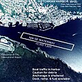
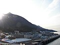
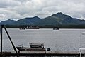
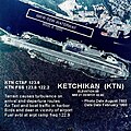
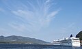
English: Tongass Narrows is a strait in southeast Alaska that separates Revillagigedo Island (not to be confused with the Revillagigedo Islands in Mexico) from Gravina Island. The strait connects to Clarence Strait in the northwest and Nichols Passage in the southeast. The city of Ketchikan, Alaska is on the strait with most of the city on the northeast (Revillagigedo Island) side while Ketchikan International Airport is on the southwest (Gravina Island).
channel in southeastern Alaska, United States | |||||
| Upload media | |||||
| Instance of | |||||
|---|---|---|---|---|---|
| Location | Ketchikan Gateway Borough, Alaska | ||||
 | |||||
Subcategories
This category has the following 2 subcategories, out of 2 total.
P
Media in category "Tongass Narrows"
The following 20 files are in this category, out of 20 total.
-
 5KE-a.jpg 500 × 498; 97 KB
-
 A Ketchican, Alaska ferry -a.jpg 1,136 × 852; 158 KB
-
 Alaska Marine Highway- Departing Ketchikan, Alaska - 7602183984.jpg 4,752 × 3,168; 4.54 MB
-
 Deer Mtn panorama.jpg 7,545 × 1,040; 4.59 MB
-
 Gravina Island from Ketchikan, Alaska.jpg 3,072 × 2,304; 2.13 MB
-
 Ketchikan from Tongass Narrows, Alaska 2.jpg 3,072 × 2,304; 1.54 MB
-
 Ketchikan from Tongass Narrows, Alaska 3.jpg 3,072 × 2,304; 2.07 MB
-
 Ketchikan from Tongass Narrows, Alaska.jpg 3,072 × 2,304; 1.56 MB
-
 Ketchikan, AK - waterfront along Water Street 02.jpg 6,000 × 4,000; 9.51 MB
-
 Ketchikan, Alaska - panoramio - karlee ladyk (4).jpg 2,592 × 1,944; 1.23 MB
-
 KTN-b.jpg 396 × 396; 56 KB
-
 Maof LH Reserve - NARA - 77415432.jpg 3,128 × 3,673; 2.8 MB
-
 Norwegian Star in Ketchikan, Alaska 2.jpg 3,072 × 2,304; 2.24 MB
-
 Norwegian Star in Ketchikan, Alaska.jpg 3,072 × 2,304; 2.1 MB
-
 Tongass Narrows - panoramio - karlee ladyk (12).jpg 2,592 × 1,944; 1.11 MB
-
 Tongass Narrows and Norwegian Star from Ketchikan, Alaska cropped.jpg 3,070 × 1,835; 1.55 MB
-
 Tongass Narrows and Norwegian Star from Ketchikan, Alaska.jpg 3,072 × 2,304; 2.16 MB
-
 Tongass Narrows ENBLA01.jpg 8,688 × 5,792; 7.14 MB
-
 Tongass Narrows ENBLA02.jpg 8,688 × 5,792; 4.21 MB
-
 Txu-pclmaps-topo-us-ketchikan-1954 (Tongass Narrows).jpg 1,024 × 775; 325 KB


.jpg)


.jpg)


.jpg)