Category:Tin tabernacles in England
Jump to navigation
Jump to search
Subcategories
This category has the following 66 subcategories, out of 66 total.
A
- Alhampton Mission Church (3 F)
B
- St Mary and St Felix, Babingley (15 F)
- Bartley Village Hall (26 F)
- St Peter's Church, Beech (27 F)
- Blackgang Mission Hall (7 F)
- Blists Hill tin tabernacle (7 F)
- Church in the Woods, Bramdean (29 F)
- Brethren Meeting Room, Liss (8 F)
C
- St Aidan's Church, Caythorpe (4 F)
- Christchurch, Pointon (4 F)
- Clara Vale Methodist Church (4 F)
- St Hugh's Church, Cockernhoe (5 F)
D
- St Saviour's Church, Dottery (7 F)
E
- Edithmead Mission Church (7 F)
F
G
- St Francis' Church, Gosport (14 F)
H
- Halse Mission (3 F)
- St Michael's Church, Hythe, Kent (21 F)
K
- Kemble Methodist Church (3 F)
- Knowle Mission Room (2 F)
L
- St Saviour, Liss Forest (2 F)
- Luckington Methodist Church (9 F)
M
- St Mary's Church, Cadgwith (5 F)
N
P
R
- Reigate Heath Church (3 F)
- St Saviour's Church, Rookery (2 F)
- St John's Church, Rookley (6 F)
S
- St Barnabas' Church, Kenilworth (11 F)
- St Mary's Room, Sole Street (3 F)
- St Paul's Church, Strines (3 F)
T
- Tin Mission Church (15 F)
Media in category "Tin tabernacles in England"
The following 93 files are in this category, out of 93 total.
-
 'Tin Chapel' Church Lane, Ripon - geograph.org.uk - 624038.jpg 640 × 484; 105 KB
-
 A Strange Building - geograph.org.uk - 1245354.jpg 640 × 480; 107 KB
-
 Betton church - geograph.org.uk - 1176321.jpg 640 × 480; 117 KB
-
 Birdwood Mission Church - geograph.org.uk - 155495.jpg 640 × 480; 64 KB
-
 Bramshill Mission Church - geograph.org.uk - 1482691.jpg 640 × 451; 129 KB
-
 Breadstone (Glos) St Michael's Church - geograph.org.uk - 68146.jpg 640 × 480; 71 KB
-

-

-
 Chapel, Dunsdale.jpg 640 × 384; 55 KB
-
 Chiltern Open Air Museum Henton Mission.jpg 2,436 × 1,572; 2.7 MB
-
 Chilworth Village Hall (former Mission Church), New Road, Chilworth (March 2014).JPG 3,600 × 2,400; 1.42 MB
-
 Chobham Gospel Hall - geograph.org.uk - 308560.jpg 640 × 594; 141 KB
-

-

-
 Church of St Francis, Westhope - geograph.org.uk - 672951.jpg 640 × 480; 94 KB
-
 Church of St Thomas, Gristhorpe - geograph.org.uk - 1310388.jpg 640 × 480; 70 KB
-
 Spiritualist Church - geograph.org.uk - 710594.jpg 640 × 480; 82 KB
-
 Coombe Green Mission Room - geograph.org.uk - 3635.jpg 640 × 479; 42 KB
-
 Coombe Green Mission Room - geograph.org.uk - 722630.jpg 640 × 426; 80 KB
-
 Edge End Methodist Church - geograph.org.uk - 1044981.jpg 640 × 480; 142 KB
-

-
 Former Free (Baptist) Church (a.k.a. Mission Hall), Barnett Wood Lane, Ashtead.JPG 1,800 × 1,400; 419 KB
-
 Former St John's Church, Summerfield - geograph.org.uk - 1622413.jpg 640 × 426; 73 KB
-
 Former St Saviour's Church, Chiddingstone Causeway.JPG 2,592 × 1,944; 1.55 MB
-
 Former St Stephen's Mission Church, Lower Haysden.JPG 1,400 × 1,600; 822 KB
-
-

-
 Former Twitton Mission Church, Twitton.JPG 2,200 × 1,800; 1.12 MB
-
 Frodsham Iron Church.jpg 640 × 480; 61 KB
-
 Full Gospel Church, Gravesend - geograph.org.uk - 1095898.jpg 640 × 481; 57 KB
-
 Glyn Hall (Mary Edwards Spiritualist Chapel), Cheam Road, Ewell.JPG 2,000 × 1,600; 636 KB
-
 Golden Green Mission Church, Golden Green (NHLE Code 1070418).JPG 2,400 × 1,800; 1.23 MB
-
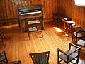 Great Moulton Chapel,Interior 1.JPG 3,264 × 2,448; 4.03 MB
-
 Tin Tabernacle, Greet - geograph.org.uk - 195150.jpg 640 × 480; 63 KB
-
 Gristhorpe, St Thomas's Church - geograph.org.uk - 231169.jpg 432 × 285; 17 KB
-
 Guides Hut Gaddesden Row - geograph.org.uk - 41193.jpg 640 × 480; 32 KB
-
 Halling Baptist Chapel - geograph.org.uk - 1083609.jpg 640 × 481; 110 KB
-
 Hollybush Church Room - geograph.org.uk - 647580.jpg 640 × 480; 143 KB
-
 Hythe, Kent, St Michael, Tin Tabernacle, front bis.jpg 2,272 × 1,704; 1.59 MB
-
 Hythe, Kent, St Michael, Tin Tabernacle, front.jpg 2,272 × 1,704; 1.64 MB
-
 Hythe, Kent, St Michael, Tin Tabernacle, side.jpg 2,272 × 1,704; 1.7 MB
-
 Iron Chapel, Uckington - geograph.org.uk - 76452.jpg 640 × 479; 102 KB
-
 Iron Church at Abbey Lane Leicester.jpg 4,032 × 3,024; 2.63 MB
-
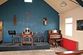 Kent Life Museum, Standling, chapel interior.jpg 3,888 × 2,592; 3.55 MB
-
 Kent Life Museum, Standling, chapel.jpg 3,888 × 2,592; 3.4 MB
-
 Tin tabernacle.JPG 2,304 × 1,728; 1.71 MB
-
 Former Mission Hall, Lidsey (Parish of Aldingbourne).JPG 2,550 × 1,800; 1.02 MB
-
 Little Pink Church, Linwood - geograph.org.uk - 611037.jpg 480 × 640; 151 KB
-
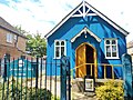 Little Blue Church 2022.jpg 4,160 × 3,120; 5.68 MB
-
 Little Hay Mission Church - geograph.org.uk - 6328.jpg 600 × 450; 106 KB
-
 Former tin tabernacle church in Masham, North Yorkshire.jpg 640 × 480; 66 KB
-
 Moorcourt Church - geograph.org.uk - 439538.jpg 640 × 426; 130 KB
-
 Morden Baptist Church Tin Tabernacle on Crown Road.gif 488 × 307; 146 KB
-
 Newton Heath Evangelical Church.jpg 2,816 × 2,112; 959 KB
-

-
 Tin Tabernacle in Old Heath - geograph.org.uk - 99670.jpg 640 × 454; 46 KB
-
 Old Heath Congregational Church Old Heath Fingringhoe Road Colchester Essex UK.jpg 3,480 × 2,547; 4.12 MB
-
 Oldfield Park Methodist Church and Institute.jpg 3,072 × 2,304; 2.9 MB
-
 Oldfield Park Methodist Church, Institute entrance.jpg 2,200 × 3,032; 4.7 MB
-
 Oldfield Park Methodist Church, Institute.jpg 3,072 × 2,304; 3.44 MB
-
 Parish Hall in Kempsey - geograph.org.uk - 631096.jpg 640 × 426; 39 KB
-
 Poverest Coronation Hall - geograph.org.uk - 1078823.jpg 640 × 480; 79 KB
-
 Rodley - Old Chapel - geograph.org.uk - 159552.jpg 640 × 480; 88 KB
-
 St Gabriel Church, Rough Common - geograph.org.uk - 1133311.jpg 640 × 430; 103 KB
-
 Christ the King Church in Rushall - geograph.org.uk - 264065.jpg 500 × 450; 179 KB
-
 Saxlingham Nethergate Chapel - geograph.org.uk - 358116.jpg 640 × 480; 99 KB
-
 Chapel, Silverdale Cemetery - geograph.org.uk - 65256.jpg 640 × 480; 119 KB
-
 St Andrew's Church, Hadlow Stair, Tonbridge.JPG 2,400 × 1,800; 1.18 MB
-
 St John's Church - geograph.org.uk - 98579.jpg 640 × 480; 143 KB
-
 St Johns - geograph.org.uk - 365038.jpg 640 × 472; 147 KB
-
 St Mary the Virgin Church, Shepperdine (Geograh Image 3062012 b81b9659).jpg 2,592 × 1,944; 1.52 MB
-
 St Mary's Church, Shepperdine (Geograph Image 2683599 24c9f773).jpg 1,024 × 769; 187 KB
-
 St Michael, Hythe, Kent - geograph.org.uk - 326043.jpg 640 × 500; 147 KB
-
 St Peter, Lower Withington.jpg 819 × 614; 200 KB
-
 St Peters Lower Withington.jpg 4,826 × 2,407; 4.7 MB
-

-
 Still going strong - geograph.org.uk - 94877.jpg 640 × 426; 103 KB
-
 Corrugated Tin Chapel, Swineford - panoramio.jpg 2,652 × 1,830; 1.07 MB
-
 Swineford Primary School - geograph.org.uk - 1755505.jpg 640 × 494; 102 KB
-
 Tatsfield WI Hall - geograph.org.uk - 855266.jpg 640 × 426; 95 KB
-
 The 'tin tabernacle' - geograph.org.uk - 1497384.jpg 470 × 640; 152 KB
-
 The Good Shepherd Mission, Scarisbrick.jpg 4,491 × 3,370; 2.95 MB
-
 Tin Tabernacle at Thorlby - geograph.org.uk - 1396771.jpg 640 × 480; 187 KB
-
 Thrupp tin church.jpg 640 × 480; 81 KB
-
 Tin Chapel, Sole Street, Kent.jpg 3,168 × 2,538; 1.98 MB
-
 Tin Tabernacle - geograph.org.uk - 183598.jpg 640 × 427; 71 KB
-
 Tin tabernacle - geograph.org.uk - 1976588.jpg 640 × 426; 163 KB
-
 Tin tabernacle - geograph.org.uk - 83145.jpg 640 × 426; 86 KB
-
 Tin tabernacle, Basingstoke - geograph.org.uk - 4162399.jpg 1,219 × 1,600; 434 KB
-
 Tin Tabernacle, Dullingham - geograph.org.uk - 4664139.jpg 900 × 639; 416 KB
-
 Tin tabernacle, Main Street, Frodsham - geograph.org.uk - 6324979.jpg 2,432 × 1,824; 2.49 MB
-
 Wallsend Spiritualist Church - geograph.org.uk - 591715.jpg 640 × 425; 67 KB
-
 The Mission Church, Woodmancote - geograph.org.uk - 227978.jpg 640 × 479; 177 KB


_St_Michael%27s_Church_-_geograph.org.uk_-_68146.jpg)


,_New_Road,_Chilworth_(March_2014).JPG)

_-_geograph.org.uk_-_1297735.jpg)
_-_geograph.org.uk_-_1297739.jpg)


_Church_(a.k.a._Mission_Hall),_Barnett_Wood_Lane,_Ashtead.JPG)


.jpg)


,_Cheam_Road,_Ewell.JPG)
.JPG)


.JPG)


.jpg)
.jpg)


