Category:Tiendweg 42, Harmelen
Jump to navigation
Jump to search
| Object location | | View all coordinates using: OpenStreetMap |
|---|
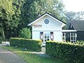
building in Woerden, Netherlands  | |||||
| Upload media | |||||
| Instance of | |||||
|---|---|---|---|---|---|
| Location | Harmelen, Utrecht, Netherlands | ||||
| Street address |
| ||||
| Located on street |
| ||||
| Heritage designation |
| ||||
 | |||||
Nederlands: Jacht-Rust
|
This is a category about rijksmonument number 20830
|
| Address |
|
Media in category "Tiendweg 42, Harmelen"
The following 10 files are in this category, out of 10 total.
-
 Exterieur - Harmelen - 20102419 - RCE.jpg 1,200 × 960; 357 KB
-
 Exterieur - Harmelen - 20102420 - RCE.jpg 1,200 × 958; 371 KB
-
 Gepleisterd pandje onder overstekend pannen zadeldak 2012-08-01 09-48-57.jpg 2,592 × 1,944; 1.32 MB
-
 Gepleisterd pandje onder overstekend pannen zadeldak 2012-08-01 09-50-15.jpg 2,592 × 1,944; 1.28 MB
-
 Jacht-Rust", voorgevel - Harmelen - 20102585 - RCE.jpg 1,200 × 808; 242 KB
-
 Rechter zijgevel - Harmelen - 20102584 - RCE.jpg 1,200 × 1,195; 390 KB
-

-

-
 Voorzijde - Harmelen - 20102583 - RCE.jpg 1,200 × 1,193; 396 KB
-
 Zijgevel - Harmelen - 20102586 - RCE.jpg 1,200 × 804; 230 KB


