Category:Tieffurtmühle, 1803 (Tieffurtstrasse 2, Dottikon)
Jump to navigation
Jump to search
| Object location | | View all coordinates using: OpenStreetMap |
|---|
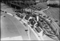
mill building in Dottikon in the canton of Aargau, Switzerland  | |||||
| Upload media | |||||
| Instance of |
| ||||
|---|---|---|---|---|---|
| Part of | |||||
| Location | Dottikon, Bremgarten District, Aargau, Switzerland | ||||
| Street address |
| ||||
| Has part(s) | |||||
| Heritage designation | |||||
| Inception |
| ||||
 | |||||
Subcategories
This category has the following 2 subcategories, out of 2 total.
Media in category "Tieffurtmühle, 1803 (Tieffurtstrasse 2, Dottikon)"
The following 3 files are in this category, out of 3 total.
-
 2022-Dottikon-Tieffurtmuehle.jpg 1,920 × 1,280; 2.29 MB
-
 ETH-BIB-Dottikon, Tieffurtmühle-LBS H1-015292.tif 6,695 × 4,606; 88.39 MB
-
 ETH-BIB-Dottikon, Tieffurtmühle-LBS H1-026865.tif 8,445 × 5,959; 144.02 MB