Category:Throckmorton, Worcestershire
Jump to navigation
Jump to search
village and civil parish in Wychavon, Worcestershire, United Kingdom  | |||||
| Upload media | |||||
| Instance of | |||||
|---|---|---|---|---|---|
| Location | Wychavon, Worcestershire, West Midlands, England | ||||
| Population |
| ||||
| Area |
| ||||
| Said to be the same as | Throckmorton (Wikimedia duplicated page, civil parish) | ||||
 | |||||
Subcategories
This category has the following 2 subcategories, out of 2 total.
R
- RAF Pershore (11 F)
T
- Throckmorton Church (17 F)
Media in category "Throckmorton, Worcestershire"
The following 49 files are in this category, out of 49 total.
-
 All directions - geograph.org.uk - 1277141.jpg 426 × 640; 75 KB
-
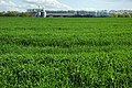
 Arable land at Throckmorton - geograph.org.uk - 1088945.jpg 640 × 426; 78 KB
-
 Arable land near Thockmorton - geograph.org.uk - 1277281.jpg 640 × 426; 76 KB
-
 Autumnal footpath - geograph.org.uk - 1027200.jpg 640 × 480; 175 KB
-
 Avenue from the church, Throckmorton - geograph.org.uk - 6625272.jpg 1,024 × 768; 318 KB
-
 Barn at Throckmorton Court - geograph.org.uk - 1089188.jpg 640 × 426; 110 KB
-
 Barns and church at Throckmorton - geograph.org.uk - 1027201.jpg 640 × 480; 96 KB
-
 Barns in Throckmorton - geograph.org.uk - 1089171.jpg 640 × 426; 106 KB
-
 Behind the church, Throckmorton - geograph.org.uk - 6609771.jpg 1,024 × 768; 294 KB
-
 Drive to Throckmorton sewage works - geograph.org.uk - 4059982.jpg 800 × 451; 206 KB
-

-

-
 Entrance to Rotherdale Farm - geograph.org.uk - 4060035.jpg 800 × 451; 189 KB
-
 Farm buildings at Tilesford - geograph.org.uk - 1277285.jpg 640 × 426; 131 KB
-
 Fly tipping at Throckmorton - geograph.org.uk - 1089202.jpg 640 × 426; 86 KB
-
 Footpath by the churchyard, Throckmorton - geograph.org.uk - 6625280.jpg 1,024 × 768; 385 KB
-
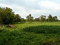
 Grass field at Throckmorton - geograph.org.uk - 6625211.jpg 1,024 × 768; 170 KB
-
 Hill and Moor land-fill site - geograph.org.uk - 1092156.jpg 640 × 426; 96 KB
-
 Landscaped land-fill site - geograph.org.uk - 1092097.jpg 640 × 426; 61 KB
-
 Litter near Throckmorton - geograph.org.uk - 1092126.jpg 640 × 426; 115 KB
-
 Littered watercourse, Throckmorton - geograph.org.uk - 1092145.jpg 426 × 640; 125 KB
-
 Long Lane - geograph.org.uk - 4059992.jpg 800 × 451; 212 KB
-
 Long Lane - geograph.org.uk - 4060025.jpg 800 × 451; 199 KB
-
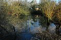 Moat at Throckmorton - geograph.org.uk - 1088937.jpg 640 × 426; 122 KB
-
 Moat at Throckmorton - geograph.org.uk - 1088939.jpg 426 × 640; 116 KB
-
 Morning dew on a flower - geograph.org.uk - 2139891.jpg 3,648 × 2,736; 2.45 MB
-
 Old orchard land - geograph.org.uk - 3306570.jpg 800 × 600; 348 KB
-
 Ordnance Survey Cut Mark - geograph.org.uk - 6119198.jpg 1,024 × 710; 310 KB
-
 Ploughed field at Throckmorton - geograph.org.uk - 1089178.jpg 640 × 426; 84 KB
-
 Rotherdale Farm, Throckmorton - geograph.org.uk - 4313895.jpg 640 × 469; 68 KB
-
 Rush hour in Throckmorton - geograph.org.uk - 4888428.jpg 640 × 480; 100 KB
-
 Throckmorton Airfield - geograph.org.uk - 4060002.jpg 800 × 451; 181 KB
-
 Throckmorton Chapelry, graves (a) - geograph.org.uk - 4888432.jpg 640 × 480; 76 KB
-
 Throckmorton Chapelry, graves (b) - geograph.org.uk - 4888435.jpg 640 × 480; 95 KB
-
 Throckmorton Chapelry, noticeboard - geograph.org.uk - 4888436.jpg 640 × 480; 152 KB
-
 Throckmorton church - geograph.org.uk - 6625215.jpg 1,024 × 768; 237 KB
-
 Tilesford - geograph.org.uk - 50283.jpg 640 × 480; 100 KB
-
 Tilesford Cottages - geograph.org.uk - 4060019.jpg 800 × 451; 211 KB
-
 Triangulation pillar, Throckmorton - geograph.org.uk - 374495.jpg 640 × 480; 114 KB
-
 Vale Green Energy, Rotherdale Farm - geograph.org.uk - 4313816.jpg 640 × 480; 78 KB
-

-
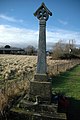 War Memorial, Throckmorton - geograph.org.uk - 1088681.jpg 426 × 640; 73 KB
-
 Entrance to Bishampton Village - geograph.org.uk - 47371.jpg 640 × 480; 73 KB
-
 Hill and Moor Land-fill Site - geograph.org.uk - 46904.jpg 640 × 480; 64 KB
-

-
 Landscaped approach to landfill site - geograph.org.uk - 272646.jpg 640 × 480; 112 KB
-
 Lettuces - geograph.org.uk - 468060.jpg 640 × 480; 194 KB
-
 Sunlit standard - geograph.org.uk - 406656.jpg 480 × 640; 149 KB
-
 Young trees near The Larches Farm - geograph.org.uk - 441872.jpg 640 × 426; 127 KB


_-_geograph.org.uk_-_4888432.jpg)
_-_geograph.org.uk_-_4888435.jpg)


