Category:Thornton-le-Street
Jump to navigation
Jump to search
village and civil parish in North Yorkshire, United Kingdom  | |||||
| Upload media | |||||
| Instance of | |||||
|---|---|---|---|---|---|
| Location | Hambleton, North Yorkshire, Yorkshire and the Humber, England | ||||
| Population |
| ||||
 | |||||
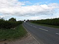
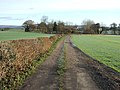
English: Thornton-le-Street is a village and civil parish in the Hambleton district of North Yorkshire, England. It is situated on the A168 (the Thirsk to Northallerton road), about three miles north of Thirsk.
Subcategories
This category has the following 2 subcategories, out of 2 total.
T
Media in category "Thornton-le-Street"
The following 72 files are in this category, out of 72 total.
-
 A Corner of Thornton-le-Street - geograph.org.uk - 5661249.jpg 5,152 × 3,864; 6.93 MB
-
 A View from the A168 - geograph.org.uk - 5660921.jpg 5,152 × 3,864; 7.5 MB
-
 A168 - geograph.org.uk - 5456414.jpg 2,560 × 1,440; 929 KB
-
 A168 at Thornton le Street - geograph.org.uk - 405912.jpg 640 × 480; 62 KB
-
 A168 heading north - geograph.org.uk - 2718577.jpg 640 × 480; 84 KB
-
 A168 towards Northallerton - geograph.org.uk - 2716961.jpg 640 × 480; 71 KB
-
 A168 towards Northallerton - geograph.org.uk - 2718583.jpg 640 × 480; 58 KB
-
 Access into Thornton Park from East Lodges - geograph.org.uk - 5661673.jpg 5,152 × 3,864; 7 MB
-
 Access Lane heading towards East Lodges - geograph.org.uk - 5661675.jpg 5,152 × 3,864; 6.33 MB
-
 Access Lane in Bell Rush - geograph.org.uk - 5661692.jpg 5,152 × 3,864; 7.19 MB
-
 Approaching Thornton-le-Street Stud - geograph.org.uk - 3605750.jpg 1,600 × 1,200; 386 KB
-
 Barley field next to Cod Beck - geograph.org.uk - 3626350.jpg 3,872 × 2,592; 4.08 MB
-
 Beal House - geograph.org.uk - 3604223.jpg 1,600 × 1,200; 709 KB
-
 Benchmark on Brawith Bridge - geograph.org.uk - 6561534.jpg 1,808 × 3,124; 2.74 MB
-
 Benchmark on East Lodge, Thornton Park - geograph.org.uk - 6561562.jpg 1,808 × 3,165; 3.08 MB
-
 Bolt on St. Leonard's Church - geograph.org.uk - 6561574.jpg 1,816 × 2,690; 1.26 MB
-
 Brawith Bridge - geograph.org.uk - 1805953.jpg 640 × 480; 110 KB
-
 Brawith Bridge - geograph.org.uk - 3626342.jpg 3,872 × 2,592; 4.86 MB
-
 Brawith Bridge over Cod Beck - geograph.org.uk - 2526161.jpg 800 × 600; 275 KB
-
 Building in Big Wood - geograph.org.uk - 3605756.jpg 1,600 × 1,200; 1.01 MB
-
 Cod Beck - geograph.org.uk - 2716949.jpg 640 × 480; 84 KB
-
 Cod Beck at Brawith Bridge - geograph.org.uk - 6550511.jpg 3,888 × 5,184; 5.7 MB
-
 Cod Beck Footbridge - geograph.org.uk - 1805769.jpg 3,648 × 2,736; 3.46 MB
-
 Cod Beck Mill Race - geograph.org.uk - 1805778.jpg 640 × 480; 123 KB
-
 East Lodge South - geograph.org.uk - 2716983.jpg 640 × 480; 72 KB
-
 East Lodges, Thornton Park - geograph.org.uk - 6561554.jpg 1,455 × 1,970; 1.01 MB
-
 Entrance to Old Hall Farm - geograph.org.uk - 3626381.jpg 3,872 × 2,592; 4.54 MB
-
 Farm at Viewly Hill - geograph.org.uk - 3604227.jpg 1,600 × 1,200; 449 KB
-
 Farm buildings at Leachfield Grange - geograph.org.uk - 2797084.jpg 3,256 × 1,632; 1.35 MB
-
 Farmland near Cod Beck - geograph.org.uk - 2718580.jpg 640 × 480; 104 KB
-
 Farmland off the A168 - geograph.org.uk - 2716959.jpg 640 × 480; 92 KB
-
 Farmland, North Kilvington - geograph.org.uk - 2716969.jpg 640 × 480; 71 KB
-
 Farmland, Viewly Hill - geograph.org.uk - 2718576.jpg 640 × 480; 75 KB
-
 Field by Street House Farm - geograph.org.uk - 3626710.jpg 3,872 × 2,592; 4.16 MB
-
 Field edge footpath - geograph.org.uk - 2797077.jpg 2,448 × 3,264; 2.4 MB
-
 Field of barley near Thornton-le-Street - geograph.org.uk - 3626334.jpg 3,872 × 2,592; 3.52 MB
-
 Field of sheep opposite Street House Farm - geograph.org.uk - 3626676.jpg 3,872 × 2,592; 4.61 MB
-
 Footpath junction Thornton le Moor - geograph.org.uk - 2797073.jpg 3,264 × 2,448; 2.49 MB
-
 Footpath towards Leachfield Grange - geograph.org.uk - 3604214.jpg 1,600 × 1,200; 522 KB
-
 Ford Cottage - geograph.org.uk - 1805567.jpg 640 × 474; 117 KB
-
 Former public house at Thornton le Street - geograph.org.uk - 405952.jpg 640 × 480; 100 KB
-
 Grazing land off the A168 - geograph.org.uk - 2716977.jpg 640 × 480; 77 KB
-
 Large house at Beal Grange - geograph.org.uk - 3604222.jpg 1,600 × 1,200; 547 KB
-
 Looking east from Viewly Hill trig point - geograph.org.uk - 3604236.jpg 1,600 × 1,200; 617 KB
-
 Metal Footbridge over Cod Beck - geograph.org.uk - 6322383.jpg 5,184 × 3,456; 5.38 MB
-
 Old Corn Mill Graffiti - geograph.org.uk - 1805915.jpg 3,439 × 2,189; 2.27 MB
-
 On a Footpath entering High Plantation - geograph.org.uk - 5661710.jpg 5,152 × 3,864; 6.56 MB
-
 Plough near Thornton-le-Street - geograph.org.uk - 2132177.jpg 640 × 480; 92 KB
-
 Rain approaching North Kilvington - geograph.org.uk - 3626741.jpg 3,872 × 2,592; 1.36 MB
-
 Sandholme Farm - geograph.org.uk - 1806010.jpg 3,648 × 2,736; 4.47 MB
-
 St. Leonard's Church, Thornton-le-Street (1) - geograph.org.uk - 5661231.jpg 5,152 × 3,864; 7 MB
-
 St. Leonard's Church, Thornton-le-Street (2) - geograph.org.uk - 5661236.jpg 5,152 × 3,864; 7.28 MB
-
 Street House Farm - geograph.org.uk - 2716975.jpg 640 × 353; 39 KB
-
 Swale Way Logo - geograph.org.uk - 5661735.jpg 5,152 × 3,864; 7.55 MB
-
 The A168 near North Kilvington - geograph.org.uk - 3626731.jpg 3,872 × 2,592; 4.85 MB
-
 The Old Corn Mill - geograph.org.uk - 1805859.jpg 3,564 × 2,072; 5.83 MB
-
 Thirsk and Northallerton Golf Club - geograph.org.uk - 2716953.jpg 640 × 480; 78 KB
-
 Thornton-le-Street - geograph.org.uk - 3626600.jpg 3,872 × 2,592; 3.18 MB
-
 Thornton-le-Street and North Kilvington Village Hall - geograph.org.uk - 1805548.jpg 3,648 × 2,155; 5.41 MB
-
 Track to Chapel Farm - geograph.org.uk - 2716966.jpg 640 × 480; 100 KB
-
 Track to North Kilvington - geograph.org.uk - 3626726.jpg 3,682 × 2,455; 3.48 MB
-
 Viewly Hill trig point - geograph.org.uk - 3604232.jpg 1,600 × 1,200; 904 KB
-
 Village Hall at Thornton le Street - geograph.org.uk - 405919.jpg 640 × 480; 101 KB
-
 Village Pump, Thornton-le-Street - geograph.org.uk - 1805576.jpg 2,358 × 3,462; 4.15 MB
-
 Wheat field near Street House Farm - geograph.org.uk - 3626698.jpg 3,872 × 2,592; 4.99 MB
-
 Wooden Structure on the Edge of Big Wood - geograph.org.uk - 5661682.jpg 5,152 × 3,864; 7.14 MB
-
 Footbridge over Cod Beck - geograph.org.uk - 405940.jpg 640 × 480; 147 KB
-

-
 Metcalfe's of Thirsk vehicle recovery - geograph.org.uk - 547220.jpg 640 × 426; 43 KB
-
 Sandholme Farm - geograph.org.uk - 405945.jpg 640 × 480; 108 KB
-
 Street House Farm, Thornton le Street - geograph.org.uk - 405906.jpg 640 × 480; 66 KB
-
 Thornton Mill - geograph.org.uk - 405934.jpg 640 × 480; 101 KB


_-_geograph.org.uk_-_5661231.jpg)
_-_geograph.org.uk_-_5661236.jpg)


_at_Thornton_le_Street_-_geograph.org.uk_-_405926.jpg)


