Category:Theresienstraße (Köln)
Jump to navigation
Jump to search
| Object location | | View all coordinates using: OpenStreetMap |
|---|
street in Cologne, Germany | |||||
| Upload media | |||||
| Instance of | |||||
|---|---|---|---|---|---|
| Location | Cologne, Cologne Government Region, North Rhine-Westphalia, Germany | ||||
 | |||||
Media in category "Theresienstraße (Köln)"
The following 35 files are in this category, out of 35 total.
-
 Emilie Wolff Theresienstraße 59.jpg 2,192 × 2,167; 1.21 MB
-
 Köln Theresienstr 40.jpg 1,783 × 2,102; 748 KB
-
 Köln Theresienstrasse 36 2.jpg 1,694 × 2,069; 843 KB
-
 Köln Theresienstrasse 36 38 40.jpg 2,524 × 1,656; 951 KB
-
 Köln Theresienstrasse 36 38.jpg 2,572 × 1,840; 1.24 MB
-
 Stolperstein Köln, Elsa Buchholz (Theresienstraße 75).jpg 2,297 × 2,269; 912 KB
-
 Stolperstein Köln, Eugen Strauss (Theresienstraße 19).jpg 3,168 × 3,194; 4.25 MB
-
 Stolperstein Köln, Hedwig Henriette Strauss (Theresienstraße 19).jpg 3,616 × 3,600; 5.36 MB
-
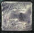 Stolpersteine Köln, Emilie Wolff (Theresienstraße 59).jpg 3,427 × 3,330; 5.03 MB
-
 Stolpersteine Köln, Hedwig Henriette und Eugen Strauss (Theresienstraße 19).jpg 1,805 × 3,540; 2.57 MB
-
 Stolpersteine Köln, Verlegeort Theresienstraße 19.jpg 4,733 × 3,570; 6.63 MB
-
 Stolpersteine Köln, Verlegeort Theresienstraße 59.jpg 3,648 × 4,864; 6.11 MB
-
 Stolpersteine Köln, Verlegestelle Theresienstraße 19.jpg 3,021 × 3,784; 4.72 MB
-
 Stolpersteine Köln, Verlegestelle Theresienstraße 59.jpg 3,108 × 3,570; 4.69 MB
-
 Stolpersteine Köln, Wohnhaus Theresienstraße 19 (2).jpg 4,590 × 3,648; 4.71 MB
-
 Stolpersteine Köln, Wohnhaus Theresienstraße 19.jpg 4,728 × 3,468; 4.63 MB
-
 Stolpersteine Köln, Wohnhaus Theresienstraße 75.jpg 3,672 × 4,896; 1.71 MB
-
 Theresienstrasse 32.jpg 2,544 × 3,456; 1.9 MB
-
 Theresienstrasse 34.jpg 2,328 × 3,608; 2.12 MB
-
 Theresienstrasse 36 1.jpg 1,870 × 2,268; 1,023 KB
-
 Theresienstrasse 38 32.jpg 4,412 × 3,440; 4.03 MB
-
 Theresienstrasse 38 33.jpg 4,587 × 3,476; 3.74 MB
-
 Theresienstrasse 38 34.jpg 3,568 × 3,837; 2.52 MB
-
 Theresienstrasse 38 Giebel.jpg 3,031 × 4,607; 3.16 MB
-
 Theresienstrasse 53.jpg 2,424 × 3,504; 2.15 MB
-
 WLM13 K Theresienstrasse 31 33.jpg 2,184 × 2,768; 1.21 MB
-
 WLM13 K Theresienstrasse 31.jpg 2,416 × 3,584; 1.51 MB
-
 WLM13 K Theresienstrasse 34a.jpg 3,000 × 4,000; 1.86 MB
-
 WLM13 K Theresienstrasse 34b.jpg 3,000 × 4,000; 2.12 MB
-
 WLM13 K Theresienstrasse 36 Giebel Detail.jpg 4,000 × 3,000; 3.51 MB
-
 WLM13 K Theresienstrasse 36 n.jpg 2,856 × 2,912; 1.99 MB
-
 WLM13 K Theresienstrasse 36 Tapete.jpg 3,000 × 4,000; 2.14 MB
-
 WLM13 K Theresienstrasse 38 Giebel.jpg 4,000 × 3,000; 3.35 MB
-
 WLM13 K Theresienstrasse34 Giebel.jpg 4,000 × 3,000; 3.44 MB
-
 WLM13 Theresienstrasse 29.jpg 3,000 × 4,000; 2.48 MB


.jpg)
.jpg)
.jpg)
.jpg)
.jpg)


.jpg)


