Category:The Trundle
Jump to navigation
Jump to search
hillfort in West Sussex, England, UK   | |||||
| Upload media | |||||
| Instance of | |||||
|---|---|---|---|---|---|
| Location | Singleton, Chichester, West Sussex, South East England, England | ||||
| Heritage designation |
| ||||
 | |||||
Media in category "The Trundle"
The following 56 files are in this category, out of 56 total.
-
 Chalkpit Lane, East Lavant 03.jpg 4,000 × 3,000; 3.23 MB
-
 Chalkpit Lane, East Lavant 05.jpg 4,000 × 3,000; 4.67 MB
-
 Chalkpit Lane, East Lavant 06.jpg 4,000 × 3,000; 3.7 MB
-
 Chalkpit Lane, East Lavant 09.jpg 4,000 × 3,000; 3.73 MB
-
 On the ramparts at The Trundle - geograph.org.uk - 6416772.jpg 1,024 × 683; 188 KB
-
 St Roc's Hill 1723 from William Stukeley's Itinerarium Curiosum.jpg 1,382 × 416; 454 KB
-
 St Roche's Hill Sussex by T King from William Hayley Mason Goodwood 1839.jpg 1,348 × 837; 667 KB
-
 The Trundle 1.jpg 2,560 × 1,920; 2.08 MB
-
 The Trundle 2.jpg 2,560 × 1,920; 2.33 MB
-
 The Trundle 3.jpg 2,560 × 1,920; 2.32 MB
-
 The Trundle 4.jpg 2,560 × 1,920; 2.12 MB
-
 The Trundle 5.jpg 2,560 × 1,920; 2.19 MB
-
 The Trundle 6.jpg 2,560 × 1,920; 2.19 MB
-
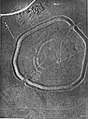 The Trundle aerial photo 1925.jpg 1,031 × 1,397; 792 KB
-
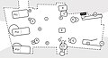
 The Trundle annotated 1928 and 1930 dig.jpg 1,215 × 863; 407 KB
-
 The Trundle annotated 1928 dig.jpg 1,150 × 1,059; 573 KB
-
 The Trundle carparks. Looking South-west towards the Isle Of Wight. - panoramio.jpg 2,144 × 1,349; 1,023 KB
-
 The Trundle Digital Terrain Model.jpg 1,920 × 1,080; 1,004 KB
-
 The Trundle east gate 1930 excavations annotated.jpg 1,200 × 650; 417 KB
-
 The Trundle, earthworks and view north.jpg 2,800 × 2,100; 4.62 MB
-
 The Trundle, St.Roche's Hill, Sussex - geograph.org.uk - 1757076.jpg 3,872 × 2,592; 2.16 MB
-
 The Trundle, St.Roche's Hill, Sussex - geograph.org.uk - 1757079.jpg 3,872 × 2,592; 2.38 MB
-
 The Trundle, St.Roche's Hill, Sussex - geograph.org.uk - 1757102.jpg 3,872 × 2,592; 4.11 MB
-
 The Trundle, West Sussex 01.jpg 4,000 × 3,000; 3.28 MB
-
 The Trundle, West Sussex 02.jpg 4,000 × 3,000; 3.44 MB
-
 The Trundle, West Sussex 03.jpg 4,000 × 3,000; 2.91 MB
-
 The Trundle, West Sussex 04.jpg 4,000 × 3,000; 3.65 MB
-
 The Trundle, West Sussex 05.jpg 4,000 × 3,000; 3.54 MB
-
 The Trundle, West Sussex 06.jpg 4,000 × 3,000; 3.06 MB
-
 The Trundle, West Sussex 07.jpg 4,000 × 3,000; 3.12 MB
-
 The Trundle, West Sussex 08.jpg 4,000 × 3,000; 2.98 MB
-
 The Trundle, West Sussex 09.jpg 4,000 × 3,000; 3.61 MB
-
 The Trundle, West Sussex 10.jpg 4,000 × 3,000; 2.96 MB
-
 The Trundle, West Sussex 11.jpg 4,000 × 3,000; 3.73 MB
-
 The Trundle, West Sussex 12.jpg 4,000 × 3,000; 3.37 MB
-
 The Trundle, West Sussex 13.jpg 4,000 × 3,000; 3.9 MB
-
 The Trundle, West Sussex 14.jpg 4,000 × 3,000; 3.92 MB
-
 The Trundle, West Sussex 15.jpg 4,000 × 3,000; 3.57 MB
-
 The Trundle, West Sussex 16.jpg 4,000 × 3,000; 3.62 MB
-
 The Trundle, West Sussex 17.jpg 4,000 × 3,000; 3.97 MB
-
 The Trundle, West Sussex 18.jpg 4,000 × 3,000; 3.98 MB
-
 The Trundle, West Sussex 19.jpg 4,000 × 3,000; 4.14 MB
-
 The Trundle, West Sussex 20.jpg 4,000 × 3,000; 3.7 MB
-
 The Trundle, West Sussex 21.jpg 4,000 × 3,000; 3.27 MB
-
 The Trundle, West Sussex 22.jpg 4,000 × 3,000; 4.21 MB
-
 The Trundle, West Sussex 23.jpg 4,000 × 3,000; 4.11 MB
-
 The Trundle, West Sussex 24.jpg 4,000 × 3,000; 4.14 MB
-
 The Trundle, West Sussex 25.jpg 4,000 × 3,000; 3.83 MB
-
 The Trundle, West Sussex 26.jpg 4,000 × 3,000; 3.97 MB
-
 The Trundle, West Sussex 27.jpg 4,000 × 3,000; 4.47 MB
-
 The Trundle. - geograph.org.uk - 176137.jpg 640 × 436; 137 KB
-
 Trig Point on St.Roche's Hill, Sussex - geograph.org.uk - 1757011.jpg 3,872 × 2,592; 5.03 MB
-
 Trig point on The Trundle - geograph.org.uk - 3524677.jpg 1,024 × 768; 175 KB
-
 Trig point on The Trundle - geograph.org.uk - 3586674.jpg 1,333 × 1,000; 1.24 MB
-
 Trundle Hill Trig-point. Looking East across Goodwood Racecourse. - panoramio.jpg 2,947 × 2,174; 2.13 MB
-
 View from the 6 Furlong Marker - geograph.org.uk - 225475.jpg 640 × 479; 92 KB


