Category:The Spur (Senglea)
Jump to navigation
Jump to search
| Object location | | View all coordinates using: OpenStreetMap |
|---|
bastion in Malta  | |||||
| Upload media | |||||
| Instance of | |||||
|---|---|---|---|---|---|
| Location | Senglea, Port Region (Port), Malta | ||||
| Street address |
| ||||
| Heritage designation |
| ||||
 | |||||
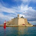
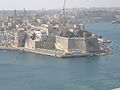
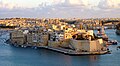
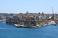
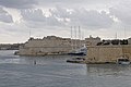
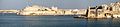
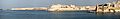
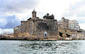
The Spur is the bastion commanding the salient point of the promontory of Senglea. It is often mistakenly referred to as Fort Saint Michael, which is actually on the opposite end of the fortified city.
Subcategories
This category has the following 4 subcategories, out of 4 total.
Media in category "The Spur (Senglea)"
The following 65 files are in this category, out of 65 total.
-
 "Gardjola" (The Watch Tower), Senglea, Grand Harbour, Malta GC- Photo by Gino Galea.jpg 3,058 × 4,504; 5.54 MB
-
 Entrée du port de La Valette à Malte.jpg 2,979 × 1,913; 1.1 MB
-
 HMS Agamemnon arriving at Malta and Passing Fort St Angelo Art.IWMART3119.jpg 3,508 × 1,647; 1.42 MB
-
 7ina.jpg 768 × 768; 162 KB
-
 Bartizan in Malta.JPG 3,000 × 4,000; 5.56 MB
-
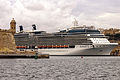 Celebrity Silhouette in Valletta 05.jpg 3,264 × 2,176; 1.65 MB
-
 DSC5976 - Kasimov.jpg 6,000 × 4,000; 7.87 MB
-
 Fort sint michael.JPG 3,264 × 2,448; 1.99 MB
-
 Fort St. Michael at Malta (sunset).jpg 3,800 × 2,084; 1.62 MB
-

-

-
 Grand Harbour - Senglea.jpg 2,458 × 1,400; 1.76 MB
-
 Grand Harbour seen from Triq Girolamo Cassar n02.jpg 4,215 × 1,489; 6.25 MB
-
 Ir - Rampa Ta' L - Isla, L-Isla, Malta - panoramio (12).jpg 2,592 × 1,936; 2.11 MB
-
 Ir - Rampa Ta' L - Isla, L-Isla, Malta - panoramio (13).jpg 2,592 × 1,936; 1.5 MB
-
 Lara Calleja 05 - Gardjola u Valletta.jpg 4,000 × 3,000; 3.11 MB
-
 Malta - Senglea + The Spur (Herbert Ganado Gardens) 01 ies.jpg 5,616 × 3,744; 15.38 MB
-
 Malta - Senglea + The Spur (Triq Girolamo Cassar) 01 ies.jpg 5,616 × 3,744; 14.56 MB
-
 Malta - Senglea - Ix-Xatt Juan B. Azzopardo + The Spur 01 ies.jpg 3,744 × 5,616; 16.75 MB
-
 Malta - Senglea - Ix-Xatt Juan B. Azzopardo + The Spur 02 ies.jpg 5,616 × 3,744; 15.15 MB
-
 Malta - Senglea - Ix-Xatt Juan B. Azzopardo + The Spur 03 ies.jpg 5,616 × 3,744; 17 MB
-
 Malta - Senglea - Ix-Xatt Juan B. Azzopardo + The Spur 04 ies.jpg 5,616 × 3,744; 14.99 MB
-
 Malta - Senglea - Ix-Xatt Juan B. Azzopardo - The Spur 01 ies.jpg 3,744 × 5,616; 16.6 MB
-
 Malta - Senglea - The Spur + Lower Spur Battery 01 ies.jpg 3,744 × 5,616; 15.44 MB
-
 Malta - Senglea - The Spur 01 ies.jpg 5,616 × 3,744; 16.65 MB
-
 Malta - Senglea - The Spur 02 ies.jpg 3,744 × 5,616; 10.91 MB
-
 Malta - Senglea - The Spur 03 ies.jpg 3,744 × 5,616; 16.68 MB
-
 Malta - Senglea - The Spur 04 ies.jpg 5,616 × 3,744; 17.16 MB
-
 Malta - Senglea - The Spur 05 ies.jpg 3,744 × 5,616; 15.46 MB
-
 Malta - Senglea - The Spur 06 ies.jpg 5,616 × 3,744; 15.6 MB
-
 Malta - Senglea - Triq it-Tarzna + Fort Saint Michael (Upper Barrakka Gardens) 01 ies.jpg 5,616 × 3,744; 16.35 MB
-
 Malta - Senglea - Triq Ix-Xatt Juan B. Azopardo - Fort Saint Michael (MSTHC) 04 ies.jpg 3,744 × 5,616; 12.93 MB
-
 Malta -mix- 2019 by-RaBoe 003.jpg 3,648 × 1,680; 4.59 MB
-
 Malta -mix- 2019 by-RaBoe 029.jpg 3,648 × 1,680; 4.75 MB
-
 Malta -mix- 2019 by-RaBoe 057.jpg 4,268 × 2,834; 10.42 MB
-
 Malta -mix- 2019 by-RaBoe 064.jpg 3,928 × 2,608; 9.69 MB
-
 Malta -mix- 2019 by-RaBoe 093.jpg 4,288 × 2,848; 10.19 MB
-
 Malta -mix- 2019 by-RaBoe 444.jpg 4,288 × 2,848; 11.67 MB
-
 Malta -mix- 2019 by-RaBoe 445.jpg 4,288 × 2,848; 11.92 MB
-
 Malta -mix- 2019 by-RaBoe 447.jpg 4,288 × 2,848; 11.29 MB
-
 Malta -mix- 2019 by-RaBoe 450.jpg 4,288 × 2,848; 10.44 MB
-
 Malta -mix- 2019 by-RaBoe 451.jpg 4,288 × 2,848; 9.9 MB
-
 Malta -mix- 2019 by-RaBoe 452.jpg 4,288 × 2,848; 9.95 MB
-
 Malta -mix- 2019 by-RaBoe 458.jpg 4,288 × 2,848; 8.97 MB
-
 Malta 240915 Challenger Senglea.jpg 2,400 × 1,600; 2.63 MB
-
 Malta Senglea BW 2011-10-07 13-07-36 fr.JPG 3,872 × 2,592; 5.58 MB
-
 Malta Valletta Panorama 02.jpg 9,600 × 2,127; 2.88 MB
-
 Malta Valletta Panorama 10.jpg 13,317 × 2,141; 3.81 MB
-
 Malta-senglea-57.jpg 1,700 × 970; 1.33 MB
-
 Malta-senglea-sunset.jpg 5,600 × 3,700; 9.67 MB
-
 Senglea (Malta) 2.jpg 2,816 × 2,112; 565 KB
-
 Senglea and Grand Harbour seen from Triq Girolamo Cassar n02 cropped.jpg 2,956 × 1,487; 2.66 MB
-
 Senglea-gardjolatower.jpg 1,720 × 1,100; 1.76 MB
-
 Sudika Isla from boat.jpg 1,200 × 798; 146 KB
-
 Sudika Isla from Valletta.jpg 1,600 × 1,064; 423 KB
-
 The lookout - Gardjola.jpg 2,841 × 5,052; 7.49 MB
-
 The Spur - Fortifications of Senglea as seen from Valletta at Sunset - Lucienne Spiteri.jpg 5,435 × 3,694; 8.54 MB
-
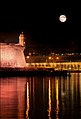
 The Spur - Fortifications of Senglea as seen from Valletta by night - Lucienne Spiteri.jpg 5,875 × 3,916; 20.93 MB
-
 The Spur as seen from the French Creek, Senglea.jpg 4,000 × 2,250; 1.89 MB
-
 The Spur at Sunset.jpg 774 × 436; 43 KB
-
 The Spur at the Grand Harbour.jpg 2,048 × 1,362; 249 KB
-
 The Spur, Senglea.jpg 4,000 × 3,000; 2.56 MB
-
 Valletta , Malta - panoramio (6).jpg 2,608 × 1,952; 1.18 MB
-
 Valletta 1980 Malta.jpg 2,700 × 1,800; 538 KB
-
 Valletta Blick auf Senglea 2.JPG 2,048 × 1,536; 1.48 MB
,_Senglea,_Grand_Harbour,_Malta_GC-_Photo_by_Gino_Galea.jpg)


.jpg)

.jpg)
.jpg)

_01_ies.jpg)
_01_ies.jpg)


_01_ies.jpg)
_04_ies.jpg)


_2.jpg)


.jpg)


_Voyage_en_Italie,_en_Sicile_et_%C3%A0_Malte_-_1778,_RP-T-00-493-90.jpg)