Category:The Old Post Office, Frankby
Jump to navigation
Jump to search
| Object location | | View all coordinates using: OpenStreetMap |
|---|
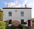
This is a category about listed building number 1242795. |
Grade II listed former post office on Frankby Green, Frankby, Wirral. Often confused with its successor as the post office, which is Well House Farm.
post office in Wirral, Merseyside, England, UK  | |||||
| Upload media | |||||
| Instance of | |||||
|---|---|---|---|---|---|
| Location | Wirral, Merseyside, North West England, England | ||||
| Heritage designation |
| ||||
 | |||||
Media in category "The Old Post Office, Frankby"
The following 2 files are in this category, out of 2 total.
-
 Datestone, The Old Post Office, Frankby.jpg 3,669 × 2,752; 7.4 MB
-
 The Old Post Office, Frankby.jpg 3,939 × 3,366; 8.71 MB
